پەڕگە:World empires and colonies around World War I.png
قەبارەی ئەم پێشبینینە: ٨٠٠ لە ٣٢٣ پیکسەڵ. ڕێزەلووشنەکانی تر: ٣٢٠ لە ١٢٩ پیکسەڵ | ٦٤٠ لە ٢٥٨ پیکسەڵ | ١٬٥٥٤ لە ٦٢٧ پیکسەڵ.
پەڕگەی سەرەکی (١٬٥٥٤ × ٦٢٧ پیکسڵ، قەبارەی پەڕگە: ٦٣ کیلۆبایت، جۆری ئێم ئای ئێم ئی: image/png)
کورتە
| وەسف |
English:
|
| ڕێکەوت | ٢ی ئابی ٢٠٠٧ (original upload date) |
| سەرچاوە | Taken from wikipedia map |
| بەرھەمھێنەر | خوارەوە ببینە. |
| وەشانەکانی تر |
.png)

|
This historical map image could be re-created using vector graphics as an SVG file. This has several advantages; see Commons:Media for cleanup for more information. If an SVG form of this image is available, please upload it and afterwards replace this template with
{{vector version available|new image name}}.
It is recommended to name the SVG file “World empires and colonies around World War I.svg”—then the template Vector version available (or Vva) does not need the new image name parameter. |
مۆڵەتنامە
Ishvara7 at ئینگلیزی ویکیپیدیا، ھەڵگری مافی لەبەرگرتنەوەی ئەم بەرھەمە، لەژێر ئەم مۆڵەتنامەیانەدا بڵاوی دەکاتەوە:

|
ڕێگەدراوە بە لەبەرگرتنەوە، دابەشکردن ھەروەھا/یان سازاندنی ئەم بەڵگەنامەیە لەژێر مەرجی مۆڵەتی GNU بۆ بەڵگەنامەی ئازاد، وەشانی ١.٢ یان ھەر وەشانێکی تری دواتر کە بڵاوکراوەتەوە لەلایەن دامەزراوەی بەرنامەی ئازاد، بەبێ ھیچ بەشێکی جیاواز، بەبێ نووسین لەسەر بەرگی پێشەوە و دواوەی. وێنەیەک لەمۆڵەتەکە لە بەشێکدا ھەیە کە ناوی مۆڵەتی GNU بۆ بەڵگەنامەی ئازادە. |
| ئەم پەڕگەیە لە ژێر مۆڵەتنامەی | ||
| دانەپاڵ: Ishvara7 at ئینگلیزی ویکیپیدیا | ||
| ||
| This licensing tag was added to this file as part of the GFDL licensing update. |
This file is licensed under the Creative Commons Attribution-Share Alike 2.5 Generic, 2.0 Generic and 1.0 Generic license.
دانەپاڵ: Ishvara7 at ئینگلیزی ویکیپیدیا
- تۆ ئازادی:
- بۆ بڵاکردنەوە – بۆ کۆپی کردن، دابەشکردن و دەستبەدەست ناردنی
- بۆ تێکەڵکردنەوە – بۆ سازاندنی کارەکە
- بەم مەرجانەی خوارەوە:
- دانەپاڵ – پێویستە باوەڕی گونجاو بدەیت، بەستەرێک بۆ مۆڵەتەکە دابین بکەیت و ئاماژە بەوە بکەیت کە ئایا گۆڕانکاری کراوە یان نا. دەتوانیت بە هەر شێوەیەکی گونجاو ئەوە بکەیت، بەڵام بە شێوەیەک نا کە وا دەربکەوێت کە مۆڵەتدەر پشتگیری تۆ یان بەکارهێنانەکەت بکات.
- بڵاوکردنەوەی گونجاو – ئەگەر لەسەر بنەمای ئەم کارە تێکەڵ، گۆڕان، یان ساز بکەی، پێویستە بەشدارییەکانت بە هەمان مۆڵەت یان هاوشێوەی مۆڵەتی ئەسڵی دابەش بکەی.
دەتوانی مۆڵەتنامەی دڵخوازت ھەڵبژێریت.
Original upload log
Transferred from en.wikipedia to Commons by M0rphzone.
The original description page was here. All following user names refer to en.wikipedia.
- 2008-08-17 11:30 Scooter20 1554×627× (72711 bytes) + Added Romania
- 2007-09-09 06:32 Swedish fusilier 1554×627× (72758 bytes) *Original Author: [[Ishvara7]], edited by [[Swedish fusilier]] to correct the colouring of several southern Indian Ocean islands (eg. [[Kerguelen]]) which should be coloured as French possesions. *Taken from Wikipedia map *Nations involved with imperialis
- 2007-08-11 12:48 Taktser 1554×627× (72824 bytes)
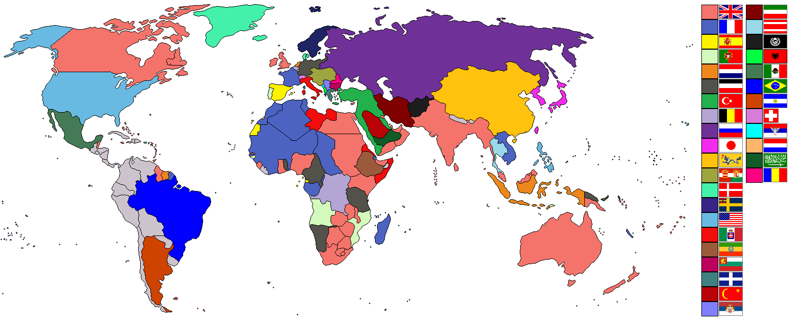
- 2007-08-02 22:04 Ishvara7 1554×627× (73211 bytes) *Ishvara7 *Taken from wikipedia map *Dated around 1900 *Nations involved with imperialism, directly or indirectly, are colored. Meant to potray the world around the time of WWI. *In case anyone wonders, the red flag with the yellow crescent and star is th
The original description page was here. All following user names refer to en.wikipedia.
- 2007-08-02 21:15 Ishvara7 1554×627× (72719 bytes) *Ishvara7 *Taken from wikipedia map *Not all nations are colored. Only ones with the most importance related to colonialism, interaction with colonial powers, and WWI. *Map dates to the year 1900.
The original description page was here. All following user names refer to en.wikipedia.
- 2007-08-02 19:27 Ishvara7 1554×627× (72762 bytes) *Ishvara7 *New nations labled according to importance within world politics and WWI. *Taken from old colonialism wikipedia map
The original description page was here. All following user names refer to en.wikipedia.
- 2007-08-01 01:36 Ishvara7 1458×627× (63275 bytes) *Ishvara7 *Taken from old colonial map on wikipeia and outlined *Better images of flags and includes Ethiopian Empire *yes, it did take forever
مێژووی پەڕگە
کرتە بکە لەسەر یەکێک لە ڕێکەوت/کاتەکان بۆ بینینی پەڕگەکە بەو شێوەی لەو کاتەدا بووە.
| ڕێکەوت/کات | ھێما | ئەندازە | بەکارھێنەر | تێبینی | |
|---|---|---|---|---|---|
| هەنووکە | ٠٩:٠٩، ٨ی تشرینی دووەمی ٢٠٢١ | ١٬٥٥٤ لە ٦٢٧ (٦٣ کیلۆبایت) | Randomastwritter | ogaden | |
| ٠٢:٤٨، ٥ی کانوونی یەکەمی ٢٠١٢ | ١٬٥٥٤ لە ٦٢٧ (٣٧ کیلۆبایت) | OjdvQ9fNJWl | Uploaded optimized image of first version here at Commons (latest on Wikipedia). File desc for prev version: *Ishvara7 *Taken from wikipedia map *Not all nations are colored. Only ones with the most importance related to colonialism, interaction with c... | ||
| ٠٢:٤٢، ٥ی کانوونی یەکەمی ٢٠١٢ | ١٬٥٥٤ لە ٦٢٧ (٧١ کیلۆبایت) | OjdvQ9fNJWl | Old version from Wikipedia (File:Imperialism.png) dated 21:15, 2 August 2007 by Ishvara7. File desc for prev: *New nations labled according to importance within world politics and WWI. *Taken from old colonialism wikipedia map. | ||
| ٠٢:٢٩، ٥ی کانوونی یەکەمی ٢٠١٢ | ١٬٥٥٤ لە ٦٢٧ (٧١ کیلۆبایت) | OjdvQ9fNJWl | Old version (File:Imperialism6.png) from Wikipedia by Ishvara7 at 19:27, 2 August 2007. File desc for prev upload: *Taken from old colonial map on wikipeia and outlined *Better images of flags and includes Ethiopian Empire *yes, it did take forever. Fi... | ||
| ٠٢:٢٥، ٥ی کانوونی یەکەمی ٢٠١٢ |  | ١٬٤٥٨ لە ٦٢٧ (٦٢ کیلۆبایت) | OjdvQ9fNJWl | Uploaded old image version from http://en.wikipedia.org/wiki/File:Imperialism_5.png uploaded by Ishvara7 at 01:36, 1 August 2007 (UTC) | |
| ٠٢:٠٣، ٥ی کانوونی یەکەمی ٢٠١٢ | ١٬٥٥٤ لە ٦٢٧ (٧١ کیلۆبایت) | OjdvQ9fNJWl | {{Information |Description={{en|*Taken from wikipedia map. *Dated around 1900 (shows Italian - although the flag is not correct - North Africa post 1910 and Austro-Hungarian Empire circa WW1). British territories o... |
بەکارھێنانی پەڕگە
ئەم پەڕەی 4ە ئەم پەڕگەیە بەکار دەھێنێت:
بەکارھێنانی سەرانسەریی پەڕگە
ئەم ویکیانەی دیکەی خوارەوەش ئەم پەڕگە بەکاردێنن:
- بەکارھێنان لە ar.wikipedia.org
- بەکارھێنان لە bs.wikipedia.org
- بەکارھێنان لە en.wikipedia.org
- بەکارھێنان لە fr.wikipedia.org
- بەکارھێنان لە km.wikipedia.org
- بەکارھێنان لە pnb.wikipedia.org
- بەکارھێنان لە ur.wikipedia.org