پەڕگە:MANCHURIA-U.S.S.R BOUNDARY Ct002999.jpg
قەبارەی ئەم پێشبینینە: ٧٨٤ لە ٥٩٩ پیکسەڵ. ڕێزەلووشنەکانی تر: ٣١٤ لە ٢٤٠ پیکسەڵ | ٦٢٨ لە ٤٨٠ پیکسەڵ | ١٬٠٠٥ لە ٧٦٨ پیکسەڵ | ١٬٢٨٠ لە ٩٧٨ پیکسەڵ | ٢٬٥٦٠ لە ١٬٩٥٧ پیکسەڵ | ٤٬١٦٧ لە ٣٬١٨٥ پیکسەڵ.
پەڕگەی سەرەکی (٤٬١٦٧ × ٣٬١٨٥ پیکسڵ، قەبارەی پەڕگە: ٤٫٢٥ مێگابایت، جۆری ئێم ئای ئێم ئی: image/jpeg)
کورتە
| وەسف |
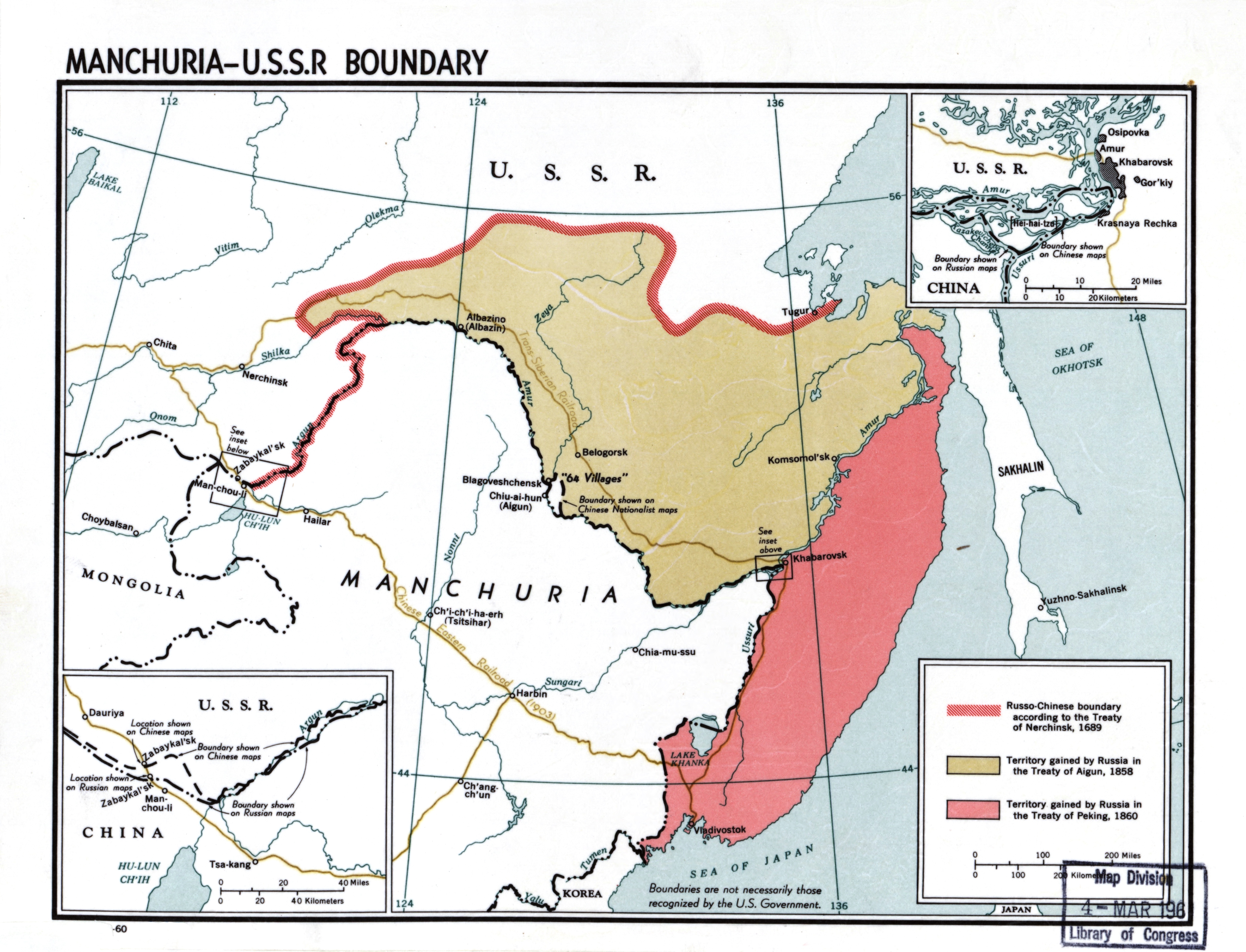
English: Manchuria-U.S.S.R. boundary |
| ڕێکەوت | |
| سەرچاوە |
Library of Congress Geography and Map Division Washington, D.C. 20540-4650 USA DIGITAL ID g7822m ct002999 http://hdl.loc.gov/loc.gmd/g7822m.ct002999 |
| بەرھەمھێنەر | CIA |
مۆڵەتنامە
| This image is a work of a Central Intelligence Agency employee, taken or made as part of that person's official duties. As a Work of the United States Government, this image or media is in the public domain in the United States.
|

|
مێژووی پەڕگە
کرتە بکە لەسەر یەکێک لە ڕێکەوت/کاتەکان بۆ بینینی پەڕگەکە بەو شێوەی لەو کاتەدا بووە.
| ڕێکەوت/کات | ھێما | ئەندازە | بەکارھێنەر | تێبینی | |
|---|---|---|---|---|---|
| هەنووکە | ٢٠:٥٠، ٢٣ی تشرینی دووەمی ٢٠٢٠ | | ٤٬١٦٧ لە ٣٬١٨٥ (٤٫٢٥ مێگابایت) | Gryffindor | {{Information |Description= |Source= |Date= |Author= |Permission= |other_versions= }} |
| ١٤:٥٣، ٢٢ی شوباتی ٢٠١٤ |  | ٤٬١٦٧ لە ٣٬١٨٥ (٦٫٢٢ مێگابایت) | Viktoria Kunst | User created page with UploadWizard |
بەکارھێنانی پەڕگە
ئەم پەڕەیە ئەم پەڕگەیە بەکار دەھێنێت:
بەکارھێنانی سەرانسەریی پەڕگە
ئەم ویکیانەی دیکەی خوارەوەش ئەم پەڕگە بەکاردێنن:
- بەکارھێنان لە af.wikipedia.org
- بەکارھێنان لە ar.wikipedia.org
- بەکارھێنان لە az.wikipedia.org
- بەکارھێنان لە bn.wikipedia.org
- بەکارھێنان لە ca.wikipedia.org
- بەکارھێنان لە cs.wikipedia.org
- بەکارھێنان لە da.wikipedia.org
- بەکارھێنان لە de.wikipedia.org
- بەکارھێنان لە en.wikipedia.org
- Manchuria
- History of Manchuria
- Treaty of Aigun
- Treaty of Nerchinsk
- Outer Manchuria
- Territorial evolution of Russia
- Sixty-Four Villages East of the River
- Bolshoy Ussuriysky Island
- Sino-Russian border conflicts
- Amur Annexation
- China–Russia relations
- China–Russia border
- Russia in the Opium Wars
- Timeline of the Qing dynasty
- User:Falcaorib
- Soviet deportations of Chinese people
- User:HNlander/Deportation of Chinese in the Soviet Union
- بەکارھێنان لە en.wiktionary.org
- بەکارھێنان لە es.wikipedia.org
- بەکارھێنان لە fa.wikipedia.org
- بەکارھێنان لە fi.wikipedia.org
- بەکارھێنان لە fr.wikipedia.org
بینینی بەکارھێنانی گشتی زیاتری ئەم پەڕگەیە.