پەڕگە:USA Territorial Growth small.gif
رەزۆلوشنی سەرتر لەمە لە بەردەست دا نیە.
USA_Territorial_Growth_small.gif (٤٣١ × ٢٨٧ پیکسڵ، قەبارەی پەڕگە: ٤٥٦ کیلۆبایت، جۆری ئێم ئای ئێم ئی: image/gif، looped، ١٠ frames، ٣٠چ)

|
This file has been superseded by USA territorial growth.gif. It is recommended to use the other file. Please note that deleting superseded images requires consent.
|

|
کورتە
| وەسف |
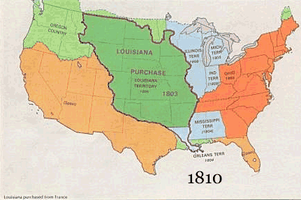
English: US territorial growth 1810–1920, based on the PD USGS maps in Category:Territorial growth maps of the United States.
See key below for explanation of colors.  |
||||||
| سەرچاوە |
|
||||||
| بەرھەمھێنەر |
|
||||||
| وەشانەکانی تر |
|
مۆڵەتنامە
This image is in the public domain in the United States because it only contains materials that originally came from the United States Geological Survey, an agency of the United States Department of the Interior. For more information, see the official USGS copyright policy.
|
مێژووی پەڕگە
کرتە بکە لەسەر یەکێک لە ڕێکەوت/کاتەکان بۆ بینینی پەڕگەکە بەو شێوەی لەو کاتەدا بووە.
| ڕێکەوت/کات | ھێما | ئەندازە | بەکارھێنەر | تێبینی | |
|---|---|---|---|---|---|
| هەنووکە | ١٠:٥٠، ٣٠ی ئایاری ٢٠٠٦ | | ٤٣١ لە ٢٨٧ (٤٥٦ کیلۆبایت) | Roke~commonswiki | US territorial growth, based on the PD USGS maps in Category:USA Territorial Growth Maps Category: USA Territorial Growth Maps {{PD-USGov-USGS}} |
بەکارھێنانی پەڕگە
ئەم پەڕەیە ئەم پەڕگەیە بەکار دەھێنێت:
بەکارھێنانی سەرانسەریی پەڕگە
ئەم ویکیانەی دیکەی خوارەوەش ئەم پەڕگە بەکاردێنن:
- بەکارھێنان لە ar.wikipedia.org
- بەکارھێنان لە be-tarask.wikipedia.org
- بەکارھێنان لە be.wikipedia.org
- بەکارھێنان لە ca.wikipedia.org
- بەکارھێنان لە da.wikipedia.org
- بەکارھێنان لە fr.wikipedia.org
- بەکارھێنان لە fy.wikipedia.org
- بەکارھێنان لە gcr.wikipedia.org
- بەکارھێنان لە hr.wikipedia.org
- بەکارھێنان لە id.wikipedia.org
- بەکارھێنان لە it.wikipedia.org
- بەکارھێنان لە jv.wikipedia.org
- بەکارھێنان لە kk.wikipedia.org
- بەکارھێنان لە ro.wikipedia.org
- بەکارھێنان لە sh.wikipedia.org
- بەکارھێنان لە sl.wikipedia.org
- بەکارھێنان لە sr.wikipedia.org
- بەکارھێنان لە tr.wikipedia.org
- بەکارھێنان لە uk.wikipedia.org