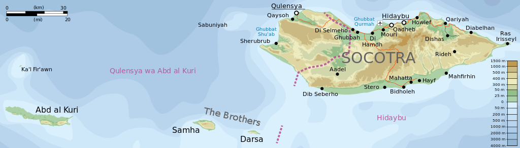
پەڕگە:Topographic map of the districts of Socotra (en).svg

Size of this PNG preview of this SVG file: ٨٠٠ لە ٢٢٩ پیکسەڵ. ڕێزەلووشنەکانی تر: ٣٢٠ لە ٩٢ پیکسەڵ | ٦٤٠ لە ١٨٣ پیکسەڵ | ١٬٠٢٤ لە ٢٩٣ پیکسەڵ | ١٬٢٨٠ لە ٣٦٧ پیکسەڵ | ٢٬٥٦٠ لە ٧٣٣ پیکسەڵ | ١٬٣٠٩ لە ٣٧٥ پیکسەڵ.
پەڕگەی سەرەکی (پەڕگەی SVG، بە ناو ١٬٣٠٩ × ٣٧٥ پیکسەڵ، قەبارەی پەڕگە: ٤١٢ کیلۆبایت)
.svg)
کورتە
| وەسف |
English: Topographic map of the districts of Socotra.
Deutsch: Topographische Karte der Distrikte von Sokotra.
Français : Carte topographique des départements de Socotra.
Македонски: Топографска карта на Сокотра.
Suomi: Sokotran topografinen kartta.
Русский: Топографическая карта Сокотры |
| ڕێکەوت | see file history |
| سەرچاوە |
Self-made in Inkscape. |
| بەرھەمھێنەر | Oona Räisänen (Mysid) |
| وەشانەکانی تر |
Derivative works of this file: |
.svg)
.svg)
|
This SVG file contains embedded text that can be translated into your language, using any capable SVG editor, text editor or the SVG Translate tool. For more information see: About translating SVG files. |
.svg)
مۆڵەتنامە
من، ھەڵگری مافی لەبەرگرتنەوەی ئەم بەرھەمە، لەژێر ئەم مۆڵەتنامەیانەدا بڵاوی دەکەمەوە:

|
ڕێگەدراوە بە لەبەرگرتنەوە، دابەشکردن ھەروەھا/یان سازاندنی ئەم بەڵگەنامەیە لەژێر مەرجی مۆڵەتی GNU بۆ بەڵگەنامەی ئازاد، وەشانی ١.٢ یان ھەر وەشانێکی تری دواتر کە بڵاوکراوەتەوە لەلایەن دامەزراوەی بەرنامەی ئازاد، بەبێ ھیچ بەشێکی جیاواز، بەبێ نووسین لەسەر بەرگی پێشەوە و دواوەی. وێنەیەک لەمۆڵەتەکە لە بەشێکدا ھەیە کە ناوی مۆڵەتی GNU بۆ بەڵگەنامەی ئازادە. |
This file is licensed under the Creative Commons Attribution-Share Alike 4.0 International, 3.0 Unported, 2.5 Generic, 2.0 Generic and 1.0 Generic license.
- تۆ ئازادی:
- بۆ بڵاکردنەوە – بۆ کۆپی کردن، دابەشکردن و دەستبەدەست ناردنی
- بۆ تێکەڵکردنەوە – بۆ سازاندنی کارەکە
- بەم مەرجانەی خوارەوە:
- دانەپاڵ – پێویستە باوەڕی گونجاو بدەیت، بەستەرێک بۆ مۆڵەتەکە دابین بکەیت و ئاماژە بەوە بکەیت کە ئایا گۆڕانکاری کراوە یان نا. دەتوانیت بە هەر شێوەیەکی گونجاو ئەوە بکەیت، بەڵام بە شێوەیەک نا کە وا دەربکەوێت کە مۆڵەتدەر پشتگیری تۆ یان بەکارهێنانەکەت بکات.
- بڵاوکردنەوەی گونجاو – ئەگەر لەسەر بنەمای ئەم کارە تێکەڵ، گۆڕان، یان ساز بکەی، پێویستە بەشدارییەکانت بە هەمان مۆڵەت یان هاوشێوەی مۆڵەتی ئەسڵی دابەش بکەی.
دەتوانی مۆڵەتنامەی دڵخوازت ھەڵبژێریت.
مێژووی پەڕگە
کرتە بکە لەسەر یەکێک لە ڕێکەوت/کاتەکان بۆ بینینی پەڕگەکە بەو شێوەی لەو کاتەدا بووە.
| ڕێکەوت/کات | ھێما | ئەندازە | بەکارھێنەر | تێبینی | |
|---|---|---|---|---|---|
| هەنووکە | ٢٠:٣١، ٢٨ی ئابی ٢٠١٤ | ١٬٣٠٩ لە ٣٧٥ (٤١٢ کیلۆبایت) | Chumwa | ||
| ٢٠:٢٧، ٢٧ی ئابی ٢٠١٤ | ١٬٣٠٩ لە ٣٧٥ (٤١٢ کیلۆبایت) | Chumwa | |||
| ٢٠:٠٧، ٢٧ی ئابی ٢٠١٤ | ١٬٣٠٩ لە ٣٧٥ (٤١٣ کیلۆبایت) | Chumwa | == {{int:filedesc}} == {{Information |Description= {{en|Topographic map of the districts of Socotra.}} {{de|Topographische Karte der Distrikte von Sokotra.}} {{fr|Carte topographique des départements de [[:fr:Socotra|So... |
بەکارھێنانی پەڕگە
ئەم پەڕەیە ئەم پەڕگەیە بەکار دەھێنێت:
بەکارھێنانی سەرانسەریی پەڕگە
ئەم ویکیانەی دیکەی خوارەوەش ئەم پەڕگە بەکاردێنن:
- بەکارھێنان لە ar.wikipedia.org
- بەکارھێنان لە arz.wikipedia.org
- بەکارھێنان لە bg.wikipedia.org
- بەکارھێنان لە bn.wikipedia.org
- بەکارھێنان لە de.wikipedia.org
- بەکارھێنان لە en.wikipedia.org
- بەکارھێنان لە es.wikipedia.org
- بەکارھێنان لە fa.wikipedia.org
- بەکارھێنان لە fr.wikipedia.org
- بەکارھێنان لە ja.wikipedia.org
- بەکارھێنان لە kk.wikipedia.org
- بەکارھێنان لە mt.wikipedia.org
- بەکارھێنان لە nn.wikipedia.org
- بەکارھێنان لە ru.wikipedia.org
- بەکارھێنان لە si.wikipedia.org
- بەکارھێنان لە uk.wikipedia.org
- بەکارھێنان لە ur.wikipedia.org
- بەکارھێنان لە vi.wikipedia.org
- بەکارھێنان لە www.wikidata.org
- بەکارھێنان لە zh.wikipedia.org
.svg)