پەڕگە:St. John, U.S. Virgin Islands.jpg

قەبارەی ئەم پێشبینینە: ٦٠٠ لە ٦٠٠ پیکسەڵ. ڕێزەلووشنەکانی تر: ٢٤٠ لە ٢٤٠ پیکسەڵ | ٤٨٠ لە ٤٨٠ پیکسەڵ | ٧٦٨ لە ٧٦٨ پیکسەڵ | ١٬٠٢٤ لە ١٬٠٢٤ پیکسەڵ | ٢٬٤٠٠ لە ٢٬٤٠٠ پیکسەڵ.
پەڕگەی سەرەکی (٢٬٤٠٠ × ٢٬٤٠٠ پیکسڵ، قەبارەی پەڕگە: ٢٫٧٤ مێگابایت، جۆری ئێم ئای ئێم ئی: image/jpeg)
کورتە
| وەسف |
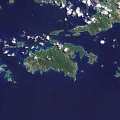
English: Natural-colour image of the Island of St. John island in the United States Virgin Islands.
|
| ڕێکەوت | |
| سەرچاوە | NASA Earth Observatory |
| بەرھەمھێنەر | Jesse Allen and Robert Simmon |
| وەشانەکانی تر |


.jpg)

Image captured by the Advanced Land Imager (ALI) on NASA’s Earth Observing-1 (EO-1) satellite. EO-1 ALI data provided courtesy of the NASA EO-1 team.
مۆڵەتنامە
| This file is in the public domain in the United States because it was solely created by NASA. NASA copyright policy states that "NASA material is not protected by copyright unless noted". (See Template:PD-USGov, NASA copyright policy page or JPL Image Use Policy.) | ||
 |
Warnings:
|
| Annotations | This image is annotated: View the annotations at Commons |
مێژووی پەڕگە
کرتە بکە لەسەر یەکێک لە ڕێکەوت/کاتەکان بۆ بینینی پەڕگەکە بەو شێوەی لەو کاتەدا بووە.
| ڕێکەوت/کات | ھێما | ئەندازە | بەکارھێنەر | تێبینی | |
|---|---|---|---|---|---|
| هەنووکە | ١٠:١٣، ٢٠ی کانوونی دووەمی ٢٠١١ | | ٢٬٤٠٠ لە ٢٬٤٠٠ (٢٫٧٤ مێگابایت) | Originalwana | {{Information |Description={{en|1=Natural-colour image of the eastern half of St. John. Settlements—marked by curving roads and light roofs—line the irregular coastline. The pinpoints of white in Coral Bay are probably boats. The island’s interior |
بەکارھێنانی پەڕگە
ئەم پەڕەیە ئەم پەڕگەیە بەکار دەھێنێت:
بەکارھێنانی سەرانسەریی پەڕگە
ئەم ویکیانەی دیکەی خوارەوەش ئەم پەڕگە بەکاردێنن:
- بەکارھێنان لە arz.wikipedia.org
- بەکارھێنان لە ast.wikipedia.org
- بەکارھێنان لە ca.wikipedia.org
- بەکارھێنان لە ceb.wikipedia.org
- بەکارھێنان لە de.wikivoyage.org
- بەکارھێنان لە en.wikipedia.org
- بەکارھێنان لە en.wikisource.org
- بەکارھێنان لە eo.wikipedia.org
- بەکارھێنان لە eo.wikinews.org
- بەکارھێنان لە es.wikipedia.org
- بەکارھێنان لە eu.wikipedia.org
- بەکارھێنان لە fi.wikipedia.org
- بەکارھێنان لە frr.wikipedia.org
- بەکارھێنان لە fr.wikivoyage.org
- بەکارھێنان لە ga.wikipedia.org
- بەکارھێنان لە gl.wikipedia.org
- بەکارھێنان لە id.wikipedia.org
- بەکارھێنان لە ja.wikipedia.org
- بەکارھێنان لە lb.wikipedia.org
- بەکارھێنان لە pl.wikipedia.org
- بەکارھێنان لە tg.wikipedia.org
- بەکارھێنان لە tl.wikipedia.org
- بەکارھێنان لە tt.wikipedia.org
- بەکارھێنان لە uk.wikipedia.org
- بەکارھێنان لە vec.wikipedia.org
- بەکارھێنان لە www.wikidata.org