پەڕگە:South asia.jpg
رەزۆلوشنی سەرتر لەمە لە بەردەست دا نیە.
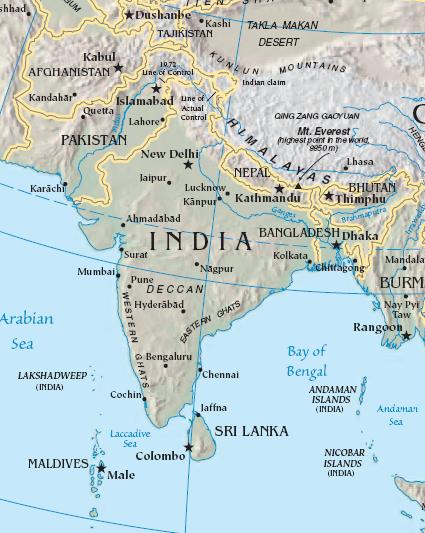
South_asia.jpg (٤٢٥ × ٥٣٣ پیکسڵ، قەبارەی پەڕگە: ٥٢ کیلۆبایت، جۆری ئێم ئای ئێم ئی: image/jpeg)
کورتە
| وەسف |
Import from File:South asia.jpg 26 July 2008 English: The image is cropped from en:Image:Sino-Indian Geography.png, created and published by the en:Central Intelligence Agency of the en:United States of America in en:2004.
NoteThis map represents the en:line of control in en:Kashmir as the international border between the en:Republic of India and en:Islamic Republic of Pakistan, a position considered unacceptable to either party. |
| سەرچاوە | CIA World Factbook |
| بەرھەمھێنەر | CIA |

|
This map image could be re-created using vector graphics as an SVG file. This has several advantages; see Commons:Media for cleanup for more information. If an SVG form of this image is available, please upload it and afterwards replace this template with
{{vector version available|new image name}}.
It is recommended to name the SVG file “South asia.svg”—then the template Vector version available (or Vva) does not need the new image name parameter. |


مۆڵەتنامە
This image is in the public domain because it contains materials that originally came from the United States Central Intelligence Agency's World Factbook.
|
 |
Original upload log
The original description page was here. All following user names refer to en.wikipedia.
- 2003-10-28 08:22 Mkweise 421×541×8 (88052 bytes) cropped from PD image
مێژووی پەڕگە
کرتە بکە لەسەر یەکێک لە ڕێکەوت/کاتەکان بۆ بینینی پەڕگەکە بەو شێوەی لەو کاتەدا بووە.
| ڕێکەوت/کات | ھێما | ئەندازە | بەکارھێنەر | تێبینی | |
|---|---|---|---|---|---|
| هەنووکە | ١٦:٥٩، ٦ی ئابی ٢٠٠٨ | | ٤٢٥ لە ٥٣٣ (٥٢ کیلۆبایت) | Deepak~commonswiki | |
| ٠٠:٤٨، ٢٧ی تەممووزی ٢٠٠٨ |  | ٤٢١ لە ٥٤١ (٨٦ کیلۆبایت) | File Upload Bot (Magnus Manske) | {{BotMoveToCommons|en.wikipedia}} {{Information |Description={{en|<small>The image is cropped from en::Image:Sino-Indian Geography.png, created and published by the en:Central Intelligence Agency of the en:United States of America in [[:en |
بەکارھێنانی پەڕگە
ھیچ پەڕەیەک نییە کە ئەم پەڕگەیە بەکاربھێنێت.
بەکارھێنانی سەرانسەریی پەڕگە
ئەم ویکیانەی دیکەی خوارەوەش ئەم پەڕگە بەکاردێنن:
- بەکارھێنان لە ace.wikipedia.org
- بەکارھێنان لە ar.wikipedia.org
- بەکارھێنان لە ast.wikipedia.org
- بەکارھێنان لە bg.wikipedia.org
- بەکارھێنان لە bs.wikipedia.org
- بەکارھێنان لە cy.wikipedia.org
- بەکارھێنان لە en.wikipedia.org
- بەکارھێنان لە es.wikipedia.org
- بەکارھێنان لە id.wikipedia.org
- بەکارھێنان لە incubator.wikimedia.org
- بەکارھێنان لە jv.wikipedia.org
- بەکارھێنان لە kn.wikipedia.org
- بەکارھێنان لە la.wikipedia.org
- بەکارھێنان لە ml.wikipedia.org
- بەکارھێنان لە ms.wikipedia.org
- بەکارھێنان لە pam.wikipedia.org
- بەکارھێنان لە pl.wiktionary.org
- بەکارھێنان لە pnb.wikipedia.org
- بەکارھێنان لە rmy.wikipedia.org
- بەکارھێنان لە ru.wikipedia.org
- بەکارھێنان لە sh.wikipedia.org
- بەکارھێنان لە simple.wikipedia.org
- بەکارھێنان لە sr.wikipedia.org
- بەکارھێنان لە sv.wikipedia.org
- بەکارھێنان لە ta.wikipedia.org
- بەکارھێنان لە te.wikipedia.org
- بەکارھێنان لە tl.wikipedia.org
- بەکارھێنان لە tr.wikipedia.org
- بەکارھێنان لە tr.wiktionary.org
- بەکارھێنان لە war.wikipedia.org
- بەکارھێنان لە www.wikidata.org
- بەکارھێنان لە zh.wikipedia.org
بینینی بەکارھێنانی گشتی زیاتری ئەم پەڕگەیە.