پەڕگە:Mughal Empire (orthographic projection).svg

Size of this PNG preview of this SVG file: ٥٤١ لە ٥٤١ پیکسەڵ. ڕێزەلووشنەکانی تر: ٢٤٠ لە ٢٤٠ پیکسەڵ | ٤٨٠ لە ٤٨٠ پیکسەڵ | ٧٦٨ لە ٧٦٨ پیکسەڵ | ١٬٠٢٤ لە ١٬٠٢٤ پیکسەڵ | ٢٬٠٤٨ لە ٢٬٠٤٨ پیکسەڵ.
پەڕگەی سەرەکی (پەڕگەی SVG، بە ناو ٥٤١ × ٥٤١ پیکسەڵ، قەبارەی پەڕگە: ٢١٧ کیلۆبایت)

.svg)
کورتە
| وەسف |
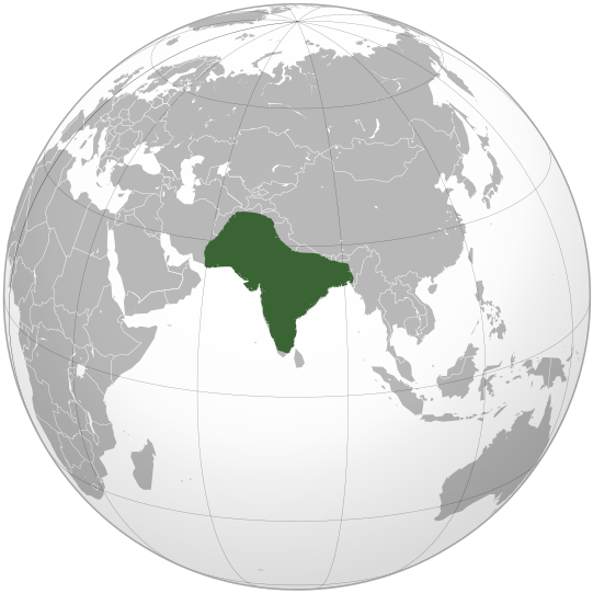
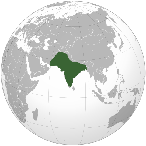
English: Location of Mughal Empire in the reign of Aurangzeb. |
| ڕێکەوت | |
| سەرچاوە | بەرھەمی خۆم |
| بەرھەمھێنەر | KarnRedsun |
مۆڵەتنامە
من، ھەڵگری مافی لەبەرگرتنەوەی ئەم بەرھەمە، لەژێر ئەم مۆڵەتنامەیانەدا بڵاوی دەکەمەوە:
ئەم پەڕگەیە لە ژێر مۆڵەتنامەی
Creative Commons Attribution-Share Alike 3.0 Unported دایە.
- تۆ ئازادی:
- بۆ بڵاکردنەوە – بۆ کۆپی کردن، دابەشکردن و دەستبەدەست ناردنی
- بۆ تێکەڵکردنەوە – بۆ سازاندنی کارەکە
- بەم مەرجانەی خوارەوە:
- دانەپاڵ – پێویستە باوەڕی گونجاو بدەیت، بەستەرێک بۆ مۆڵەتەکە دابین بکەیت و ئاماژە بەوە بکەیت کە ئایا گۆڕانکاری کراوە یان نا. دەتوانیت بە هەر شێوەیەکی گونجاو ئەوە بکەیت، بەڵام بە شێوەیەک نا کە وا دەربکەوێت کە مۆڵەتدەر پشتگیری تۆ یان بەکارهێنانەکەت بکات.
- بڵاوکردنەوەی گونجاو – ئەگەر لەسەر بنەمای ئەم کارە تێکەڵ، گۆڕان، یان ساز بکەی، پێویستە بەشدارییەکانت بە هەمان مۆڵەت یان هاوشێوەی مۆڵەتی ئەسڵی دابەش بکەی.

|
ڕێگەدراوە بە لەبەرگرتنەوە، دابەشکردن ھەروەھا/یان سازاندنی ئەم بەڵگەنامەیە لەژێر مەرجی مۆڵەتی GNU بۆ بەڵگەنامەی ئازاد، وەشانی ١.٢ یان ھەر وەشانێکی تری دواتر کە بڵاوکراوەتەوە لەلایەن دامەزراوەی بەرنامەی ئازاد، بەبێ ھیچ بەشێکی جیاواز، بەبێ نووسین لەسەر بەرگی پێشەوە و دواوەی. وێنەیەک لەمۆڵەتەکە لە بەشێکدا ھەیە کە ناوی مۆڵەتی GNU بۆ بەڵگەنامەی ئازادە. |
دەتوانی مۆڵەتنامەی دڵخوازت ھەڵبژێریت.
مێژووی پەڕگە
کرتە بکە لەسەر یەکێک لە ڕێکەوت/کاتەکان بۆ بینینی پەڕگەکە بەو شێوەی لەو کاتەدا بووە.
| ڕێکەوت/کات | ھێما | ئەندازە | بەکارھێنەر | تێبینی | |
|---|---|---|---|---|---|
| هەنووکە | ١٦:٢٩، ١٩ی کانوونی یەکەمی ٢٠١٩ | | ٥٤١ لە ٥٤١ (٢١٧ کیلۆبایت) | Goran tek-en | Added border for South Sudan as requested by {{u|Maphobbyist}} |
| ٠٩:١١، ١٧ی تشرینی یەکەمی ٢٠٠٩ |  | ٥٤١ لە ٥٤١ (٥٥٢ کیلۆبایت) | KarnRedsun | {{Information |Description={{en|1=Location of Mughal Empire in the reign of Aurangzeb.}} |Source={{own}} |Author=KarnRedsun |Date=2009-10-17 |Permission= |other_versions= }} Category:SVG - Orthographic projections [[Category:Maps |
بەکارھێنانی پەڕگە
ئەم پەڕەیە ئەم پەڕگەیە بەکار دەھێنێت:
بەکارھێنانی سەرانسەریی پەڕگە
ئەم ویکیانەی دیکەی خوارەوەش ئەم پەڕگە بەکاردێنن:
- بەکارھێنان لە el.wikipedia.org
- بەکارھێنان لە en.wikipedia.org
- بەکارھێنان لە es.wikipedia.org
- بەکارھێنان لە fa.wikipedia.org
- بەکارھێنان لە fr.wikipedia.org
- بەکارھێنان لە he.wikipedia.org
- بەکارھێنان لە id.wikipedia.org
- بەکارھێنان لە it.wikipedia.org
- بەکارھێنان لە it.wikivoyage.org
- بەکارھێنان لە ja.wikipedia.org
- بەکارھێنان لە jv.wikipedia.org
- بەکارھێنان لە ko.wikipedia.org
- بەکارھێنان لە ky.wikipedia.org
- بەکارھێنان لە mg.wikipedia.org
- بەکارھێنان لە ru.wikipedia.org
- بەکارھێنان لە sco.wikipedia.org
- بەکارھێنان لە tr.wikipedia.org
- بەکارھێنان لە vi.wikipedia.org
.svg)