پەڕگە:Mount Rainier 5917s.JPG

قەبارەی ئەم پێشبینینە: ٧٠٩ لە ٦٠٠ پیکسەڵ. ڕێزەلووشنەکانی تر: ٢٨٤ لە ٢٤٠ پیکسەڵ | ٥٦٧ لە ٤٨٠ پیکسەڵ | ٩٠٨ لە ٧٦٨ پیکسەڵ | ١٬٢١٠ لە ١٬٠٢٤ پیکسەڵ | ٢٬٤٢٠ لە ٢٬٠٤٨ پیکسەڵ | ٤٬٩٢٠ لە ٤٬١٦٣ پیکسەڵ.
پەڕگەی سەرەکی (٤٬٩٢٠ × ٤٬١٦٣ پیکسڵ، قەبارەی پەڕگە: ٤٫٩٥ مێگابایت، جۆری ئێم ئای ئێم ئی: image/jpeg)
| وەسف |
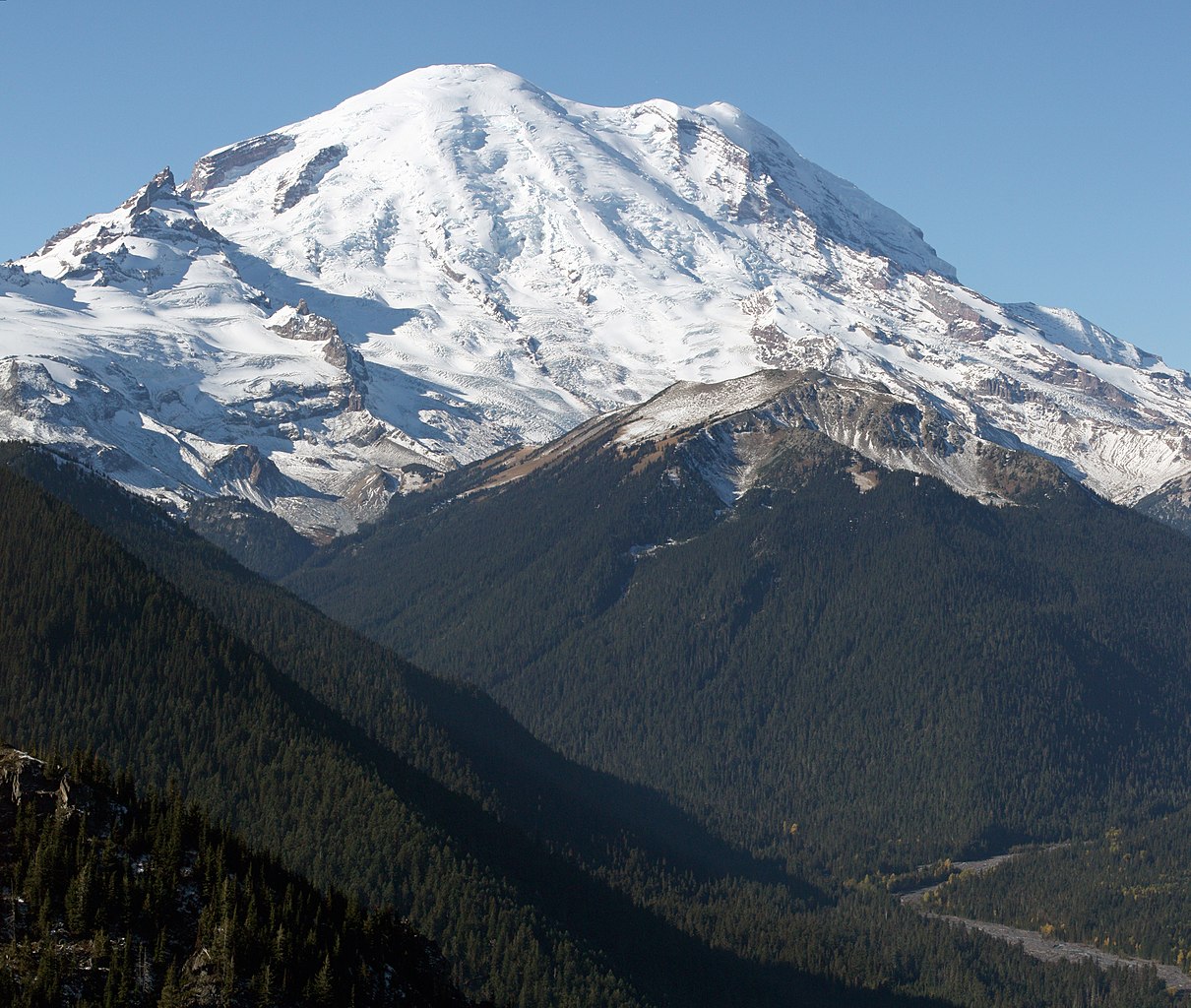
English: Mount Rainier with its main summit, Columbia Crest (14410 feet) at the center. Emmons Glacier covers most of the visible flank of the mountain. Ingraham Glacier (left) is between Gibraltar Rock (12660 feet) high on the left skyline and Disappointment Cleaver. Left of Gibraltar Rock is sharp pointed Little Tahoma (11138 feet) with Frying Pan Glacier on its flank. It is the source of Frying Pan Creek in the valley left of forested and rounded Goat Island Mountain, in front of the Emmons Glacier. Liberty Cap (14112 feet) is visible on the right center skyline behind Russell Cliff. Curtis Ridge descends to the right from Russell Cliff. Winthrop Glacier flows right below Curtis Ridge and behind shallow Steamboat Prow (9680 feet) with the small Inter Glacier on its northeast face. The White River comes from the Emmons Glacier and flows around the right side of Goat Island Mountain in the watercourse visible below right.
Esperanto: monto Rainier vidata de oriento |
| ڕێکەوت | ٢٢ی تشرینی یەکەمی ٢٠٠٨، ١١:١٩:١١ −٠٧:٠٠ |
| سەرچاوە | بەرھەمی خۆم |
| بەرھەمھێنەر | Walter Siegmund (talk) |
| وەشانەکانی تر |
|


| Camera location | | View this and other nearby images on: OpenStreetMap |
|---|
- Location source: Garmin GPSmap 60CSx
- Location Datum: WGS84
- Viewpoint location: Crystal Lakes Trail, Mount Rainier National Park
- Viewpoint elevation: 1732 meter (5684 ft)
- View direction: West-southwest
- Camera: Canon EOS DIGITAL REBEL XSi
- Exposure Time: 1/800
- F Number: f/11.0
- Focal Length: 70.0
- ISO Speed Rating: 400
This image was created with Hugin.
| This is a retouched picture, which means that it has been digitally altered from its original version. Modifications: Stitched two images; adjusted levels and color balance; please see other versions in the information template for the originals. Modifications made by Wsiegmund.
|
©2009 Walter Siegmund
مۆڵەتنامە
من، ھەڵگری مافی لەبەرگرتنەوەی ئەم بەرھەمە، لەژێر ئەم مۆڵەتنامەیانەدا بڵاوی دەکەمەوە:

|
ڕێگەدراوە بە لەبەرگرتنەوە، دابەشکردن ھەروەھا/یان سازاندنی ئەم بەڵگەنامەیە لەژێر مەرجی مۆڵەتی GNU بۆ بەڵگەنامەی ئازاد، وەشانی ١.٢ یان ھەر وەشانێکی تری دواتر کە بڵاوکراوەتەوە لەلایەن دامەزراوەی بەرنامەی ئازاد، بەبێ ھیچ بەشێکی جیاواز، بەبێ نووسین لەسەر بەرگی پێشەوە و دواوەی. وێنەیەک لەمۆڵەتەکە لە بەشێکدا ھەیە کە ناوی مۆڵەتی GNU بۆ بەڵگەنامەی ئازادە. |
This file is licensed under the Creative Commons Attribution-Share Alike 3.0 Unported, 2.5 Generic, 2.0 Generic and 1.0 Generic license.
- تۆ ئازادی:
- بۆ بڵاکردنەوە – بۆ کۆپی کردن، دابەشکردن و دەستبەدەست ناردنی
- بۆ تێکەڵکردنەوە – بۆ سازاندنی کارەکە
- بەم مەرجانەی خوارەوە:
- دانەپاڵ – پێویستە باوەڕی گونجاو بدەیت، بەستەرێک بۆ مۆڵەتەکە دابین بکەیت و ئاماژە بەوە بکەیت کە ئایا گۆڕانکاری کراوە یان نا. دەتوانیت بە هەر شێوەیەکی گونجاو ئەوە بکەیت، بەڵام بە شێوەیەک نا کە وا دەربکەوێت کە مۆڵەتدەر پشتگیری تۆ یان بەکارهێنانەکەت بکات.
- بڵاوکردنەوەی گونجاو – ئەگەر لەسەر بنەمای ئەم کارە تێکەڵ، گۆڕان، یان ساز بکەی، پێویستە بەشدارییەکانت بە هەمان مۆڵەت یان هاوشێوەی مۆڵەتی ئەسڵی دابەش بکەی.
دەتوانی مۆڵەتنامەی دڵخوازت ھەڵبژێریت.
مێژووی پەڕگە
کرتە بکە لەسەر یەکێک لە ڕێکەوت/کاتەکان بۆ بینینی پەڕگەکە بەو شێوەی لەو کاتەدا بووە.
| ڕێکەوت/کات | ھێما | ئەندازە | بەکارھێنەر | تێبینی | |
|---|---|---|---|---|---|
| هەنووکە | ٠٥:٢٧، ٢١ی ئازاری ٢٠٠٩ | | ٤٬٩٢٠ لە ٤٬١٦٣ (٤٫٩٥ مێگابایت) | Wsiegmund | Removed dust spots |
| ٠٤:٢٢، ١٣ی ئازاری ٢٠٠٩ |  | ٤٬٩٢٠ لە ٤٬١٦٣ (٤٫٩٥ مێگابایت) | Wsiegmund | {{Information |Description = {{en|Mount Rainier with its main summit, Columbia Crest (14410 feet) at the center. Emmons Glacier covers most of the visible flank of the mountain. Ingraham Glacier (left) is between Gibraltar Rock (12660 feet) high on th |
بەکارھێنانی پەڕگە
ئەم پەڕەیە ئەم پەڕگەیە بەکار دەھێنێت:
بەکارھێنانی سەرانسەریی پەڕگە
ئەم ویکیانەی دیکەی خوارەوەش ئەم پەڕگە بەکاردێنن:
- بەکارھێنان لە ar.wikipedia.org
- بەکارھێنان لە arz.wikipedia.org
- بەکارھێنان لە bn.wikipedia.org
- بەکارھێنان لە ca.wikipedia.org
- بەکارھێنان لە ceb.wikipedia.org
- بەکارھێنان لە cs.wikipedia.org
- بەکارھێنان لە de.wikipedia.org
- بەکارھێنان لە el.wikipedia.org
- بەکارھێنان لە en.wikipedia.org
- Pacific Northwest
- Dixy Lee Ray
- List of mountain peaks of North America
- List of National Historic Landmarks in Washington (state)
- List of the most isolated major summits of the United States
- Talk:Mount Rainier/Archive 1
- User talk:Hike395/Archive 10
- List of ultras of North America
- List of the most prominent summits of the United States
- List of the major 100-kilometer summits of North America
- Wikipedia:Teahouse/Guest book/Archive 1
- User:Ecpiandy/Washington (state)
- List of the highest major summits of North America
- List of the highest major summits of the United States
- بەکارھێنان لە en.wikiversity.org
- بەکارھێنان لە en.wikivoyage.org
- بەکارھێنان لە eo.wikipedia.org
- بەکارھێنان لە es.wikipedia.org
- بەکارھێنان لە es.wikivoyage.org
- بەکارھێنان لە et.wikipedia.org
- بەکارھێنان لە eu.wikipedia.org
- بەکارھێنان لە frr.wikipedia.org
- بەکارھێنان لە fr.wikipedia.org
- Mont Saint Helens
- Mont Rainier
- Mont Shasta
- Chaîne des Cascades
- Mont Hood
- Mont Adams
- Mont Baker
- Pic Glacier
- Three Sisters (Oregon)
- Pic Lassen
- Medicine Lake (volcan)
- Mont Washington (Oregon)
- Wikipédia:Lumière sur/Mai 2008
- Wikipédia:Lumière sur/Mont Rainier
- Wikipédia:Sélection/Géographie
- Wikipédia:Sélection/Volcanisme
- Mont Thielsen
بینینی بەکارھێنانی گشتی زیاتری ئەم پەڕگەیە.