پەڕگە:MiyazakiMapCurrent.png

قەبارەی ئەم پێشبینینە: ٥٣٣ لە ٦٠٠ پیکسەڵ. ڕێزەلووشنەکانی تر: ٢١٣ لە ٢٤٠ پیکسەڵ | ٤٢٧ لە ٤٨٠ پیکسەڵ | ٨٠١ لە ٩٠١ پیکسەڵ.
پەڕگەی سەرەکی (٨٠١ × ٩٠١ پیکسڵ، قەبارەی پەڕگە: ٣٠ کیلۆبایت، جۆری ئێم ئای ئێم ئی: image/png)

|
This locator map image could be re-created using vector graphics as an SVG file. This has several advantages; see Commons:Media for cleanup for more information. If an SVG form of this image is available, please upload it and afterwards replace this template with
{{vector version available|new image name}}.
It is recommended to name the SVG file “MiyazakiMapCurrent.svg”—then the template Vector version available (or Vva) does not need the new image name parameter. |
کورتە
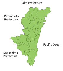
Map of Miyazaki Prefecture, Japan.
Thanks to Aoki Shigenobu and [1]. Colors from Image:TokyoMapCurrent.png by User:Fg2.
مۆڵەتنامە
| من، هەڵگری مافی لەبەرگرتنەوەی ئەم بەرھەمە، ئەم بەرھەمە بڵاودەکەمەوە بۆ پاوانی گشتی (public domain). ئەم مافە بۆ سەرانسەری جیھانە. لە ھەندێ وڵاتدا لەوانەیە یاسا، ڕێگە بەمە نەدات؛ لەو کاتەدا: من مافی بەکارھێنانی ئەم بەرھەمە بۆ ھەر مەبەستێک دەبەخشم بە ھەموو کەسێک، بێ ھیچ مەرجێک، مەگەر ئەو چەشنە مەرجانە کە یاسا ھەبوونیانی بە پێویستی بزانێت. |
مێژووی پەڕگە
کرتە بکە لەسەر یەکێک لە ڕێکەوت/کاتەکان بۆ بینینی پەڕگەکە بەو شێوەی لەو کاتەدا بووە.
| ڕێکەوت/کات | ھێما | ئەندازە | بەکارھێنەر | تێبینی | |
|---|---|---|---|---|---|
| هەنووکە | ١٩:٢٤، ٢٢ی ئازاری ٢٠١٠ | | ٨٠١ لە ٩٠١ (٣٠ کیلۆبایت) | Alberth2 | Nojiri Town was mereged into Kobayashi City and Kiyotake Town was mereged into Miyazaki City. |
| ٠٨:٠١، ٣١ی ئازاری ٢٠٠٩ |  | ٨٠١ لە ٩٠١ (٣١ کیلۆبایت) | Alberth2 | Nangou-chō, Kitagou-chō and Nichinan-shi were megred. | |
| ٠٧:٣٤، ٢٦ی ئەیلوولی ٢٠٠٨ |  | ٨٠١ لە ٩٠١ (٣١ کیلۆبایت) | Alberth2 | Kitagawa was merged into Nobeoka. | |
| ٢٣:٥٩، ٢٣ی تەممووزی ٢٠٠٦ |  | ٨٠١ لە ٩٠١ (٣٠ کیلۆبایت) | Akanemoto~commonswiki | ||
| ١٥:٤٧، ٢٢ی تەممووزی ٢٠٠٦ |  | ٨٠١ لە ٩٠١ (٣١ کیلۆبایت) | Akanemoto~commonswiki | ||
| ٠٢:٠٠، ٢٢ی تەممووزی ٢٠٠٦ |  | ٨٠١ لە ٩٠١ (٣١ کیلۆبایت) | Akanemoto~commonswiki | ||
| ٢١:٢٥، ٢١ی تەممووزی ٢٠٠٦ |  | ٩٨١ لە ٩٠١ (٣٢ کیلۆبایت) | Akanemoto~commonswiki | Map of Miyazaki Prefecture, Japan. Thanks to Aoki Shigenobu and [http://aoki2.si.gunma-u.ac.jp/map/map.html]. Colors from Image:TokyoMapCurrent.png by User:Fg2. Category:Maps of Miyazaki prefecture Category:Maps in English |
بەکارھێنانی پەڕگە
ئەم پەڕەیە ئەم پەڕگەیە بەکار دەھێنێت:
بەکارھێنانی سەرانسەریی پەڕگە
ئەم ویکیانەی دیکەی خوارەوەش ئەم پەڕگە بەکاردێنن:
- بەکارھێنان لە az.wikipedia.org
- بەکارھێنان لە cs.wikipedia.org
- بەکارھێنان لە fa.wikipedia.org
- بەکارھێنان لە fr.wikipedia.org
- بەکارھێنان لە ilo.wikipedia.org
- بەکارھێنان لە incubator.wikimedia.org
- بەکارھێنان لە lt.wikipedia.org
- بەکارھێنان لە ms.wikipedia.org
- بەکارھێنان لە no.wikipedia.org
- بەکارھێنان لە pam.wikipedia.org
- بەکارھێنان لە pl.wikipedia.org
- بەکارھێنان لە ru.wikipedia.org
- بەکارھێنان لە sah.wikipedia.org
- بەکارھێنان لە su.wikipedia.org
- بەکارھێنان لە vi.wikipedia.org