پەڕگە:India in 350 CE Joppen.jpg

قەبارەی ئەم پێشبینینە: ٤١٠ لە ٥٩٩ پیکسەڵ. ڕێزەلووشنەکانی تر: ١٦٤ لە ٢٤٠ پیکسەڵ | ٣٢٨ لە ٤٨٠ پیکسەڵ | ٥٢٥ لە ٧٦٨ پیکسەڵ | ٧٠٠ لە ١٬٠٢٤ پیکسەڵ | ١٬٤٠١ لە ٢٬٠٤٨ پیکسەڵ | ٢٬٦٣٠ لە ٣٬٨٤٥ پیکسەڵ.
پەڕگەی سەرەکی (٢٬٦٣٠ × ٣٬٨٤٥ پیکسڵ، قەبارەی پەڕگە: ٢٫٦٤ مێگابایت، جۆری ئێم ئای ئێم ئی: image/jpeg)
کورتە
| وەسف | |
| ڕێکەوت | |
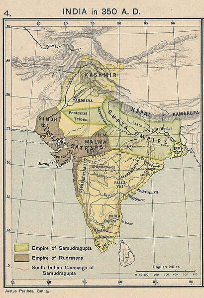
| سەرچاوە | From a personal copy of A Historical Atlas of India by Charles Joppen SJ, London: Longman Greens, 1907 Fowler&fowler (لێدوان) 20:52, 20 August 2019 (UTC) |
| بەرھەمھێنەر | Justus Perthes, Gotha, 1907 |
مۆڵەتنامە
|
This work is in the public domain in its country of origin and other countries and areas where the copyright term is the author's life plus 70 years or fewer. This work is in the public domain in the United States because it was published (or registered with the U.S. Copyright Office) before January 1, 1929. | |
| This file has been identified as being free of known restrictions under copyright law, including all related and neighboring rights. | |
مێژووی پەڕگە
کرتە بکە لەسەر یەکێک لە ڕێکەوت/کاتەکان بۆ بینینی پەڕگەکە بەو شێوەی لەو کاتەدا بووە.
| ڕێکەوت/کات | ھێما | ئەندازە | بەکارھێنەر | تێبینی | |
|---|---|---|---|---|---|
| هەنووکە | ٢٠:٥٢، ٢٠ی ئابی ٢٠١٩ | | ٢٬٦٣٠ لە ٣٬٨٤٥ (٢٫٦٤ مێگابایت) | Fowler&fowler | User created page with UploadWizard |
بەکارھێنانی پەڕگە
ئەم پەڕەیە ئەم پەڕگەیە بەکار دەھێنێت:
بەکارھێنانی سەرانسەریی پەڕگە
ئەم ویکیانەی دیکەی خوارەوەش ئەم پەڕگە بەکاردێنن:
- بەکارھێنان لە ar.wikipedia.org
- بەکارھێنان لە en.wikipedia.org
- بەکارھێنان لە hy.wikipedia.org
- بەکارھێنان لە ro.wikipedia.org