پەڕگە:India Punjab locator map.svg

پەڕگەی سەرەکی (پەڕگەی SVG، بە ناو ١٬٥٧٤ × ١٬٧٣٨ پیکسەڵ، قەبارەی پەڕگە: ٨٣٦ کیلۆبایت)

|
This file requires updating because: Newly-created Fazilka district needs to be accommodated In doing so, you could add a timestamp to the file.
|
| سەرناو |
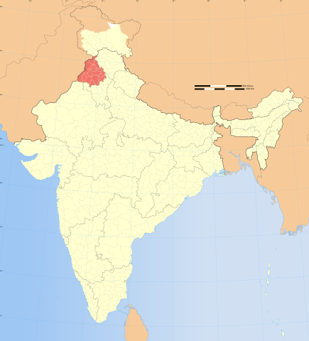
Punjab locator map |
|||||||||
| Description |
Locator map of the state of Kashmir, India with district boundaries. |
|||||||||
| Map legend |
 |
|||||||||
| ڕێکەوت | ||||||||||
| سەرچاوە |
بەرھەمی خۆم |
|||||||||
| ئافرێنەر |
|
|||||||||
| ڕێپێدان (بەکارھێنانەوەی ئەم پەڕگەیە) |
من، ھەڵگری مافی لەبەرگرتنەوەی ئەم بەرھەمە، لەژێر ئەم مۆڵەتنامەیەدا بڵاوی دەکەمەوە: ئەم پەڕگەیە لە ژێر مۆڵەتنامەی
Creative Commons Attribution-Share Alike 3.0 Unported دایە.
|
|||||||||
| Geotemporal data | ||||||||||
| Date depicted | نیوەی دووەمی سەدەی 20 و سەدەی 21 | |||||||||
| Spatial reference system | conic | |||||||||
| Bounding box |
|
|||||||||
| Georeferencing | If inappropriate please set warp_status = skip to hide. | |||||||||
| Archival data | ||||||||||
| تێبینییەکان | Part of WikiProject India Maps | |||||||||
| وەشانەکانی تر |
|
|||||||||


Notes
Depiction of India's borders
- The territorial boundaries of India are shown as per the actual ground situation in accordance with international practices followed by the United Nations ([1], [2]) and the National Geographic Society ([3], [4])
- This map is meant to be for illustrative purpose only and is not authenticated by official government sources. Please check the list of sources and references used to create the map for a measure of accuracy and verifiability.
- The usage of these maps in India, Pakistan and China are governed by different laws that restrict depictions of boundaries other than what is officially recognized by the state. Please check local laws and modify the map accordingly before use.
Explanation of disputed boundaries


- Boundary of Indian claim : The territory India claims is legally theirs, but the claim is disputed by China and Pakistan.
- Line of Control/Line of Conflict : The de facto administrative boundary recognised by the international community. This UN ceasefire line is considered as a temporary solution to an ongoing conflict since the departure of the British Raj.
Borders of disputed regions
The depicted extent of the former territory of the British Indian Empire, succeeded by Republic of India, may not be accepted by few countries as legal due to ongoing border disputes:
- The northern Himalayan region of the disputed territory Indian-administered Kashmir is claimed by India including (Pakistan-administered Kashmir) and the Chinese-occupied territory of (Ladakh plateau). Since 1972, it is divided between all three countries. See also Line of Control and Line of Actual Control.
- Siachen glacier (shown white) is an actively contested region between India and Pakistan. Since 1984, the region is under Indian control.
- The northeastern territory of Arunachal Pradesh is almost entirely claimed by China as part of its Tibetan territory.
- Minor areas of eastern Kashmir's Ladakh division, Himachal Pradesh and Uttarakhand on the Chinese frontier are claimed by China. These areas are under Indian control.
- A small area of Uttarakhand adjoining the Nepal border along the Sarda river is disputed between the two countries.
For a detailed map of all disputed regions in South Asia, see Image:India disputed areas map.svg
Internal borders
The borders of the state of Meghalaya, Assam and Arunachal Pradesh are shown as interpreted from the North-Eastern Areas (Reorganisation) Act, 1971, but has yet to be verified.
Territorial waters
The limit of the territorial waters of India extends to twelve nautical miles measured from the appropriate baseline. See this for more information.
مێژووی پەڕگە
کرتە بکە لەسەر یەکێک لە ڕێکەوت/کاتەکان بۆ بینینی پەڕگەکە بەو شێوەی لەو کاتەدا بووە.
| ڕێکەوت/کات | ھێما | ئەندازە | بەکارھێنەر | تێبینی | |
|---|---|---|---|---|---|
| هەنووکە | ٠٧:٠٩، ٢٩ی کانوونی یەکەمی ٢٠٠٨ | | ١٬٥٧٤ لە ١٬٧٣٨ (٨٣٦ کیلۆبایت) | Planemad | {{Information |Description= |Source= |Date= |Author= |Permission= |other_versions= }} |
| ١٧:٤٥، ٦ی ئابی ٢٠٠٦ |  | ١٬٦٣٩ لە ١٬٨٥٢ (٧٥١ کیلۆبایت) | Planemad | {{WikiProject_India_Maps |Title=Punjab locator map |Description=Locator map of the state of Punjab, India with district boundaries. |Source=. |Date=August 6 2006 |Author=w:user:Nichalpw:user:Planemad |Thumbdir=CHANGE }} |
بەکارھێنانی پەڕگە
ئەم پەڕەیە ئەم پەڕگەیە بەکار دەھێنێت:
بەکارھێنانی سەرانسەریی پەڕگە
ئەم ویکیانەی دیکەی خوارەوەش ئەم پەڕگە بەکاردێنن:
- بەکارھێنان لە ba.wikipedia.org
- بەکارھێنان لە be.wikipedia.org
- بەکارھێنان لە bg.wikipedia.org
- بەکارھێنان لە bh.wikipedia.org
- بەکارھێنان لە bn.wikipedia.org
- بەکارھێنان لە br.wikipedia.org
- بەکارھێنان لە da.wikipedia.org
- بەکارھێنان لە dty.wikipedia.org
- بەکارھێنان لە en.wikipedia.org
- Talk:Punjabi language
- Talk:Khalistan movement
- Talk:Sikhism
- Talk:Mitra
- Talk:Operation Blue Star
- Talk:Bathinda
- Talk:Amritsar
- Talk:Manmohan Singh
- Talk:Sukerchakia Misl
- Talk:Guru Ram Das
- Talk:Gatka
- Talk:Ranjit Singh
- Talk:Music of Punjab
- Talk:Malik
- Talk:Ika Omkara
- Talk:Jalandhar
- Hakim Pur, Doaba Region
- Qila Raipur
- Talk:Khaira, Ludhiana
- Talk:Damdami Taksal
- Talk:Bulleh Shah
- Rauni, Ludhiana
- Talk:Bhagat Singh
- Talk:Kirtan Sohila
- Talk:Guru Har Krishan
- Talk:Guru Tegh Bahadur
- Talk:Guru Har Rai
- Mandi Mullanpur
- Talk:Zafarnama (letter)
- Talk:Iftikhar Ali Khan Pataudi
- Talk:Jagjit Singh Aurora
- Talk:Babbar Khalsa
- Harnam Singh Wala
- Talk:Waheguru
- Sobraon
- Talk:Bajwa
- Talk:Khemkaran
- Punjab Plain
- Talk:Gurdwara
- Talk:List of Sikhs
- Talk:Inderjit Singh Bindra Stadium
- Talk:Guru Gobind Singh
بینینی بەکارھێنانی گشتی زیاتری ئەم پەڕگەیە.