پەڕگە:Grytviken-Location.jpg

قەبارەی ئەم پێشبینینە: ٨٠٠ لە ٥٦٠ پیکسەڵ. ڕێزەلووشنەکانی تر: ٣٢٠ لە ٢٢٤ پیکسەڵ | ٦٤٠ لە ٤٤٨ پیکسەڵ | ١٬٠٢٤ لە ٧١٧ پیکسەڵ | ١٬٢٨٠ لە ٨٩٦ پیکسەڵ | ٢٬١٦٥ لە ١٬٥١٦ پیکسەڵ.
پەڕگەی سەرەکی (٢٬١٦٥ × ١٬٥١٦ پیکسڵ، قەبارەی پەڕگە: ١٫٤٨ مێگابایت، جۆری ئێم ئای ئێم ئی: image/jpeg)
کورتە
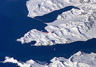
English: Satellite image of central South Georgia Island - in the Antarctic region.
- View of Cumberland Bay area, South Georgia Island: Thatcher Peninsula with King Edward Cove and Grytviken (red).
- Credits
- Fragment made by Apcbg.
- Image
- Science and Analysis Laboratory, NASA-Johnson Space Center. 25 Mar. 2005. "Astronaut Photography of Earth - Display Record."[1]
Source URL
مۆڵەتنامە
| This file is in the public domain in the United States because it was solely created by NASA. NASA copyright policy states that "NASA material is not protected by copyright unless noted". (See Template:PD-USGov, NASA copyright policy page or JPL Image Use Policy.) | ||
 |
Warnings:
|
مێژووی پەڕگە
کرتە بکە لەسەر یەکێک لە ڕێکەوت/کاتەکان بۆ بینینی پەڕگەکە بەو شێوەی لەو کاتەدا بووە.
| ڕێکەوت/کات | ھێما | ئەندازە | بەکارھێنەر | تێبینی | |
|---|---|---|---|---|---|
| هەنووکە | ٠٩:١٩، ١ی تشرینی یەکەمی ٢٠٠٧ | | ٢٬١٦٥ لە ١٬٥١٦ (١٫٤٨ مێگابایت) | Apcbg | == Summary == Satellite image of Cumberland Bay area, South Georgia Island: Thatcher Peninsula with King Edward Cove and Grytviken. Fragment made by Apcbg. Image Science and Analysis Laboratory, NASA-Johnson Space Center. 25 Mar. 2005. "Astronaut Photog |
| ١٠:٣٢، ٢٧ی ئایاری ٢٠٠٦ |  | ٢٬٠٩٣ لە ١٬٤٩٥ (١٫١٨ مێگابایت) | Apcbg | Satellite image of Cumberland Bay area, South Georgia Island: Thatcher Peninsula with King Edward Cove and Grytviken. Fragment made by Apcbg. Image Science and Analysis Laboratory, NASA-Johnson Space Center. 25 Mar. 2005. "Astronaut Photography of Earth |
بەکارھێنانی پەڕگە
ئەم پەڕەیە ئەم پەڕگەیە بەکار دەھێنێت:
بەکارھێنانی سەرانسەریی پەڕگە
ئەم ویکیانەی دیکەی خوارەوەش ئەم پەڕگە بەکاردێنن:
- بەکارھێنان لە ang.wikipedia.org
- بەکارھێنان لە ar.wikipedia.org
- بەکارھێنان لە ast.wikipedia.org
- بەکارھێنان لە az.wikipedia.org
- بەکارھێنان لە bg.wikipedia.org
- بەکارھێنان لە ca.wikipedia.org
- بەکارھێنان لە en.wikipedia.org
- بەکارھێنان لە es.wikipedia.org
- بەکارھێنان لە fa.wikipedia.org
- بەکارھێنان لە hr.wikipedia.org
- بەکارھێنان لە id.wikipedia.org
- بەکارھێنان لە it.wikipedia.org
- بەکارھێنان لە lad.wikipedia.org
- بەکارھێنان لە ms.wikipedia.org
- بەکارھێنان لە nl.wikipedia.org
- بەکارھێنان لە nn.wikipedia.org
- بەکارھێنان لە no.wikipedia.org
- بەکارھێنان لە ru.wikipedia.org
- بەکارھێنان لە sh.wikipedia.org
- بەکارھێنان لە sk.wikipedia.org
- بەکارھێنان لە sr.wikipedia.org
- بەکارھێنان لە sv.wikipedia.org
- بەکارھێنان لە ta.wikipedia.org
- بەکارھێنان لە th.wikipedia.org
- بەکارھێنان لە uk.wikipedia.org
- بەکارھێنان لە zh.wikipedia.org