پەڕگە:Germanic tribes (750BC-1AD).png
رەزۆلوشنی سەرتر لەمە لە بەردەست دا نیە.
Germanic_tribes_(750BC-1AD).png (٥٣٧ × ٣٧٦ پیکسڵ، قەبارەی پەڕگە: ١٠ کیلۆبایت، جۆری ئێم ئای ئێم ئی: image/png)
.png)
کورتە

|
File:Germanic tribes settlements 750BC-1AD.svg is a vector version of this file. It should be used in place of this PNG file when not inferior.
File:Germanic tribes (750BC-1AD).png → File:Germanic tribes settlements 750BC-1AD.svg
For more information, see Help:SVG. |
 |
| وەسف |
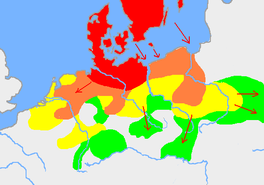
English: Based on p. 108 in the Penguin Atlas of World History, volume 1, from the Beginning to the Eve of the French Revolution. 1988. ISBN 0-14-051054-0. Note that the map assumes that the Nordwestblock was Germanized before 500 BC. This is uncertain; alternative proposals hold that the area near the mouths of the Rhine came under a Germanic superstate only in the 1st century BC.
The map is drawn on en:User:Dbachmann's blank map: en:Image:Europe plain rivers.png Settlements before 750 bc
New settlements by 500 bc
New settlements by 250 bc
New settlements by ad 1
Archived copy of a version of the original map. |
| ڕێکەوت | ٢١ی کانوونی دووەمی ٢٠٠٧ (original upload date) |
| سەرچاوە | Transferred from en.wikipedia to Commons. |
| بەرھەمھێنەر | Berig at ئینگلیزی ویکیپیدیا |
see also Image:Pre Migration Age Germanic.png
مۆڵەتنامە
I, Berig، ھەڵگری مافی لەبەرگرتنەوەی ئەم بەرھەمە، لەژێر ئەم مۆڵەتنامەیانەدا بڵاوی دەکاتەوە:

|
ڕێگەدراوە بە لەبەرگرتنەوە، دابەشکردن ھەروەھا/یان سازاندنی ئەم بەڵگەنامەیە لەژێر مەرجی مۆڵەتی GNU بۆ بەڵگەنامەی ئازاد، وەشانی ١.٢ یان ھەر وەشانێکی تری دواتر کە بڵاوکراوەتەوە لەلایەن دامەزراوەی بەرنامەی ئازاد، بەبێ ھیچ بەشێکی جیاواز، بەبێ نووسین لەسەر بەرگی پێشەوە و دواوەی. وێنەیەک لەمۆڵەتەکە لە بەشێکدا ھەیە کە ناوی مۆڵەتی GNU بۆ بەڵگەنامەی ئازادە. |
| ئەم پەڕگەیە لە ژێر مۆڵەتنامەی | ||
| دانەپاڵ: I, Berig | ||
| ||
| This licensing tag was added to this file as part of the GFDL licensing update. |
This file is licensed under the Creative Commons Attribution 2.5 Generic license.
دانەپاڵ: I, Berig
- تۆ ئازادی:
- بۆ بڵاکردنەوە – بۆ کۆپی کردن، دابەشکردن و دەستبەدەست ناردنی
- بۆ تێکەڵکردنەوە – بۆ سازاندنی کارەکە
- بەم مەرجانەی خوارەوە:
- دانەپاڵ – پێویستە باوەڕی گونجاو بدەیت، بەستەرێک بۆ مۆڵەتەکە دابین بکەیت و ئاماژە بەوە بکەیت کە ئایا گۆڕانکاری کراوە یان نا. دەتوانیت بە هەر شێوەیەکی گونجاو ئەوە بکەیت، بەڵام بە شێوەیەک نا کە وا دەربکەوێت کە مۆڵەتدەر پشتگیری تۆ یان بەکارهێنانەکەت بکات.
دەتوانی مۆڵەتنامەی دڵخوازت ھەڵبژێریت.
Original upload log
The original description page was here. All following user names refer to en.wikipedia.
- 2007-01-21 10:52 Berig 537×376×8 (18448 bytes) Based on p. 108 in the Penguin Atlas of World History, volume 1, from the Beginning to the Eve of the French Revolution. 1988. The map is drawn on [[User:Dbachmann]]'s blank map: [[:Image:Europe plain rivers.png]]
مێژووی پەڕگە
کرتە بکە لەسەر یەکێک لە ڕێکەوت/کاتەکان بۆ بینینی پەڕگەکە بەو شێوەی لەو کاتەدا بووە.
| ڕێکەوت/کات | ھێما | ئەندازە | بەکارھێنەر | تێبینی | |
|---|---|---|---|---|---|
| هەنووکە | ٠٠:٣٤، ١٧ی شوباتی ٢٠٠٩ | | ٥٣٧ لە ٣٧٦ (١٠ کیلۆبایت) | Disposable.Heroes | pngcrush |
| ١٧:١٧، ١١ی ئازاری ٢٠٠٧ |  | ٥٣٧ لە ٣٧٦ (١٨ کیلۆبایت) | R9tgokunks | {{Information |Description=Based on p. 108 in the Penguin Atlas of World History, volume 1, from the Beginning to the Eve of the French Revolution. 1988. ISBN 0-14-051054-0 The map is drawn on en:User:Dbachmann's blank map: [[:en::Image:Europe plain | |
| ٢٠:١٧، ١١ی شوباتی ٢٠٠٧ |  | ٥٣٧ لە ٣٧٦ (١٨ کیلۆبایت) | Electionworld | {{Information |Description=Based on p. 108 in the Penguin Atlas of World History, volume 1, from the Beginning to the Eve of the French Revolution. 1988. ISBN 0-14-051054-0 The map is drawn on en:User:Dbachmann's blank map: [[:en::Image:Europe plain |
بەکارھێنانی پەڕگە
ئەم پەڕەیە ئەم پەڕگەیە بەکار دەھێنێت:
بەکارھێنانی سەرانسەریی پەڕگە
ئەم ویکیانەی دیکەی خوارەوەش ئەم پەڕگە بەکاردێنن:
- بەکارھێنان لە af.wikipedia.org
- بەکارھێنان لە ar.wikipedia.org
- بەکارھێنان لە ast.wikipedia.org
- بەکارھێنان لە av.wikipedia.org
- بەکارھێنان لە azb.wikipedia.org
- بەکارھێنان لە bg.wikipedia.org
- بەکارھێنان لە bn.wikipedia.org
- بەکارھێنان لە bs.wikipedia.org
- بەکارھێنان لە ca.wikipedia.org
- بەکارھێنان لە cv.wikipedia.org
- بەکارھێنان لە de.wikipedia.org
- بەکارھێنان لە el.wikipedia.org
- بەکارھێنان لە en.wikipedia.org
- Bastarnae
- Celts
- Germanic languages
- Germanic peoples
- History of Germany
- History of the Netherlands
- Lombards
- AD 1
- 250 BC
- Marchian
- Eastphalian language
- Proto-Germanic language
- Ruhrdeutsch
- East Germanic languages
- Talk:Germania
- Benrath line
- Lexin
- Vadstena bracteate
- Svealand dialects
- Leew Eilun Feer
- South Franconian German
- Highest Alemannic German
- Moselle Franconian language
- Stellingwarfs dialect
- Veluws dialect
بینینی بەکارھێنانی گشتی زیاتری ئەم پەڕگەیە.
.png)
.png)