پەڕگە:FrobisherBayOMC.png
رەزۆلوشنی سەرتر لەمە لە بەردەست دا نیە.
FrobisherBayOMC.png (٤٩٦ × ٤٩٦ پیکسڵ، قەبارەی پەڕگە: ١٧ کیلۆبایت، جۆری ئێم ئای ئێم ئی: image/png)
کورتە
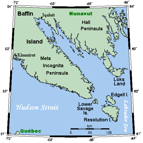
| وەسف |
English: A map showing Frobisher Bay and nearby areas. This map's source is here, with the uploader's modifications, and the GMT homepage says that the tools are released under the GNU General Public License. |
| ڕێکەوت | ١٢ی تەممووزی ٢٠٠٧ (original upload date) |
| سەرچاوە | Transferred from en.wikipedia to Commons. |
| بەرھەمھێنەر | Kelisi at ئینگلیزی ویکیپیدیا |
مۆڵەتنامە
Kelisi from en.wikipedia.org، ھەڵگری مافی لەبەرگرتنەوەی ئەم بەرھەمە، لەژێر ئەم مۆڵەتنامەیەدا بڵاوی دەکاتەوە:
| ئەم پەڕگەیە لە ژێر مۆڵەتنامەی
Creative Commons Attribution-Share Alike 3.0 Unported دایە. Subject to disclaimers. |
||
| دانەپاڵ: Kelisi from en.wikipedia.org | ||
| ||
| This licensing tag was added to this file as part of the GFDL licensing update. |

|
ڕێگەدراوە بە لەبەرگرتنەوە، دابەشکردن ھەروەھا/یان سازاندنی ئەم بەڵگەنامەیە لەژێر مەرجی مۆڵەتی GNU بۆ بەڵگەنامەی ئازاد، وەشانی ١.٢ یان ھەر وەشانێکی تری دواتر کە بڵاوکراوەتەوە لەلایەن دامەزراوەی بەرنامەی ئازاد، بەبێ ھیچ بەشێکی جیاواز، بەبێ نووسین لەسەر بەرگی پێشەوە و دواوەی. وێنەیەک لەمۆڵەتەکە لە بەشێکدا ھەیە کە ناوی مۆڵەتی GNU بۆ بەڵگەنامەی ئازادە. Subject to disclaimers. |
Original upload log
The original description page was here. All following user names refer to en.wikipedia.
- 2007-07-12 19:16 Kelisi 496×496×8 (17371 bytes)
- 2007-07-12 16:43 Kelisi 493×496×8 (16903 bytes) == Summary == A map showing Frobisher Bay and nearby areas. This map's source is [http://www.aquarius.ifm-geomar.de/ here], with the uploader's modifications, and the [http://gmt.soest.hawaii.edu/ GMT homepage] says that the tools are released under the G
مێژووی پەڕگە
کرتە بکە لەسەر یەکێک لە ڕێکەوت/کاتەکان بۆ بینینی پەڕگەکە بەو شێوەی لەو کاتەدا بووە.
| ڕێکەوت/کات | ھێما | ئەندازە | بەکارھێنەر | تێبینی | |
|---|---|---|---|---|---|
| هەنووکە | ١٧:٥٨، ١٠ی تەممووزی ٢٠٠٨ | | ٤٩٦ لە ٤٩٦ (١٧ کیلۆبایت) | Urdangaray | {{Information |Description={{en|A map showing Frobisher Bay and nearby areas. This map's source is [http://www.aquarius.ifm-geomar.de/ here], with the uploader's modifications, and the [http://gmt.soest.hawaii.edu/ GMT homepage] says that the tools are re |
بەکارھێنانی پەڕگە
ئەم پەڕەیە ئەم پەڕگەیە بەکار دەھێنێت:
بەکارھێنانی سەرانسەریی پەڕگە
ئەم ویکیانەی دیکەی خوارەوەش ئەم پەڕگە بەکاردێنن:
- بەکارھێنان لە ca.wikipedia.org
- بەکارھێنان لە da.wikipedia.org
- بەکارھێنان لە de.wikipedia.org
- بەکارھێنان لە en.wikipedia.org
- بەکارھێنان لە es.wikipedia.org
- بەکارھێنان لە fa.wikipedia.org
- بەکارھێنان لە hu.wikipedia.org
- بەکارھێنان لە it.wikipedia.org
- بەکارھێنان لە ja.wikipedia.org
- بەکارھێنان لە lfn.wikipedia.org
- بەکارھێنان لە ml.wikipedia.org
- بەکارھێنان لە nn.wikipedia.org
- بەکارھێنان لە no.wikipedia.org