پەڕگە:Four corners.jpg
قەبارەی ئەم پێشبینینە: ٤٦٥ لە ٥٩٩ پیکسەڵ. ڕێزەلووشنەکانی تر: ١٨٦ لە ٢٤٠ پیکسەڵ | ٣٧٢ لە ٤٨٠ پیکسەڵ | ٥٩٦ لە ٧٦٨ پیکسەڵ | ٧٩٤ لە ١٬٠٢٤ پیکسەڵ | ١٬٥٨٩ لە ٢٬٠٤٨ پیکسەڵ | ٤٬٥٠٠ لە ٥٬٨٠٠ پیکسەڵ.
پەڕگەی سەرەکی (٤٬٥٠٠ × ٥٬٨٠٠ پیکسڵ، قەبارەی پەڕگە: ٤٫٣٣ مێگابایت، جۆری ئێم ئای ئێم ئی: image/jpeg)
کورتە
| وەسف |
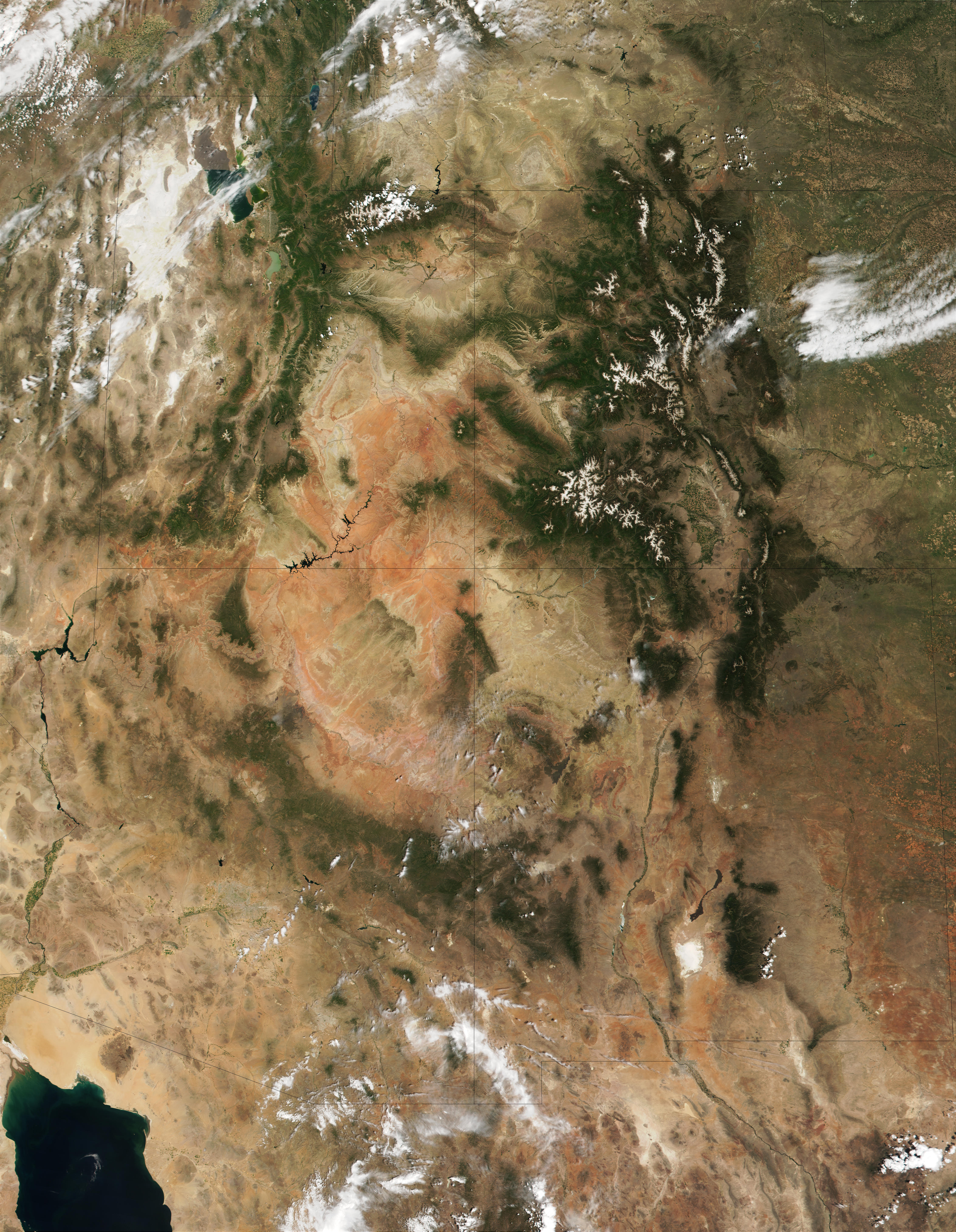
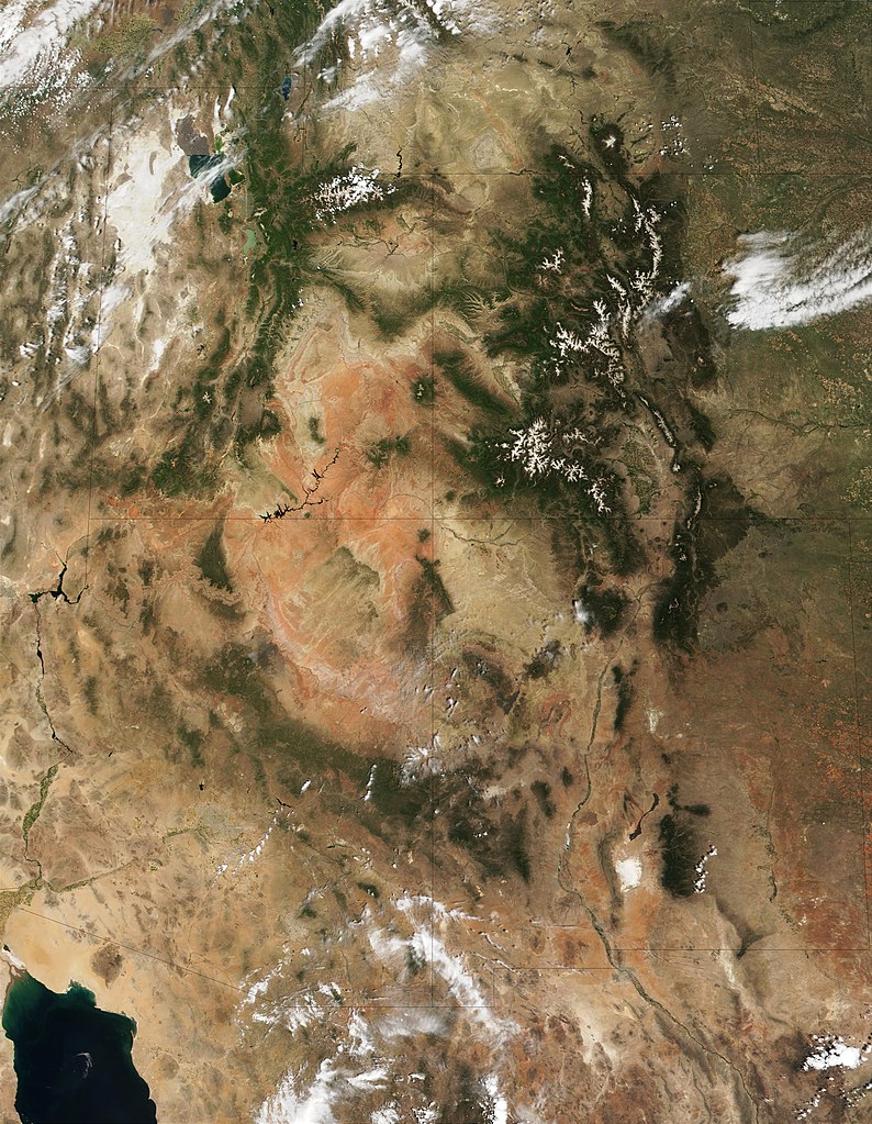
English: This MODIS true-color image is centered on the Four Corners region in the Southwest United States. Recognizable features include the forest-covered Rocky Mountains, which still have snow-covered peaks, running through Colorado and into New Mexico. To the west of Colorado is Utah, where the Great Salt Lake can be seen at the upper left. The Colorado Plateau, with its salmon-colored rocks, extends south from Utah into Arizona. The Grand Canyon of the Colorado River cuts westward through the mountains in northern Arizona. |
| ڕێکەوت | |
| سەرچاوە | http://visibleearth.nasa.gov/view_rec.php?id=1980 |
| بەرھەمھێنەر | Jacques Descloitres, MODIS Land Rapid Response Team (NASA) |
مۆڵەتنامە
| This file is in the public domain in the United States because it was solely created by NASA. NASA copyright policy states that "NASA material is not protected by copyright unless noted". (See Template:PD-USGov, NASA copyright policy page or JPL Image Use Policy.) | ||
 |
Warnings:
|
مێژووی پەڕگە
کرتە بکە لەسەر یەکێک لە ڕێکەوت/کاتەکان بۆ بینینی پەڕگەکە بەو شێوەی لەو کاتەدا بووە.
| ڕێکەوت/کات | ھێما | ئەندازە | بەکارھێنەر | تێبینی | |
|---|---|---|---|---|---|
| هەنووکە | ١١:٥٣، ٢٠ی کانوونی یەکەمی ٢٠١٠ | | ٤٬٥٠٠ لە ٥٬٨٠٠ (٤٫٣٣ مێگابایت) | Orionist | high res from original source |
| ١٣:٣٢، ٢٣ی شوباتی ٢٠٠٥ |  | ٣٩٦ لە ٥١١ (١٨٧ کیلۆبایت) | Complex01 |
بەکارھێنانی پەڕگە
ئەم پەڕەیە ئەم پەڕگەیە بەکار دەھێنێت:
بەکارھێنانی سەرانسەریی پەڕگە
ئەم ویکیانەی دیکەی خوارەوەش ئەم پەڕگە بەکاردێنن:
- بەکارھێنان لە ar.wikipedia.org
- بەکارھێنان لە az.wikipedia.org
- بەکارھێنان لە bg.wikipedia.org
- بەکارھێنان لە bn.wikipedia.org
- بەکارھێنان لە bs.wikipedia.org
- بەکارھێنان لە en.wikipedia.org
- بەکارھێنان لە es.wikipedia.org
- بەکارھێنان لە et.wikipedia.org
- بەکارھێنان لە fa.wikipedia.org
- بەکارھێنان لە fi.wikipedia.org
- بەکارھێنان لە he.wikipedia.org
- بەکارھێنان لە hu.wikipedia.org
- بەکارھێنان لە it.wikipedia.org
- بەکارھێنان لە ja.wikipedia.org
- بەکارھێنان لە ka.wikipedia.org
- بەکارھێنان لە kk.wikipedia.org
- بەکارھێنان لە kn.wikipedia.org
- بەکارھێنان لە ko.wikipedia.org
- بەکارھێنان لە lfn.wikipedia.org
- بەکارھێنان لە lt.wikipedia.org
- بەکارھێنان لە mk.wikipedia.org
- بەکارھێنان لە ml.wikipedia.org
- بەکارھێنان لە nl.wikipedia.org
- بەکارھێنان لە pa.wikipedia.org
- بەکارھێنان لە pl.wikipedia.org
- بەکارھێنان لە pnb.wikipedia.org
- بەکارھێنان لە pt.wikipedia.org
- بەکارھێنان لە ru.wikipedia.org
- بەکارھێنان لە si.wikipedia.org
- بەکارھێنان لە sq.wikipedia.org
- بەکارھێنان لە ta.wikipedia.org
- بەکارھێنان لە vi.wikipedia.org
- بەکارھێنان لە zh.wikipedia.org