پەڕگە:Falkland Islands topographic map-en.svg
پەڕگەی سەرەکی(پەڕگەی SVG، بە ناو ٢٬٥٥٠ × ١٬٩٩٠ پیکسەڵ، قەبارەی پەڕگە: ١٫٩٧ مێگابایت)

ئەم پەڕگە لە Wikimedia Commonsەوەیە و لەوانەیە لە پڕۆژەکانی دیکەش بەکار ھاتبێت. پێناسەکەی لەسەر پەڕەی وەسفی پەڕگەکە لە خوارەوە نیشان دراوە.

 
  This SVG map uses required raster graphics to show delicate structures.
وێنە of the year
وێنە of the year
Featured وێنە

ویکیمیدیا کۆمنزویکیپیدیا

ئەم وێنەیە پێ بەخشرا لە وێنەی گشتی جیھان ٢٠٠٧.
ئەم وێنەیە ھەڵبژێردراو بوو لە ویکیمیدیا کۆمنز (Featured pictures) و ھەڵبژێردراوە بۆ ئەوەی ببێت بە باشترین وێنەکان.

 ئەم وێنەیە ھەڵبژێردراو بوو لە ویکیپیدیا ئینگلیزی (Featured pictures) و ھەڵبژێردراوە بۆ ئەوەی ببێت بە باشترین وێنەکان.

ئەگەر وێنەیەکی ھاوشێوەت ھەبوو نموونە دەتواندرێت باربکرێت لەژێر مۆڵەتنامەی Commons:Licensing مۆڵەتنامەی گونجاو، ھەستە بە باری کە، و مافی بپارێزە، و بیپاڵێوە.


Pour agrandir l'image

Detailed map of large dimension. For a better viewing, click on the link of the image above.
Carte détaillée de grande dimension. Pour une visualisation optimale, cliquer sur le lien de l'image ci-dessus.

کورتە

Description
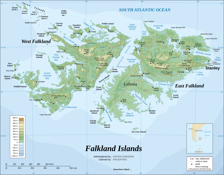
English: The Falkland Islands are an archipelago in the South Atlantic Ocean, located 300 miles off the coast of Argentina. They consist of two main islands, East Falkland and West Falkland, together with about 700 smaller islands. Stanley, on East Falkland, is the capital and largest city. The islands are a self-governing Overseas Territory of the United Kingdom.
Français : Carte topographique en anglais des Îles Malouines. Les Malouines forment un archipel dans l'Océan Atlantique Sud à 480 km des côtes argentines. Il est composé de deux îles principales, East Falkland et West Falkland, et de 700 autres îles et îlots. Stanley, sur East Falkland, est la capitale et la plus grande agglomération de l'archipel. Les Malouines sont un territoire autonome du Royaume-Uni.
Nederlands: Topografische kaart van de Falklandeilanden, een Brits overzees gebiedsdeel in de Zuidelijke Atlantische Oceaan. De archipel bestaat uit twee hoofdeilanden en ongeveer 700 kleinere op ongeveer 300 kilometer uit de kust van Argentinië. Stanley op het eiland 'East Falkland' is de hoofdstad en tergelijkertijd de meest bevolkte gemeente van het eilandengroep.De eilanden zijn een 'self-governing Overseas Territory' van het Verenigd Koninkrijk van Groot-Brittannië en Noord-Ierland.
Português: Mapa topográfico (em inglês) das Ilhas Malvinas, um arquipélago no sul do Oceano Atlântico, a 300 milhas da costa da Argentina. Consiste de duas ilhas, Soledad a leste e Gran Malvina, a oeste, junto com cerca de 700 outras ilhotas. A capital (e maior cidade) é Stanley. As Malvinas são um território autónomo do Reino Unido.
SVG genesis
InfoField
 
The SVG code is valid.
 
This map was created with Inkscape.
{| cellspacing="8" cellpadding="0" style="clear:both; width:100%; margin:0.5em auto; border:2px solid #88A; background-color:#F7F8FF;" lang="en" dir="ltr"

|align="center"|Translate this file |width="100%"| This SVG file contains embedded text that can be translated into your language, using any capable SVG editor, text editor or the SVG Translate tool. For more information see: About translating SVG files.

|}
ڕێکەوت November 2007 using elements from the original version of April 2007
سەرچاوە Own work ;
Topographic map : NASA Shuttle Radar Topography Mission (SRTM3 v.2) (public domain) edited with dlgv32 Pro/Global Mapper and vectorized with Inkscape ; UTM projection ; WGS84 datum ; shaded relief (composite image of N-W, W and N lightning positions) ;
Approximate scale of topographic data and shore / lakes limits : 1:705,000 ; of the bathymetry : 1:3.720.000
Bathymetry : USGov public domain data provided by the Demis add-on for World Wind (see the approval e-mail) ;
Other references used for additional data :
* UK government map ;
* NASA World Wind ;
* CIA map available on the site of the University of Texas at Austin ;
* Microsoft Encarta atlas (1999 edition).
Note : The shaded relief is a raster image embedded in the SVG file which increases its size. If you want a lighter map for other purposes, delete the shaded relief image in your file.
ئافرێنەر
Eric Gaba (Sting - fr:Sting)
ڕێپێدان
(بەکارھێنانەوەی ئەم پەڕگەیە)
Attribution and Share-Alike required
Georeferencing Georeference the map in Wikimaps Warper If inappropriate please set warp_status = skip to hide.
وەشانەکانی تر

Derivative works of this file:

[دەستکاری]


مۆڵەتنامە

من، ھەڵگری مافی لەبەرگرتنەوەی ئەم بەرھەمە، لەژێر ئەم مۆڵەتنامەیانەدا بڵاوی دەکەمەوە:
GNU head ڕێگەدراوە بە لەبەرگرتنەوە، دابەشکردن ھەروەھا/یان سازاندنی ئەم بەڵگەنامەیە لەژێر مەرجی مۆڵەتی GNU بۆ بەڵگەنامەی ئازاد، وەشانی ١.٢ یان ھەر وەشانێکی تری دواتر کە بڵاوکراوەتەوە لەلایەن دامەزراوەی بەرنامەی ئازاد، بەبێ ھیچ بەشێکی جیاواز، بەبێ نووسین لەسەر بەرگی پێشەوە و دواوەی. وێنەیەک لەمۆڵەتەکە لە بەشێکدا ھەیە کە ناوی مۆڵەتی GNU بۆ بەڵگەنامەی ئازادە.
w:en:Creative Commons
دانەپاڵ بڵاوکردنەوەی گونجاو
ئەم پەڕگەیە لە ژێر مۆڵەتنامەی

Creative Commons Attribution-Share Alike 3.0 Unported دایە.

تۆ ئازادی:
  • بۆ بڵاکردنەوە – بۆ کۆپی کردن، دابەشکردن و دەستبەدەست ناردنی
  • بۆ تێکەڵکردنەوە – بۆ سازاندنی کارەکە
بەم مەرجانەی خوارەوە:
  • دانەپاڵ – پێویستە باوەڕی گونجاو بدەیت، بەستەرێک بۆ مۆڵەتەکە دابین بکەیت و ئاماژە بەوە بکەیت کە ئایا گۆڕانکاری کراوە یان نا. دەتوانیت بە هەر شێوەیەکی گونجاو ئەوە بکەیت، بەڵام بە شێوەیەک نا کە وا دەربکەوێت کە مۆڵەتدەر پشتگیری تۆ یان بەکارهێنانەکەت بکات.
  • بڵاوکردنەوەی گونجاو – ئەگەر لەسەر بنەمای ئەم کارە تێکەڵ، گۆڕان، یان ساز بکەی، پێویستە بەشدارییەکانت بە هەمان مۆڵەت یان هاوشێوەی مۆڵەتی ئەسڵی دابەش بکەی.
This licensing tag was added to this file as part of the GFDL licensing update.
w:en:Creative Commons
دانەپاڵ بڵاوکردنەوەی گونجاو
This file is licensed under the Creative Commons Attribution-Share Alike 2.5 Generic, 2.0 Generic and 1.0 Generic license.
تۆ ئازادی:
  • بۆ بڵاکردنەوە – بۆ کۆپی کردن، دابەشکردن و دەستبەدەست ناردنی
  • بۆ تێکەڵکردنەوە – بۆ سازاندنی کارەکە
بەم مەرجانەی خوارەوە:
  • دانەپاڵ – پێویستە باوەڕی گونجاو بدەیت، بەستەرێک بۆ مۆڵەتەکە دابین بکەیت و ئاماژە بەوە بکەیت کە ئایا گۆڕانکاری کراوە یان نا. دەتوانیت بە هەر شێوەیەکی گونجاو ئەوە بکەیت، بەڵام بە شێوەیەک نا کە وا دەربکەوێت کە مۆڵەتدەر پشتگیری تۆ یان بەکارهێنانەکەت بکات.
  • بڵاوکردنەوەی گونجاو – ئەگەر لەسەر بنەمای ئەم کارە تێکەڵ، گۆڕان، یان ساز بکەی، پێویستە بەشدارییەکانت بە هەمان مۆڵەت یان هاوشێوەی مۆڵەتی ئەسڵی دابەش بکەی.
دەتوانی مۆڵەتنامەی دڵخوازت ھەڵبژێریت.

لێدوانەکان

Add a one-line explanation of what this file represents

بەندەکانی لەم پەڕگەیەدا دەردەکەون

depicts ئینگلیزی

media type ئینگلیزی

image/svg+xml

مێژووی پەڕگە

کرتە بکە لەسەر یەکێک لە ڕێکەوت/کاتەکان بۆ بینینی پەڕگەکە بەو شێوەی لەو کاتەدا بووە.

(نوێترین | کۆنترین) (١٠ی نوێتر | ) (١٠ | ٢٠ | ٥٠ | ١٠٠ | ٢٥٠ | ٥٠٠) ببینە
ڕێکەوت/کاتھێمائەندازەبەکارھێنەرتێبینی
هەنووکە‏٠٢:٥١، ٢٣ی ئابی ٢٠٢١ھێما بۆ وەشانی  ‏٠٢:٥١، ٢٣ی ئابی ٢٠٢١٢٬٥٥٠ لە ١٬٩٩٠ (١٫٩٧ مێگابایت)Praça de MaioFile uploaded using svgtranslate tool (https://svgtranslate.toolforge.org/). Added translation for tr.
‏٠٢:٥٠، ٢٣ی ئابی ٢٠٢١ھێما بۆ وەشانی  ‏٠٢:٥٠، ٢٣ی ئابی ٢٠٢١٢٬٥٥٠ لە ١٬٩٩٠ (١٫٩٧ مێگابایت)Praça de MaioFile uploaded using svgtranslate tool (https://svgtranslate.toolforge.org/). Added translation for tr.
‏١١:٥٤، ٦ی نیسانی ٢٠١٧ھێما بۆ وەشانی  ‏١١:٥٤، ٦ی نیسانی ٢٠١٧٢٬٥٥٠ لە ١٬٩٩٠ (١٫٩١ مێگابایت)RaviC+ New Haven Ferry
‏١٨:٣٨، ١٩ی کانوونی یەکەمی ٢٠٠٨ھێما بۆ وەشانی  ‏١٨:٣٨، ١٩ی کانوونی یەکەمی ٢٠٠٨٢٬٥٥٠ لە ١٬٩٩٠ (١٫٩٣ مێگابایت)StingReverted to version as of 03:38, 14 November 2007: please upload the translated version under a specific name
‏١٨:٢٦، ١٩ی کانوونی یەکەمی ٢٠٠٨ھێما بۆ وەشانی  ‏١٨:٢٦، ١٩ی کانوونی یەکەمی ٢٠٠٨٢٬٥٥٠ لە ١٬٩٩٠ (١٫٩٣ مێگابایت)Vitekthis is just croatian translation
‏٠٣:٣٨، ١٤ی تشرینی دووەمی ٢٠٠٧ھێما بۆ وەشانی  ‏٠٣:٣٨، ١٤ی تشرینی دووەمی ٢٠٠٧٢٬٥٥٠ لە ١٬٩٩٠ (١٫٩٣ مێگابایت)StingNew version more accurate and with shaded relief
‏٠١:١٨، ١٦ی حوزەیرانی ٢٠٠٧ھێما بۆ وەشانی  ‏٠١:١٨، ١٦ی حوزەیرانی ٢٠٠٧٢٬٥٥٠ لە ١٬٩٩٠ (١٫٠٣ مێگابایت)StingReverted to earlier revision
‏٠١:٠٣، ١٦ی حوزەیرانی ٢٠٠٧ھێما بۆ وەشانی  ‏٠١:٠٣، ١٦ی حوزەیرانی ٢٠٠٧٢٬٥٥٠ لە ١٬٩٩٠ (٢٫١٤ مێگابایت)StingTrying to fix the bug on WP-en #8
‏٠٠:٤٠، ١٦ی حوزەیرانی ٢٠٠٧ھێما بۆ وەشانی  ‏٠٠:٤٠، ١٦ی حوزەیرانی ٢٠٠٧٢٬٥٥٠ لە ١٬٩٩٠ (٢٫٠١ مێگابایت)StingTrying to fix the bug on WP-en #7 (really boring...)
‏٠٠:٢٩، ١٦ی حوزەیرانی ٢٠٠٧ھێما بۆ وەشانی  ‏٠٠:٢٩، ١٦ی حوزەیرانی ٢٠٠٧٢٬٥٥٠ لە ١٬٩٩٠ (٢٫٠٨ مێگابایت)StingTrying to fix the bug on WP-en #6 (OK, the problem comes from the shaded relief raster image)
(نوێترین | کۆنترین) (١٠ی نوێتر | ) (١٠ | ٢٠ | ٥٠ | ١٠٠ | ٢٥٠ | ٥٠٠) ببینە

ئەم پەڕەیە ئەم پەڕگەیە بەکار دەھێنێت:

بەکارھێنانی سەرانسەریی پەڕگە

ئەم ویکیانەی دیکەی خوارەوەش ئەم پەڕگە بەکاردێنن:

بینینی بەکارھێنانی گشتی زیاتری ئەم پەڕگەیە.

دراوی مێتا