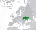
پەڕگە:Europe-Ukraine (disputed territory).svg

Size of this PNG preview of this SVG file: ٧١٣ لە ٦٠٠ پیکسەڵ. ڕێزەلووشنەکانی تر: ٢٨٥ لە ٢٤٠ پیکسەڵ | ٥٧١ لە ٤٨٠ پیکسەڵ | ٩١٣ لە ٧٦٨ پیکسەڵ | ١٬٢١٨ لە ١٬٠٢٤ پیکسەڵ | ٢٬٤٣٥ لە ٢٬٠٤٨ پیکسەڵ | ٢٬٠٤٥ لە ١٬٧٢٠ پیکسەڵ.
پەڕگەی سەرەکی (پەڕگەی SVG، بە ناو ٢٬٠٤٥ × ١٬٧٢٠ پیکسەڵ، قەبارەی پەڕگە: ٧٫٠١ مێگابایت)
مێژووی پەڕگە
کرتە بکە لەسەر یەکێک لە ڕێکەوت/کاتەکان بۆ بینینی پەڕگەکە بەو شێوەی لەو کاتەدا بووە.
| ڕێکەوت/کات | ھێما | ئەندازە | بەکارھێنەر | تێبینی | |
|---|---|---|---|---|---|
| هەنووکە | ١٩:٤٣، ٧ی تەممووزی ٢٠٢٣ |  | ٢٬٠٤٥ لە ١٬٧٢٠ (٧٫٠١ مێگابایت) | Krestenti | update |
| ٠١:٢١، ١٠ی ئازاری ٢٠١٧ |  | ٢٬٠٤٥ لە ١٬٧٢٠ (٧٫٣٨ مێگابایت) | Geom10 | fixed disputed borders | |
| ١٢:١٥، ٢١ی تشرینی یەکەمی ٢٠١٦ |  | ٢٬٠٤٥ لە ١٬٧٢٠ (٧٫٣٦ مێگابایت) | Giorgi Balakhadze | Disputed areas must be differentiated from rest of the borders | |
| ١٦:٠٩، ١٩ی ئابی ٢٠١٤ |  | ٢٬٠٤٥ لە ١٬٧٢٠ (٧٫٣٩ مێگابایت) | Rob984 | Minor | |
| ٢٠:٢٣، ١٥ی ئابی ٢٠١٤ |  | ٢٬٠٤٥ لە ١٬٧٢٠ (٧٫٣٩ مێگابایت) | Rob984 | User created page with UploadWizard |
بەکارھێنانی پەڕگە
ھیچ پەڕەیەک نییە کە ئەم پەڕگەیە بەکاربھێنێت.
بەکارھێنانی سەرانسەریی پەڕگە
ئەم ویکیانەی دیکەی خوارەوەش ئەم پەڕگە بەکاردێنن:
- بەکارھێنان لە ar.wikipedia.org
- أوكرانيا
- مستخدم:ElWaliElAlaoui/ملعب 8
- معاملة المثليين في أوكرانيا
- مستخدم:جار الله/قائمة صور مقالات العلاقات الثنائية
- العلاقات الأوكرانية الأمريكية
- العلاقات الأنغولية الأوكرانية
- العلاقات الأوكرانية الكورية الجنوبية
- العلاقات الأوكرانية الإريترية
- العلاقات الأوكرانية السويسرية
- العلاقات الألمانية الأوكرانية
- العلاقات الأوكرانية الليختنشتانية
- العلاقات الأوكرانية البوليفية
- العلاقات الأوكرانية الموزمبيقية
- العلاقات الأوكرانية البلجيكية
- العلاقات الأوكرانية الإثيوبية
- العلاقات الأوكرانية البيلاروسية
- العلاقات الأوكرانية الطاجيكية
- العلاقات الأوكرانية الرومانية
- العلاقات الأوكرانية الأرجنتينية
- العلاقات الأوكرانية الغامبية
- العلاقات الأوكرانية القبرصية
- العلاقات الأوكرانية السيراليونية
- العلاقات الأوكرانية النيبالية
- العلاقات الأوكرانية الليبيرية
- العلاقات الأوكرانية التشيكية
- العلاقات الأوكرانية الميانمارية
- العلاقات الأوكرانية الكندية
- العلاقات الأوكرانية الزيمبابوية
- العلاقات الأوكرانية الإسرائيلية
- العلاقات الأوكرانية البالاوية
- العلاقات الأوكرانية المالية
- العلاقات الأوكرانية النيجيرية
- العلاقات الأوكرانية اليمنية
- العلاقات الأوكرانية الفانواتية
- العلاقات الأوكرانية الغابونية
- العلاقات الأوكرانية البنمية
- العلاقات الأوكرانية الكوبية
- العلاقات الأوكرانية الجورجية
- العلاقات الأوكرانية التونسية
- العلاقات الأوكرانية الكورية الشمالية
- العلاقات الأوكرانية الهندية
- العلاقات الأوكرانية اليابانية
- العلاقات الأوكرانية الإيطالية
- العلاقات الأوكرانية الناوروية
- العلاقات الأسترالية الأوكرانية
- العلاقات الأوكرانية الزامبية
- العلاقات الأوكرانية الفيجية
- العلاقات الأوكرانية المارشالية
- العلاقات الأذربيجانية الأوكرانية
- العلاقات الأوكرانية السودانية
بینینی بەکارھێنانی گشتی زیاتری ئەم پەڕگەیە.

