پەڕگە:Egypt Sinai location map.svg
پەڕگەی سەرەکی (پەڕگەی SVG، بە ناو ٤٩٩ × ٧٩٦ پیکسەڵ، قەبارەی پەڕگە: ٢١٩ کیلۆبایت)

ئەم پەڕگە لە Wikimedia Commonsەوەیە و لەوانەیە لە پڕۆژەکانی دیکەش بەکار ھاتبێت. پێناسەکەی لەسەر پەڕەی وەسفی پەڕگەکە لە خوارەوە نیشان دراوە.

کورتە

وەسف
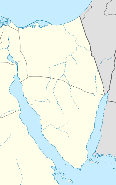
Deutsch: Positionskarte der Sinai-Halbinsel, Ägypten

Quadratische Plattkarte, N-S-Streckung 115 %. Geographische Begrenzung der Karte:

  • N: 31.7° N
  • S: 27.4° N
  • W: 32.1° O
  • O: 35.2° O
English: Location map of the Sinai Peninsula, Egypt

Equirectangular projection, N/S stretching 115 %. Geographic limits of the map:

  • N: 31.7° N
  • S: 27.4° N
  • W: 32.1° E
  • E: 35.2° E
ڕێکەوت
سەرچاوە

بەرھەمی خۆم, using

  • United States National Imagery and Mapping Agency data
  • World Data Base II data
بەرھەمھێنەر NordNordWest
ڕێپێدان
(بەکارھێنانەوەی ئەم پەڕگەیە)

I have published this file as author NordNordWest under the "CC-BY-SA-3.0-DE" in Wikipedia. This means that free, commercial usage outside of Wikipedia is permitted under the following licence terms:

Please send me a specimen copy or the URL of the website where the file is used.

Please write an email to nnwest[at]web.de if you

  • need my postal address for sending a specimen copy
  • have further questions about the terms of the licence

PS: In case of refusal of the above terms the author reserves the right to take legal action.

w:en:Creative Commons
دانەپاڵ بڵاوکردنەوەی گونجاو
This file is licensed under the Creative Commons Attribution-Share Alike 3.0 Germany license.
تۆ ئازادی:
  • بۆ بڵاکردنەوە – بۆ کۆپی کردن، دابەشکردن و دەستبەدەست ناردنی
  • بۆ تێکەڵکردنەوە – بۆ سازاندنی کارەکە
بەم مەرجانەی خوارەوە:
  • دانەپاڵ – پێویستە باوەڕی گونجاو بدەیت، بەستەرێک بۆ مۆڵەتەکە دابین بکەیت و ئاماژە بەوە بکەیت کە ئایا گۆڕانکاری کراوە یان نا. دەتوانیت بە هەر شێوەیەکی گونجاو ئەوە بکەیت، بەڵام بە شێوەیەک نا کە وا دەربکەوێت کە مۆڵەتدەر پشتگیری تۆ یان بەکارهێنانەکەت بکات.
  • بڵاوکردنەوەی گونجاو – ئەگەر لەسەر بنەمای ئەم کارە تێکەڵ، گۆڕان، یان ساز بکەی، پێویستە بەشدارییەکانت بە هەمان مۆڵەت یان هاوشێوەی مۆڵەتی ئەسڵی دابەش بکەی.
Kartenwerkstatt
This map has been made or improved in the German Kartenwerkstatt (Map Lab). You can propose maps to improve as well.

لێدوانەکان

Add a one-line explanation of what this file represents

بەندەکانی لەم پەڕگەیەدا دەردەکەون

depicts ئینگلیزی

٢٣ شوباتی 2010

source of file ئینگلیزی

مێژووی پەڕگە

کرتە بکە لەسەر یەکێک لە ڕێکەوت/کاتەکان بۆ بینینی پەڕگەکە بەو شێوەی لەو کاتەدا بووە.

ڕێکەوت/کاتھێمائەندازەبەکارھێنەرتێبینی
هەنووکە‏١٩:١٢، ٢٣ی شوباتی ٢٠١٠ھێما بۆ وەشانی  ‏١٩:١٢، ٢٣ی شوباتی ٢٠١٠٤٩٩ لە ٧٩٦ (٢١٩ کیلۆبایت)NordNordWest=={{int:filedesc}}== {{Information |Description= {{de|Positionskarte der Sinai-Halbinsel, Ägypten}} Quadratische Plattkarte, N-S-Streckung 115 %. Geographische Begrenzung der Karte: * N: 31.7° N * S: 27.4° N * W

ئەم پەڕەیە ئەم پەڕگەیە بەکار دەھێنێت:

بەکارھێنانی سەرانسەریی پەڕگە

ئەم ویکیانەی دیکەی خوارەوەش ئەم پەڕگە بەکاردێنن:

بینینی بەکارھێنانی گشتی زیاتری ئەم پەڕگەیە.