پەڕگە:Dasht-e Lut Dust Storm Iran TMO 2010023 lrg.jpg

قەبارەی ئەم پێشبینینە: ٤٥٠ لە ٦٠٠ پیکسەڵ. ڕێزەلووشنەکانی تر: ١٨٠ لە ٢٤٠ پیکسەڵ | ٣٦٠ لە ٤٨٠ پیکسەڵ | ٥٧٦ لە ٧٦٨ پیکسەڵ | ٧٦٨ لە ١٬٠٢٤ پیکسەڵ | ٢٬٤٠٠ لە ٣٬٢٠٠ پیکسەڵ.
پەڕگەی سەرەکی (٢٬٤٠٠ × ٣٬٢٠٠ پیکسڵ، قەبارەی پەڕگە: ١٫٣٥ مێگابایت، جۆری ئێم ئای ئێم ئی: image/jpeg)
کورتە
| وەسف |
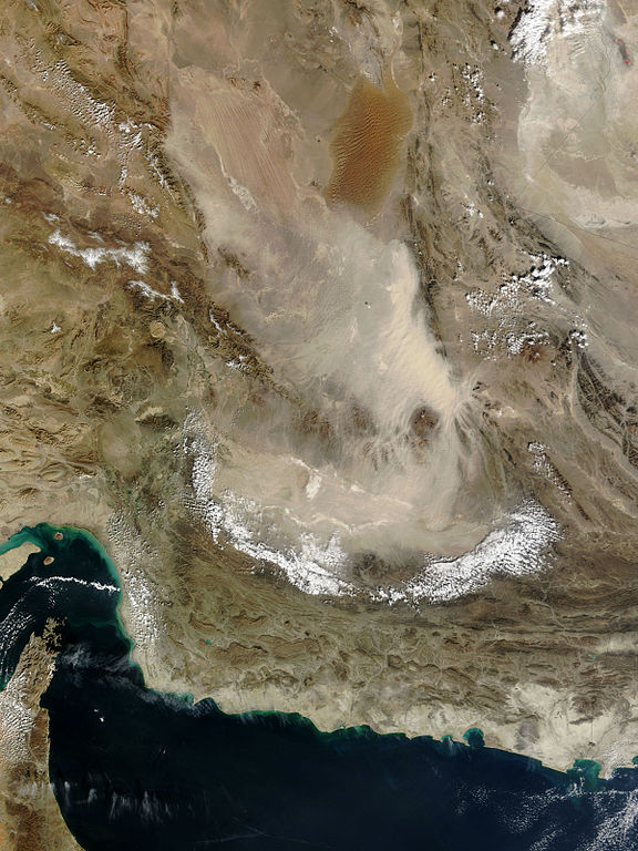
English: Pale tan dust billows over the Dasht-e Lut in eastern Iran, in this photo-like image from the Moderate Resolution Imaging Spectroradiometer (MODIS) on NASA’s Terra satellite. In the thickest part of the storm, the dust cloud blurs the texture of the land beneath it, revealing instead the texture of the air in waves and lines. The most distinctive waves surround Kuh-e Bazman, a 3,489-meter (11,450-foot) tall volcano, which rises above the dust cloud. The ripples in the dust are a reflection of turbulence created as air flows around the peak. The dust seeps into the valleys of the mountains south and east of the volcano.
The Dasht-e Lut, is a large salt desert in remote eastern Iran. The dust storm blows across the southern desert, leaving clear the distinctive orange dune fields and wind-swept lines in the north. |
| ڕێکەوت | |
| سەرچاوە | http://earthobservatory.nasa.gov/NaturalHazards/view.php?id=42443&src=nha |
| بەرھەمھێنەر | NASA |
== Assessment ==
|
مۆڵەتنامە
| This file is in the public domain in the United States because it was solely created by NASA. NASA copyright policy states that "NASA material is not protected by copyright unless noted". (See Template:PD-USGov, NASA copyright policy page or JPL Image Use Policy.) | ||
 |
Warnings:
|
مێژووی پەڕگە
کرتە بکە لەسەر یەکێک لە ڕێکەوت/کاتەکان بۆ بینینی پەڕگەکە بەو شێوەی لەو کاتەدا بووە.
| ڕێکەوت/کات | ھێما | ئەندازە | بەکارھێنەر | تێبینی | |
|---|---|---|---|---|---|
| هەنووکە | ١٩:٣٢، ٢٧ی کانوونی دووەمی ٢٠١٠ | | ٢٬٤٠٠ لە ٣٬٢٠٠ (١٫٣٥ مێگابایت) | Captain-tucker | {{Information |Description={{en|Pale tan dust billows over the Dasht-e Lut in eastern Iran, in this photo-like image from the Moderate Resolution Imaging Spectroradiometer (MODIS) on NASA’s Terra satellite. In the thickest part of the storm, the dust cl |
بەکارھێنانی پەڕگە
ئەم پەڕەیە ئەم پەڕگەیە بەکار دەھێنێت:
بەکارھێنانی سەرانسەریی پەڕگە
ئەم ویکیانەی دیکەی خوارەوەش ئەم پەڕگە بەکاردێنن:
- بەکارھێنان لە af.wikipedia.org
- بەکارھێنان لە cs.wikipedia.org
- بەکارھێنان لە fa.wikipedia.org
- دریای عمان
- دشت لوت
- بحث:دشت لوت
- تصویربرداری ماهوارهای
- ویکیپدیا:نگارههای برگزیده/نگاه به زمین
- ویکیپدیا:نگاره روز/ژوئن ۲۰۱۶
- ویکیپدیا:آیا میدانستید که...؟/هفتههای ۲۰۱۷ (میلادی)
- ویکیپدیا:آیا میدانستید که...؟/۲۰۱۷/هفته ۰۳
- ویکیپدیا:گزیدن نگاره برگزیده/Dasht-e Lut Dust Storm Iran TMO 2010023 lrg.jpg
- الگو:نر/2016-06-22
- الگو:نر محافظت شده/2016-06-22
- بحث ویکیپدیا:آیا میدانستید که...؟/۲۰۱۷/هفته ۰۳
- بەکارھێنان لە he.wikipedia.org
- بەکارھێنان لە mn.wikipedia.org
- بەکارھێنان لە sk.wikipedia.org