پەڕگە:Dardanelles landsat.jpg
رەزۆلوشنی سەرتر لەمە لە بەردەست دا نیە.
Dardanelles_landsat.jpg (٧٣٧ × ٥٨٤ پیکسڵ، قەبارەی پەڕگە: ٥٩٣ کیلۆبایت، جۆری ئێم ئای ئێم ئی: image/jpeg)
کورتە
| وەسف |
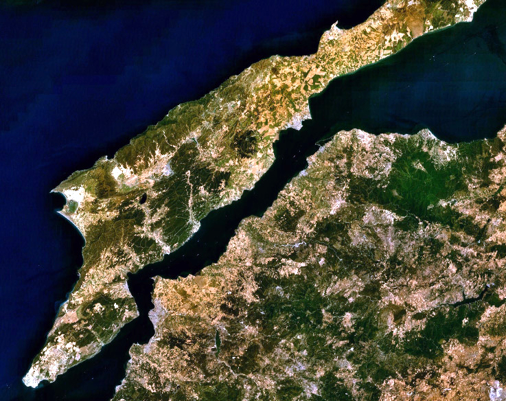
English: Landsat 7 image of the Dardanelles and Gallipoli Peninsula, Turkey. |
|||
| ڕێکەوت | ||||
| سەرچاوە | Captured and cropped from NASA World Wind. | |||
| بەرھەمھێنەر | NASA | |||
| ڕێپێدان (بەکارھێنانەوەی ئەم پەڕگەیە) |
|

مێژووی پەڕگە
کرتە بکە لەسەر یەکێک لە ڕێکەوت/کاتەکان بۆ بینینی پەڕگەکە بەو شێوەی لەو کاتەدا بووە.
| ڕێکەوت/کات | ھێما | ئەندازە | بەکارھێنەر | تێبینی | |
|---|---|---|---|---|---|
| هەنووکە | ٠٣:٠٦، ٢٦ی ئەیلوولی ٢٠١٣ | | ٧٣٧ لە ٥٨٤ (٥٩٣ کیلۆبایت) | Jahoe | improved colour |
| ١٢:٥٣، ١٧ی ئەیلوولی ٢٠٠٦ |  | ٧٣٧ لە ٥٨٤ (٢٠٥ کیلۆبایت) | ChrisO | NASA Landsat 7 image of the Dardanelles and Gallipoli Peninsula, Turkey. Category:Satellite images of peninsulas |
بەکارھێنانی پەڕگە
ئەم پەڕەیە ئەم پەڕگەیە بەکار دەھێنێت:
بەکارھێنانی سەرانسەریی پەڕگە
ئەم ویکیانەی دیکەی خوارەوەش ئەم پەڕگە بەکاردێنن:
- بەکارھێنان لە af.wikipedia.org
- بەکارھێنان لە an.wikipedia.org
- بەکارھێنان لە ar.wikipedia.org
- بەکارھێنان لە arz.wikipedia.org
- بەکارھێنان لە ast.wikipedia.org
- بەکارھێنان لە azb.wikipedia.org
- بەکارھێنان لە be-tarask.wikipedia.org
- بەکارھێنان لە be.wikipedia.org
- بەکارھێنان لە bg.wikipedia.org
- بەکارھێنان لە bo.wikipedia.org
- بەکارھێنان لە ca.wikipedia.org
- بەکارھێنان لە ceb.wikipedia.org
- بەکارھێنان لە co.wikipedia.org
- بەکارھێنان لە cs.wikipedia.org
- بەکارھێنان لە cy.wikipedia.org
- بەکارھێنان لە de.wikipedia.org
- بەکارھێنان لە el.wikipedia.org
- بەکارھێنان لە en.wikipedia.org
- بەکارھێنان لە eo.wikipedia.org
- بەکارھێنان لە eo.wikiquote.org
- بەکارھێنان لە es.wikipedia.org
- بەکارھێنان لە eu.wikipedia.org
- بەکارھێنان لە fa.wikipedia.org
- بەکارھێنان لە fr.wikipedia.org
- بەکارھێنان لە ga.wikipedia.org
- بەکارھێنان لە gl.wikipedia.org
- بەکارھێنان لە he.wikipedia.org
- بەکارھێنان لە ja.wikipedia.org
- بەکارھێنان لە kk.wikipedia.org
- بەکارھێنان لە ku.wikipedia.org
- بەکارھێنان لە ky.wikipedia.org
- بەکارھێنان لە lb.wikipedia.org
- بەکارھێنان لە nn.wikipedia.org
- بەکارھێنان لە no.wikipedia.org
- بەکارھێنان لە pl.wikipedia.org
- بەکارھێنان لە pl.wiktionary.org
بینینی بەکارھێنانی گشتی زیاتری ئەم پەڕگەیە.