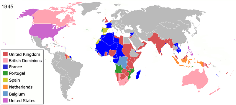
پەڕگە:Colonization 1945.png

قەبارەی ئەم پێشبینینە: ٨٠٠ لە ٣٥٥ پیکسەڵ. ڕێزەلووشنەکانی تر: ٣٢٠ لە ١٤٢ پیکسەڵ | ٦٤٠ لە ٢٨٤ پیکسەڵ | ١٬٤٣٨ لە ٦٣٨ پیکسەڵ.
پەڕگەی سەرەکی (١٬٤٣٨ × ٦٣٨ پیکسڵ، قەبارەی پەڕگە: ٨٥ کیلۆبایت، جۆری ئێم ئای ئێم ئی: image/png)
مێژووی پەڕگە
کرتە بکە لەسەر یەکێک لە ڕێکەوت/کاتەکان بۆ بینینی پەڕگەکە بەو شێوەی لەو کاتەدا بووە.
| ڕێکەوت/کات | ھێما | ئەندازە | بەکارھێنەر | تێبینی | |
|---|---|---|---|---|---|
| هەنووکە | ١٧:٢٠، ٢٨ی حوزەیرانی ٢٠١٩ |  | ١٬٤٣٨ لە ٦٣٨ (٨٥ کیلۆبایت) | Andres.tv | Recovering the large size of the image and improving the color for France. |
| ٢٢:٠٨، ٢٠ی تەممووزی ٢٠١٨ |  | ٨٠٠ لە ٣٥٥ (١٫٠٩ مێگابایت) | SuperSucker | UK | |
| ٠٧:٤٢، ١٠ی ئابی ٢٠١٦ |  | ١٬٤٣٨ لە ٦٣٨ (٩٢ کیلۆبایت) | Sebastiano Mugnaio | Reverted to version as of 14:08, 26 August 2012 (UTC) - sorry, meant this one... | |
| ٠٧:٤١، ١٠ی ئابی ٢٠١٦ |  | ١٬٤٣٨ لە ٦٣٨ (٩٢ کیلۆبایت) | Sebastiano Mugnaio | Reverted to version as of 14:08, 26 August 2012 (UTC) - Japan and Germany as colonies is rather awkward. | |
| ١٠:٥٨، ١٤ی ئابی ٢٠١٥ |  | ١٬٤٣٨ لە ٦٣٨ (٨٩ کیلۆبایت) | Palaeozoic99 | Fixed Newfoundland; it was a British Dominion from 1907-1949. | |
| ١٨:٥٦، ١١ی ئابی ٢٠١٥ |  | ١٬٤٣٨ لە ٦٣٨ (١٠٣ کیلۆبایت) | Alghenius | Corrected | |
| ١٤:٠٨، ٢٦ی ئابی ٢٠١٢ |  | ١٬٤٣٨ لە ٦٣٨ (٩٢ کیلۆبایت) | Hamodi1234 | Fixed Brazil | |
| ١٤:٠٥، ٢٦ی ئابی ٢٠١٢ |  | ١٬٤٣٨ لە ٦٣٨ (٩٢ کیلۆبایت) | Hamodi1234 | Fixed Brazil and Syria | |
| ١٤:٠٤، ٢٤ی تەممووزی ٢٠١٢ |  | ١٬٤٣٨ لە ٦٣٨ (٨١ کیلۆبایت) | Soerfm | Legend | |
| ٠٩:١٤، ٩ی حوزەیرانی ٢٠١٢ |  | ١٬٤٢٥ لە ٦٢٥ (٤٦ کیلۆبایت) | Ozzorro~commonswiki | Repositioned image and fixed colours to match other maps in the 'Colonisation' series (1492, 1550, 1660, 1754, 1800, 1822, 1885, 1914, 1938, 1959, 1974, 2007) - also corrected island positions. Suggestion: The 'British Dominions' classification exist... |
بەکارھێنانی پەڕگە
ھیچ پەڕەیەک نییە کە ئەم پەڕگەیە بەکاربھێنێت.
بەکارھێنانی سەرانسەریی پەڕگە
ئەم ویکیانەی دیکەی خوارەوەش ئەم پەڕگە بەکاردێنن:
- بەکارھێنان لە af.wikipedia.org
- بەکارھێنان لە am.wikipedia.org
- بەکارھێنان لە ar.wikipedia.org
- بەکارھێنان لە ast.wikipedia.org
- بەکارھێنان لە azb.wikipedia.org
- بەکارھێنان لە az.wikipedia.org
- بەکارھێنان لە be.wikipedia.org
- بەکارھێنان لە bg.wikipedia.org
- بەکارھێنان لە ca.wikipedia.org
- بەکارھێنان لە cs.wikipedia.org
- بەکارھێنان لە cy.wikipedia.org
- بەکارھێنان لە da.wikipedia.org
- بەکارھێنان لە de.wikipedia.org
- Zweiter Weltkrieg
- Kolonialmacht
- Dekolonisation
- Benutzer:HerbertErwin/Portal:Gesellschaftskritik/Dekolonisation
- Benutzer:HerbertErwin/Portal:Gesellschaftskritik/Unterseite 7
- Benutzer:Ulflulfl/Karten
- Travaux et mémoires de l’Institut d’ethnologie
- Benutzer:Casadopovo/EURAFRICA
- Mémoires de l’Institut d’ethnologie
- بەکارھێنان لە en.wikipedia.org
- Self-determination
- Free trade
- Atlantic Charter
- Decolonization
- Cold War
- User:Aris Katsaris
- History of Western civilization
- Aftermath of World War II
- History of colonialism
- Talk:World War II/Infobox/Archive 5
- Nazi propaganda and the United Kingdom
- User:Rlandale
- Western influence on Africa
- Wikipedia:Graphics Lab/Map workshop/Archive/Dec 2015
- Theories of imperialism
- User:Falcaorib
- بەکارھێنان لە en.wikibooks.org
- بەکارھێنان لە eo.wikipedia.org
بینینی بەکارھێنانی گشتی زیاتری ئەم پەڕگەیە.


