پەڕگە:1696 Genroku 9 (early Edo) Japanese Map of Kyoto, Japan - Geographicus - Kyoto-genroku9-1696.jpg

قەبارەی ئەم پێشبینینە: ٤٣٧ لە ٥٩٩ پیکسەڵ. ڕێزەلووشنەکانی تر: ١٧٥ لە ٢٤٠ پیکسەڵ | ٣٥٠ لە ٤٨٠ پیکسەڵ | ٥٦٠ لە ٧٦٨ پیکسەڵ | ٧٤٧ لە ١٬٠٢٤ پیکسەڵ | ١٬٤٩٤ لە ٢٬٠٤٨ پیکسەڵ | ٤٬٤٧٨ لە ٦٬١٣٩ پیکسەڵ.
پەڕگەی سەرەکی (٤٬٤٧٨ × ٦٬١٣٩ پیکسڵ، قەبارەی پەڕگە: ٦٫٩١ مێگابایت، جۆری ئێم ئای ئێم ئی: image/jpeg)
_Japanese_Map_of_Kyoto,_Japan_-_Geographicus_-_Kyoto-genroku9-1696.jpg)
| Kyoto. | ||||||
|---|---|---|---|---|---|---|
| ھونەرمەند | ||||||
| سەرناو |
Kyoto. |
|||||
| وەسف |
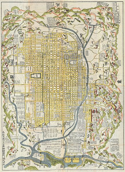
English: A rare 1696 Japanese woodblock map of Kyoto, Japan. Made in the early Edo period during the 9th year of Genroku era. Covers the city of Kyoto and its immediate vicinity. Like most early Japanese maps, this map does not have a firm directional orientation, rather all text radiates out from the center. Labels streets, waterways, mountains and important buildings. Despite 1696 date, it may be a reissue circa 1860, based upon the type of paper used. |
|||||
| ڕێکەوت | ١٦٩٦ (dated: Genroku 9, early Edo) | |||||
| Dimensions | بەرزایی: ٦٠٫٠ in (١٥٢٫٤ cm)؛ width: ٤٥٫٠ in (١١٤٫٣ cm) | |||||
| Accession number |
Geographicus link: Kyoto-genroku9-1696 |
|||||
| سەرچاوە/وێنەگر |
|
|||||
| ڕێپێدان (بەکارھێنانەوەی ئەم پەڕگەیە) |
|
|||||
مێژووی پەڕگە
کرتە بکە لەسەر یەکێک لە ڕێکەوت/کاتەکان بۆ بینینی پەڕگەکە بەو شێوەی لەو کاتەدا بووە.
| ڕێکەوت/کات | ھێما | ئەندازە | بەکارھێنەر | تێبینی | |
|---|---|---|---|---|---|
| هەنووکە | ١٥:٢٥، ٢٢ی ئازاری ٢٠١١ | | ٤٬٤٧٨ لە ٦٬١٣٩ (٦٫٩١ مێگابایت) | BotMultichillT | {{subst:User:Multichill/Geographicus |link=http://www.geographicus.com/P/AntiqueMap/Kyoto-genroku9-1696 |product_name=1696 Genroku 9 (early Edo) Japanese Map of Kyoto, Japan |map_title=Kyoto. |description=A rare and extraordinary 1696 Japanese woodblock m |
بەکارھێنانی پەڕگە
ئەم پەڕەیە ئەم پەڕگەیە بەکار دەھێنێت:
بەکارھێنانی سەرانسەریی پەڕگە
ئەم ویکیانەی دیکەی خوارەوەش ئەم پەڕگە بەکاردێنن:
- بەکارھێنان لە br.wikipedia.org
- بەکارھێنان لە de.wikipedia.org
- بەکارھێنان لە en.wikipedia.org
- بەکارھێنان لە es.wikipedia.org
- بەکارھێنان لە fr.wikipedia.org
- بەکارھێنان لە gl.wikipedia.org
- بەکارھێنان لە it.wikipedia.org
- بەکارھێنان لە ja.wikipedia.org
- بەکارھێنان لە ko.wikipedia.org
- بەکارھێنان لە pt.wikipedia.org
- بەکارھێنان لە ru.wikipedia.org
- بەکارھێنان لە simple.wikipedia.org
- بەکارھێنان لە sl.wikipedia.org
- بەکارھێنان لە sr.wikipedia.org
- بەکارھێنان لە sv.wikipedia.org
- بەکارھێنان لە vi.wikipedia.org
- بەکارھێنان لە www.wikidata.org
- بەکارھێنان لە zh.wikipedia.org
_Japanese_Map_of_Kyoto,_Japan_-_Geographicus_-_Kyoto-genroku9-1696.jpg)