پەڕگە:Urartu 715 713-en.svg

Size of this PNG preview of this SVG file: ٨٠٠ لە ٥١٣ پیکسەڵ. ڕێزەلووشنەکانی تر: ٣٢٠ لە ٢٠٥ پیکسەڵ | ٦٤٠ لە ٤١٠ پیکسەڵ | ١٬٠٢٤ لە ٦٥٧ پیکسەڵ | ١٬٢٨٠ لە ٨٢١ پیکسەڵ | ٢٬٥٦٠ لە ١٬٦٤١ پیکسەڵ | ٢٬٧١٤ لە ١٬٧٤٠ پیکسەڵ.
پەڕگەی سەرەکی (پەڕگەی SVG، بە ناو ٢٬٧١٤ × ١٬٧٤٠ پیکسەڵ، قەبارەی پەڕگە: ٨٨١ کیلۆبایت)
کورتە
| وەسف |
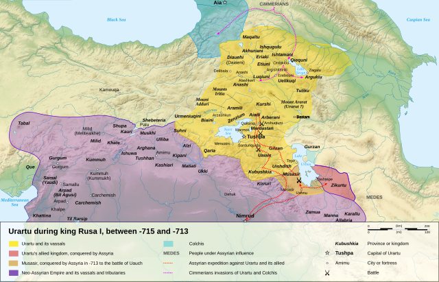
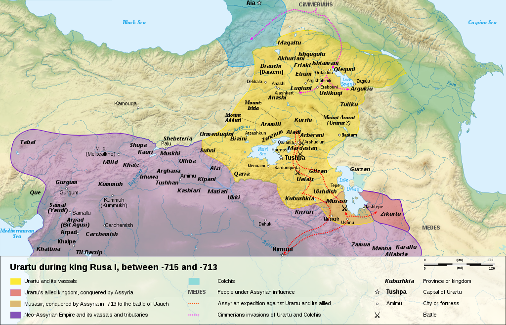
English: Map of the kingdom of Urartu, between -715 and -713.
Français : Carte en anglais du royaume d'Urartu, entre -715 et -713. |
||
| ڕێکەوت | |||
| سەرچاوە |
Own work.
Sources :
Software used :
Other data :
|
||
| بەرھەمھێنەر | Sémhur | ||
| وەشانەکانی تر |
See Urartu.
| ||
| دانەپاڵ (required by the license) | © Sémhur / Wikimedia Commons / | ||
| SVG | W3C-validity not checked.
|
||
| Atelier graphique |


| Camera location | | View this and other nearby images on: OpenStreetMap |
|---|
مۆڵەتنامە
من، ھەڵگری مافی لەبەرگرتنەوەی ئەم بەرھەمە، لەژێر ئەم مۆڵەتنامەیانەدا بڵاوی دەکەمەوە:
| Copyleft: This work of art is free; you can redistribute it and/or modify it according to terms of the Free Art License. You will find a specimen of this license on the Copyleft Attitude site as well as on other sites. |
This file is licensed under the Creative Commons Attribution-Share Alike 4.0 International, 3.0 Unported, 2.5 Generic, 2.0 Generic and 1.0 Generic license.
- تۆ ئازادی:
- بۆ بڵاکردنەوە – بۆ کۆپی کردن، دابەشکردن و دەستبەدەست ناردنی
- بۆ تێکەڵکردنەوە – بۆ سازاندنی کارەکە
- بەم مەرجانەی خوارەوە:
- دانەپاڵ – پێویستە باوەڕی گونجاو بدەیت، بەستەرێک بۆ مۆڵەتەکە دابین بکەیت و ئاماژە بەوە بکەیت کە ئایا گۆڕانکاری کراوە یان نا. دەتوانیت بە هەر شێوەیەکی گونجاو ئەوە بکەیت، بەڵام بە شێوەیەک نا کە وا دەربکەوێت کە مۆڵەتدەر پشتگیری تۆ یان بەکارهێنانەکەت بکات.
- بڵاوکردنەوەی گونجاو – ئەگەر لەسەر بنەمای ئەم کارە تێکەڵ، گۆڕان، یان ساز بکەی، پێویستە بەشدارییەکانت بە هەمان مۆڵەت یان هاوشێوەی مۆڵەتی ئەسڵی دابەش بکەی.
دەتوانی مۆڵەتنامەی دڵخوازت ھەڵبژێریت.
| Annotations | This image is annotated: View the annotations at Commons |
مێژووی پەڕگە
کرتە بکە لەسەر یەکێک لە ڕێکەوت/کاتەکان بۆ بینینی پەڕگەکە بەو شێوەی لەو کاتەدا بووە.
| ڕێکەوت/کات | ھێما | ئەندازە | بەکارھێنەر | تێبینی | |
|---|---|---|---|---|---|
| هەنووکە | ١٦:١٥، ١٠ی کانوونی دووەمی ٢٠٠٨ | | ٢٬٧١٤ لە ١٬٧٤٠ (٨٨١ کیلۆبایت) | Sémhur | == Description == {{Information |Description= {{en| Map of the kingdom of Urartu, between -715 and -713.}} {{fr| Carte en anglais du royaume d'Urartu, entre -715 et -713.}} |Source=Own work. {{clr}} Sources : * Topographic background : [http://www2.jpl.na |
بەکارھێنانی پەڕگە
ئەم پەڕەیە ئەم پەڕگەیە بەکار دەھێنێت:
بەکارھێنانی سەرانسەریی پەڕگە
ئەم ویکیانەی دیکەی خوارەوەش ئەم پەڕگە بەکاردێنن:
- بەکارھێنان لە als.wikipedia.org
- بەکارھێنان لە ast.wikipedia.org
- بەکارھێنان لە avk.wikipedia.org
- بەکارھێنان لە azb.wikipedia.org
- بەکارھێنان لە bg.wikipedia.org
- بەکارھێنان لە cs.wikipedia.org
- بەکارھێنان لە de.wikipedia.org
- بەکارھێنان لە en.wikipedia.org
- بەکارھێنان لە eo.wikipedia.org
- بەکارھێنان لە et.wikipedia.org
- بەکارھێنان لە fr.wikipedia.org
- بەکارھێنان لە fy.wikipedia.org
- بەکارھێنان لە gl.wikipedia.org
- بەکارھێنان لە hy.wikipedia.org
- بەکارھێنان لە id.wikipedia.org
- بەکارھێنان لە ja.wikipedia.org
- بەکارھێنان لە ka.wikipedia.org
- بەکارھێنان لە mt.wikipedia.org
- بەکارھێنان لە no.wikipedia.org
- بەکارھێنان لە pl.wikipedia.org
- بەکارھێنان لە pnb.wikipedia.org
- بەکارھێنان لە sl.wikipedia.org
- بەکارھێنان لە sr.wikipedia.org
بینینی بەکارھێنانی گشتی زیاتری ئەم پەڕگەیە.