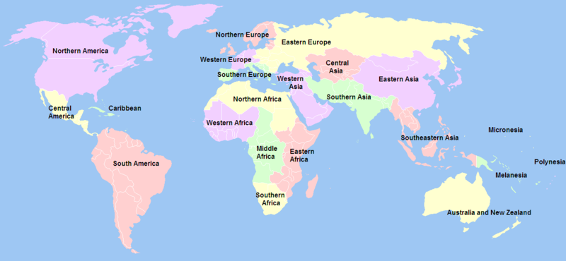
پەڕگە:United Nations geographical subregions.png

قەبارەی ئەم پێشبینینە: ٨٠٠ لە ٣٧٠ پیکسەڵ. ڕێزەلووشنەکانی تر: ٣٢٠ لە ١٤٨ پیکسەڵ | ٦٤٠ لە ٢٩٦ پیکسەڵ | ١٬٣٥٧ لە ٦٢٨ پیکسەڵ.
پەڕگەی سەرەکی (١٬٣٥٧ × ٦٢٨ پیکسڵ، قەبارەی پەڕگە: ٨١ کیلۆبایت، جۆری ئێم ئای ئێم ئی: image/png)
مێژووی پەڕگە
کرتە بکە لەسەر یەکێک لە ڕێکەوت/کاتەکان بۆ بینینی پەڕگەکە بەو شێوەی لەو کاتەدا بووە.
| ڕێکەوت/کات | ھێما | ئەندازە | بەکارھێنەر | تێبینی | |
|---|---|---|---|---|---|
| هەنووکە | ٠٣:٢٠، ٢١ی کانوونی یەکەمی ٢٠١٢ |  | ١٬٣٥٧ لە ٦٢٨ (٨١ کیلۆبایت) | Spacepotato | Revert to the version of 14 Jan, since in the current version of the UN geographic classification scheme, http://unstats.un.org/unsd/methods/m49/m49regin.htm , South Sudan has been placed in Eastern Africa. |
| ٠٨:٣٦، ٢٤ی کانوونی دووەمی ٢٠١٢ |  | ١٬٣٥٧ لە ٦٢٨ (٦٠ کیلۆبایت) | Quintucket | Does it make sense to include South Sudan in East Africa? Yes. Does the United Nations usually do things on the ground that they make sense? No. For now, at least South Sudan is "North Africa" as far as the UN is concerned. | |
| ١٥:٢٧، ١٤ی کانوونی دووەمی ٢٠١٢ |  | ١٬٣٥٧ لە ٦٢٨ (٨١ کیلۆبایت) | Дмитрий-5-Аверин | Южный Судан | |
| ٠٢:١٥، ١٧ی شوباتی ٢٠١٠ |  | ١٬٣٥٧ لە ٦٢٨ (٨١ کیلۆبایت) | Stevanb | I don't see any reason why Kosovo should be listed here because it is not UN recognized country and this is UN geoscheme. | |
| ١٧:٢١، ١٥ی شوباتی ٢٠١٠ |  | ١٬٣٥٧ لە ٦٢٨ (٦٣ کیلۆبایت) | Dwo | Reverted to version as of 14:34, 18 October 2008 | |
| ١٨:١٥، ٦ی کانوونی یەکەمی ٢٠٠٩ |  | ١٬٣٥٧ لە ٦٢٨ (٦٣ کیلۆبایت) | Keepscases | Reverted to version as of 03:00, 3 July 2006 | |
| ١٤:٣٤، ١٨ی تشرینی یەکەمی ٢٠٠٨ |  | ١٬٣٥٧ لە ٦٢٨ (٦٣ کیلۆبایت) | IJA | + Montenegro as UN member. | |
| ٠٠:١٩، ٧ی کانوونی یەکەمی ٢٠٠٦ |  | ١٬٣٥٧ لە ٦٢٨ (٥٦ کیلۆبایت) | Psychlopaedist | Reverted to earlier revision | |
| ٠٠:١٨، ٧ی کانوونی یەکەمی ٢٠٠٦ |  | ١٬٣٥٧ لە ٦٢٨ (٥٦ کیلۆبایت) | Psychlopaedist | Reverted to earlier revision | |
| ٠٣:٠٠، ٣ی تەممووزی ٢٠٠٦ |  | ١٬٣٥٧ لە ٦٢٨ (٦٣ کیلۆبایت) | Mexicano~commonswiki | This image was copied from wikipedia:en. The original description was: == Summary == Created by User:Ben Arnold, edited by User:E Pluribus Anthony, from Image:BlankMap-World.png. Information about geographical subregions was obtained from ht |
بەکارھێنانی پەڕگە
ئەم پەڕەیە ئەم پەڕگەیە بەکار دەھێنێت:
بەکارھێنانی سەرانسەریی پەڕگە
ئەم ویکیانەی دیکەی خوارەوەش ئەم پەڕگە بەکاردێنن:
- بەکارھێنان لە an.wikipedia.org
- بەکارھێنان لە ar.wikipedia.org
- بەکارھێنان لە az.wikipedia.org
- بەکارھێنان لە ban.wikipedia.org
- بەکارھێنان لە bbc.wikipedia.org
- بەکارھێنان لە bg.wikipedia.org
- بەکارھێنان لە bn.wikipedia.org
- بەکارھێنان لە da.wikipedia.org
- بەکارھێنان لە en.wikipedia.org
- Talk:Melanesia
- Talk:Southern Europe
- Subregion
- User:Big Adamsky
- Wikipedia talk:WikiProject Aviation/Airline destination lists
- User:Nightstallion/sandbox
- Talk:Oceania/Archive 2
- User:Lilliputian/navel ring
- User:Nurg/Continent
- United Nations geoscheme
- Talk:List of European tornadoes and tornado outbreaks
- Talk:Asian Americans/Archive 2
- User:Patrick/Asia
- Talk:2007 FIBA Americas Championship
- Talk:Ethnic groups in Europe/Archive 1
- Wikipedia talk:WikiProject International relations/Archive 2
- List of countries by population (United Nations)
- User:DexDor/Categorization of organisms by geography
- Talk:West Asia/Archive 1
- بەکارھێنان لە es.wikipedia.org
- بەکارھێنان لە et.wikipedia.org
- بەکارھێنان لە fr.wikipedia.org
- بەکارھێنان لە hy.wikipedia.org
- بەکارھێنان لە it.wikipedia.org
بینینی بەکارھێنانی گشتی زیاتری ئەم پەڕگەیە.


