پەڕگە:Umbriel (moon).jpg
رەزۆلوشنی سەرتر لەمە لە بەردەست دا نیە.
Umbriel_(moon).jpg (٢٩١ × ٣٠٢ پیکسڵ، قەبارەی پەڕگە: ٢٥ کیلۆبایت، جۆری ئێم ئای ئێم ئی: image/jpeg)
.jpg)
کورتە
| وەسف |
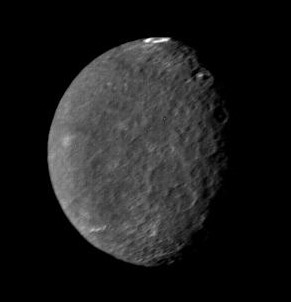
English: Original Caption Released with Image: The southern hemisphere of Umbriel displays heavy cratering in this Voyager 2 image, taken Jan. 24, 1986, from a distance of 557,000 kilometers (346,000 miles). This frame, taken through the clear-filter of Voyager's narrow-angle camera, is the most detailed image of Umbriel, with a resolution of about 10 km (6 mi). Umbriel is the darkest of Uranus' larger moons and the one that appears to have experienced the lowest level of geological activity. It has a diameter of about 1,200 km (750 mi) and reflects only 16 percent of the light striking its surface; in the latter respect, Umbriel is similar to lunar highland areas. Umbriel is heavily cratered but lacks the numerous bright ray craters seen on the other large Uranian satellites; this results in a relatively uniform surface albedo (reflectivity). The prominent crater on the terminator (upper right) is about 110 km (70 mi) across and has a bright central peak. The strangest feature in this image (at top) is a curious bright ring, the most reflective area seen on Umbriel. The ring is about 140 km (90 miles) in diameter and lies near the satellite's equator. The nature of the ring is not known, although it might be a frost deposit, perhaps associated with an impact crater. Spots against the black background are due to 'noise' in the data. The Voyager project is managed for NASA by the Jet Propulsion Laboratory. |
| ڕێکەوت | |
| سەرچاوە | http://photojournal.jpl.nasa.gov/catalog/PIA00040 |
| بەرھەمھێنەر | NASA |
| وەشانەکانی تر | larger size version |
مۆڵەتنامە
| This file is in the public domain in the United States because it was solely created by NASA. NASA copyright policy states that "NASA material is not protected by copyright unless noted". (See Template:PD-USGov, NASA copyright policy page or JPL Image Use Policy.) | ||
 |
Warnings:
|
مێژووی پەڕگە
کرتە بکە لەسەر یەکێک لە ڕێکەوت/کاتەکان بۆ بینینی پەڕگەکە بەو شێوەی لەو کاتەدا بووە.
| ڕێکەوت/کات | ھێما | ئەندازە | بەکارھێنەر | تێبینی | |
|---|---|---|---|---|---|
| هەنووکە | ٢٣:٠٨، ١٤ی ئابی ٢٠٠٥ | | ٢٩١ لە ٣٠٢ (٢٥ کیلۆبایت) | Vzb83~commonswiki | cropped image |
| ١٨:٤٤، ٣٠ی نیسانی ٢٠٠٥ |  | ٤٠٠ لە ٤٠٠ (٧ کیلۆبایت) | Bricktop | uploaded missing image | |
| ٢١:١٨، ٤ی نیسانی ٢٠٠٥ |  | ٢٥٢ لە ٢٥٢ (٢٤ کیلۆبایت) | Smartech~commonswiki | '''Original Caption Released with Image''': The southern hemisphere of Umbriel displays heavy cratering in this Voyager 2 image, taken Jan. 24, 1986, from a distance of 557,000 kilometers (346,000 miles). This frame, |
بەکارھێنانی پەڕگە
ئەم پەڕەیە ئەم پەڕگەیە بەکار دەھێنێت:
بەکارھێنانی سەرانسەریی پەڕگە
ئەم ویکیانەی دیکەی خوارەوەش ئەم پەڕگە بەکاردێنن:
- بەکارھێنان لە af.wikipedia.org
- بەکارھێنان لە als.wikipedia.org
- بەکارھێنان لە ar.wikipedia.org
- بەکارھێنان لە ast.wikipedia.org
- بەکارھێنان لە az.wikipedia.org
- بەکارھێنان لە be-tarask.wikipedia.org
- بەکارھێنان لە bg.wikipedia.org
- بەکارھێنان لە ca.wikipedia.org
- بەکارھێنان لە ceb.wikipedia.org
- بەکارھێنان لە cs.wikipedia.org
- بەکارھێنان لە cy.wikipedia.org
- بەکارھێنان لە da.wikipedia.org
- بەکارھێنان لە de.wikipedia.org
- بەکارھێنان لە de.wikibooks.org
- بەکارھێنان لە el.wikipedia.org
- بەکارھێنان لە en.wikipedia.org
- بەکارھێنان لە eo.wikipedia.org
- بەکارھێنان لە es.wikipedia.org
- بەکارھێنان لە et.wikipedia.org
- بەکارھێنان لە eu.wikipedia.org
- بەکارھێنان لە fa.wikipedia.org
- بەکارھێنان لە fi.wikipedia.org
- بەکارھێنان لە fr.wikipedia.org
بینینی بەکارھێنانی گشتی زیاتری ئەم پەڕگەیە.
.jpg)
.jpg)