پەڕگە:TochigiMapCurrent.png

قەبارەی ئەم پێشبینینە: ٦٦٦ لە ٥٩٩ پیکسەڵ. ڕێزەلووشنەکانی تر: ٢٦٧ لە ٢٤٠ پیکسەڵ | ٥٣٣ لە ٤٨٠ پیکسەڵ | ١٬٠٠١ لە ٩٠١ پیکسەڵ.
پەڕگەی سەرەکی (١٬٠٠١ × ٩٠١ پیکسڵ، قەبارەی پەڕگە: ٤٠ کیلۆبایت، جۆری ئێم ئای ئێم ئی: image/png)
کورتە
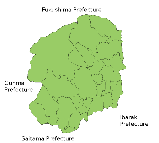
Map of Tochigi Prefecture, Japan.
Thanks to Aoki Shigenobu and [1]. Colors from Image:TokyoMapCurrent.png by User:Fg2.
مۆڵەتنامە

|
Shigenobu AOKI, the copyright holder of this work, allows anyone to use it for any purpose including unrestricted redistribution, commercial use, and modification.
|
مێژووی پەڕگە
کرتە بکە لەسەر یەکێک لە ڕێکەوت/کاتەکان بۆ بینینی پەڕگەکە بەو شێوەی لەو کاتەدا بووە.
| ڕێکەوت/کات | ھێما | ئەندازە | بەکارھێنەر | تێبینی | |
|---|---|---|---|---|---|
| هەنووکە | ١٥:٥٤، ٢٧ی حوزەیرانی ٢٠١٥ | | ١٬٠٠١ لە ٩٠١ (٤٠ کیلۆبایت) | Virata2 | Tochigi City absorbed the town of Iwafune in April, 2014. |
| ٢٠:٢٩، ٣٠ی ئەیلوولی ٢٠١١ |  | ١٬٠٠١ لە ٩٠١ (٣١ کیلۆبایت) | Haaninjo | Update for mergers into Tochigi and Mo'oka | |
| ٠٣:٠٢، ١٣ی حوزەیرانی ٢٠٠٧ |  | ١٬٠٠١ لە ٩٠١ (٣٤ کیلۆبایت) | Alberth2 | Kamikawachi Town and Kawachi Town have merged into Utsunomiya City. | |
| ٠٥:٠٢، ١٩ی تەممووزی ٢٠٠٦ |  | ١٬٠٠١ لە ٩٠١ (٣٢ کیلۆبایت) | Akanemoto~commonswiki | Map of Tochigi Prefecture, Japan. Thanks to Aoki Shigenobu and [http://aoki2.si.gunma-u.ac.jp/map/map.html]. Colors from Image:TokyoMapCurrent.png by User:Fg2. Category:Maps of Tochigi prefecture Category:Maps in English |
بەکارھێنانی پەڕگە
ئەم پەڕەیە ئەم پەڕگەیە بەکار دەھێنێت:
بەکارھێنانی سەرانسەریی پەڕگە
ئەم ویکیانەی دیکەی خوارەوەش ئەم پەڕگە بەکاردێنن:
- بەکارھێنان لە az.wikipedia.org
- بەکارھێنان لە cs.wikipedia.org
- بەکارھێنان لە fa.wikipedia.org
- بەکارھێنان لە lt.wikipedia.org
- بەکارھێنان لە no.wikipedia.org
- بەکارھێنان لە ru.wikipedia.org
- بەکارھێنان لە vi.wikipedia.org