پەڕگە:Sub-Saharan Africa definition UN.png
رەزۆلوشنی سەرتر لەمە لە بەردەست دا نیە.
Sub-Saharan_Africa_definition_UN.png (٣٦٢ × ٣٤٠ پیکسڵ، قەبارەی پەڕگە: ٦ کیلۆبایت، جۆری ئێم ئای ئێم ئی: image/png)

|
This map image could be re-created using vector graphics as an SVG file. This has several advantages; see Commons:Media for cleanup for more information. If an SVG form of this image is available, please upload it and afterwards replace this template with
{{vector version available|new image name}}.
It is recommended to name the SVG file “Sub-Saharan Africa definition UN.svg”—then the template Vector version available (or Vva) does not need the new image name parameter. |
| وەسف |
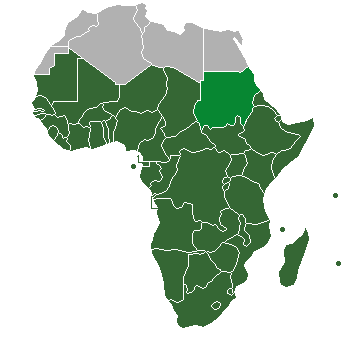
Definition of "Sub-Saharan Africa" as used in the statistics of many the UN institutions. Sudan is also classified as North Africa by the United Nations. |
| ڕێکەوت | (UTC) |
| سەرچاوە | |
| بەرھەمھێنەر |
| This is a retouched picture, which means that it has been digitally altered from its original version. Modifications: binary colouring of countries. The original can be viewed here: HDImap spectrum2006 Africa.png:
|
من، ھەڵگری مافی لەبەرگرتنەوەی ئەم بەرھەمە، لەژێر ئەم مۆڵەتنامەیەدا بڵاوی دەکەمەوە:
| من، هەڵگری مافی لەبەرگرتنەوەی ئەم بەرھەمە، ئەم بەرھەمە بڵاودەکەمەوە بۆ پاوانی گشتی (public domain). ئەم مافە بۆ سەرانسەری جیھانە. لە ھەندێ وڵاتدا لەوانەیە یاسا، ڕێگە بەمە نەدات؛ لەو کاتەدا: من مافی بەکارھێنانی ئەم بەرھەمە بۆ ھەر مەبەستێک دەبەخشم بە ھەموو کەسێک، بێ ھیچ مەرجێک، مەگەر ئەو چەشنە مەرجانە کە یاسا ھەبوونیانی بە پێویستی بزانێت. |
Original upload log
This image is a derivative work of the following images:
- File:HDImap_spectrum2006_Africa.png licensed with PD-self
- 2007-03-09T10:43:40Z Dbachmann 356x344 (7521 Bytes) == Summary == Detail of [[:Image:HDImap spectrum2006.png]]. [[:en:United Natiows|UN]] [[:en:Human Development Index|Human Development Index (HDI)]] for 2004, derived from 2006 UN HDI report. An HDI below 0.5 is considered to
Uploaded with derivativeFX
مێژووی پەڕگە
کرتە بکە لەسەر یەکێک لە ڕێکەوت/کاتەکان بۆ بینینی پەڕگەکە بەو شێوەی لەو کاتەدا بووە.
| ڕێکەوت/کات | ھێما | ئەندازە | بەکارھێنەر | تێبینی | |
|---|---|---|---|---|---|
| هەنووکە | ٢٠:٤٧، ١٩ی تەممووزی ٢٠١٣ | | ٣٦٢ لە ٣٤٠ (٦ کیلۆبایت) | Maproom | Reshaded South Sudan, which the UN now regards as in East Africa, not North Africa: see http://unstats.un.org/unsd/methods/m49/m49regin.htm |
| ١٣:٢٧، ١٢ی نیسانی ٢٠١٢ |  | ٣٦٢ لە ٣٤٠ (٩ کیلۆبایت) | Hazhk | Adding different shading for Sudan & S. Sudan because they're also classified as being part of North Africa by the UN | |
| ٢٢:٠٢، ٩ی تەممووزی ٢٠١١ |  | ٣٥٦ لە ٣٤٤ (١١ کیلۆبایت) | Maphobbyist | South Sudan has become independent on July 9, 2011. Sudan and South Sudan are shown with the new international border between them. | |
| ٠٦:٤٦، ٣١ی ئازاری ٢٠١١ |  | ٣٥٦ لە ٣٤٤ (١٠ کیلۆبایت) | Hoshie | added Cabinda (Angola) to map | |
| ١١:١٨، ١٥ی کانوونی یەکەمی ٢٠١٠ |  | ٣٥٦ لە ٣٤٤ (٦ کیلۆبایت) | Jcherlet | {{Information |Description=Definition of Sub-Saharan Africa, according to the United Nations institutions |Source=*File:HDImap_spectrum2006_Africa.png |Date=2010-12-15 11:13 (UTC) |Author=*Jcherlet: '''Jcherlet''' *derivative work: |
بەکارھێنانی پەڕگە
ئەم پەڕەیە ئەم پەڕگەیە بەکار دەھێنێت:
بەکارھێنانی سەرانسەریی پەڕگە
ئەم ویکیانەی دیکەی خوارەوەش ئەم پەڕگە بەکاردێنن:
- بەکارھێنان لە ast.wikipedia.org
- بەکارھێنان لە ca.wikipedia.org
- بەکارھێنان لە cs.wikipedia.org
- بەکارھێنان لە de.wikipedia.org
- بەکارھێنان لە en.wikipedia.org
- Sub-Saharan Africa
- Water supply and sanitation in sub-Saharan Africa
- Wikipedia:Reference desk/Archives/Humanities/2013 October 5
- Category:Birds of Sub-Saharan Africa
- Category:Fauna of Sub-Saharan Africa
- Category:Biota of Sub-Saharan Africa
- Category:Mammals of Sub-Saharan Africa
- User:DexDor/Categorization of organisms by geography
- Category:Moths of Sub-Saharan Africa
- Category:Amphibians of Sub-Saharan Africa
- بەکارھێنان لە et.wikipedia.org
- بەکارھێنان لە ha.wikipedia.org
- بەکارھێنان لە he.wikipedia.org
- بەکارھێنان لە id.wikipedia.org
- بەکارھێنان لە ig.wikipedia.org
- بەکارھێنان لە ilo.wikipedia.org
- بەکارھێنان لە it.wikipedia.org
- بەکارھێنان لە ja.wikipedia.org
- بەکارھێنان لە ka.wikipedia.org
- بەکارھێنان لە ko.wikipedia.org
- بەکارھێنان لە lt.wikipedia.org
- بەکارھێنان لە pa.wikipedia.org
- بەکارھێنان لە pnb.wikipedia.org
- بەکارھێنان لە ro.wikipedia.org
- بەکارھێنان لە simple.wikipedia.org
- بەکارھێنان لە sr.wikipedia.org
- بەکارھێنان لە sv.wikipedia.org
- بەکارھێنان لە ta.wikipedia.org
- بەکارھێنان لە th.wikipedia.org
- بەکارھێنان لە tn.wikipedia.org
- بەکارھێنان لە tr.wikipedia.org
- بەکارھێنان لە ur.wikipedia.org
بینینی بەکارھێنانی گشتی زیاتری ئەم پەڕگەیە.