پەڕگە:Sana in Bosnia and Hercegovina map.png

قەبارەی ئەم پێشبینینە: ٤٧٧ لە ٥٩٩ پیکسەڵ. ڕێزەلووشنەکانی تر: ١٩١ لە ٢٤٠ پیکسەڵ | ٣٨٢ لە ٤٨٠ پیکسەڵ | ٦١٢ لە ٧٦٨ پیکسەڵ | ٨١٥ لە ١٬٠٢٤ پیکسەڵ | ٢٬٣٤٨ لە ٢٬٩٤٨ پیکسەڵ.
پەڕگەی سەرەکی (٢٬٣٤٨ × ٢٬٩٤٨ پیکسڵ، قەبارەی پەڕگە: ١٫٦٥ مێگابایت، جۆری ئێم ئای ئێم ئی: image/png)
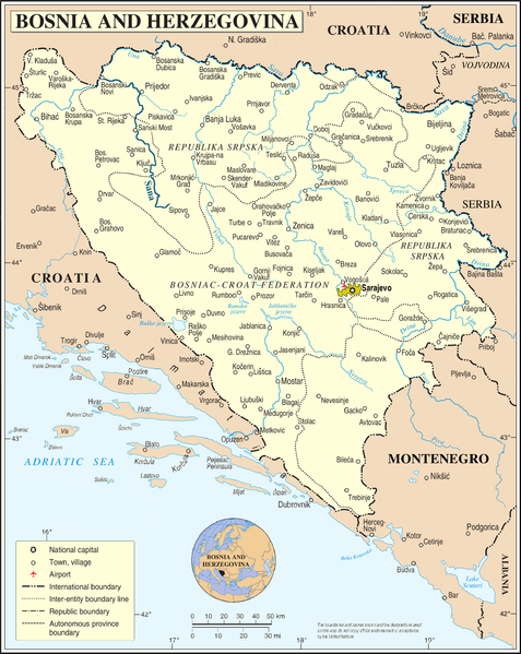
کورتە
| وەسف |
Deutsch: Fluss Sana in Bosnien und Herzegowina (Ortsnamen entsprechen dem Stand von vor 1993)
English: Sana river in Bosnia and Herzegovina (Names of towns as before 1993) |
| ڕێکەوت | 01-03-2009 |
| سەرچاوە |
self-made, using
|
| بەرھەمھێنەر | NordNordWest |

|
This map has been made or improved in the German Kartenwerkstatt (Map Lab). You can propose maps to improve as well.
|
مۆڵەتنامە
| من، هەڵگری مافی لەبەرگرتنەوەی ئەم بەرھەمە، ئەم بەرھەمە بڵاودەکەمەوە بۆ پاوانی گشتی (public domain). ئەم مافە بۆ سەرانسەری جیھانە. لە ھەندێ وڵاتدا لەوانەیە یاسا، ڕێگە بەمە نەدات؛ لەو کاتەدا: من مافی بەکارھێنانی ئەم بەرھەمە بۆ ھەر مەبەستێک دەبەخشم بە ھەموو کەسێک، بێ ھیچ مەرجێک، مەگەر ئەو چەشنە مەرجانە کە یاسا ھەبوونیانی بە پێویستی بزانێت. |
مێژووی پەڕگە
کرتە بکە لەسەر یەکێک لە ڕێکەوت/کاتەکان بۆ بینینی پەڕگەکە بەو شێوەی لەو کاتەدا بووە.
| ڕێکەوت/کات | ھێما | ئەندازە | بەکارھێنەر | تێبینی | |
|---|---|---|---|---|---|
| هەنووکە | ١٩:٤٧، ٢ی ئازاری ٢٠٠٩ | | ٢٬٣٤٨ لە ٢٬٩٤٨ (١٫٦٥ مێگابایت) | Mazbln | "Titov" at Drvar removed |
| ٢٣:٣١، ٢٨ی شوباتی ٢٠٠٩ |  | ٢٬٣٤٨ لە ٢٬٩٤٨ (١٫١٦ مێگابایت) | NordNordWest | {{Information |Description={{de|Fluss Sana in Bosnien und Herzegowina}} {{en|Sana river in Bosnia and Herzegovina}} |Source=self-made, using * file:Bosnia and Hercegovina map.png by The Cartographic Section of |
بەکارھێنانی پەڕگە
ئەم پەڕەیە ئەم پەڕگەیە بەکار دەھێنێت:
بەکارھێنانی سەرانسەریی پەڕگە
ئەم ویکیانەی دیکەی خوارەوەش ئەم پەڕگە بەکاردێنن:
- بەکارھێنان لە ca.wikipedia.org
- بەکارھێنان لە de.wikipedia.org
- بەکارھێنان لە en.wikipedia.org
- بەکارھێنان لە fa.wikipedia.org
- بەکارھێنان لە hu.wikipedia.org
- بەکارھێنان لە id.wikipedia.org
- بەکارھێنان لە it.wikipedia.org
- بەکارھێنان لە mzn.wikipedia.org
- بەکارھێنان لە www.wikidata.org