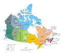
پەڕگە:Political map of Canada ar.png

Political_map_of_Canada_ar.png(٦٩٣ × ٥٩٩ پیکسڵ، قەبارەی پەڕگە: ١٤٧ کیلۆبایت، جۆری ئێم ئای ئێم ئی: image/png)

ئەم پەڕگە لە Wikimedia Commonsەوەیە و لەوانەیە لە پڕۆژەکانی دیکەش بەکار ھاتبێت. پێناسەکەی لەسەر پەڕەی وەسفی پەڕگەکە لە خوارەوە نیشان دراوە.

وەسف
English: A map of Canada exhibiting its ten provinces and three territories, and their capitals. (Lambert conformal conic projection from The Atlas of Canada)
ڕێکەوت (UTC)
سەرچاوە
بەرھەمھێنەر
This is a retouched picture, which means that it has been digitally altered from its original version. Modifications: translated to arabic. The original can be viewed here: Political map of Canada.png. Modifications made by Bassem.

من، ھەڵگری مافی لەبەرگرتنەوەی ئەم بەرھەمە، لەژێر ئەم مۆڵەتنامەیەدا بڵاوی دەکەمەوە:
ئەم بەرھەمە بەدەستی بەرھەمھێنەرەکەی Example, at the [[::|ئینگلیزی ویکیپیدیا]] project، بڵاوکراوەتەوە بۆ پاوانی گشتی (public domain). ئەم مافە بۆ سەرانسەری جیھانە.

In case this is not legally possible:
Example مافی بەکارھێنانی ئەم بەرھەمە بۆ ھەر مەبەستێک دەبەخشێ بە ھەموو کەسێک، بێ ھیچ مەرجێک، مەگەر ئەو چەشنە مەرجانە کە یاسا ھەبوونیانی بە پێویستی بزانێت.

Original upload log

This image is a derivative work of the following images:

  • File:Political_map_of_Canada.png licensed with PD-user-w
    • 2007-06-13T02:50:40Z Andrew pmk 1280x1107 (250520 Bytes) optimize png
    • 2007-06-06T01:38:46Z Andrew pmk 1280x1107 (250520 Bytes) optimize png
    • 2006-06-06T09:35:23Z Kaveh 1280x1107 (302665 Bytes) == Summary == [[Canada]]: political map – depicting |provinces/territories and capital cities. Drawn and adapted by [[:en:User:E Pluribus Anthony|E Pluribus Anthony]] from [http://atlas.gc.ca/site/english/maps/reference/n

Uploaded with derivativeFX

Annotations
InfoField
This image is annotated: View the annotations at Commons

لێدوانەکان

Add a one-line explanation of what this file represents

بەندەکانی لەم پەڕگەیەدا دەردەکەون

depicts ئینگلیزی

MIME type ئینگلیزی

image/png

مێژووی پەڕگە

کرتە بکە لەسەر یەکێک لە ڕێکەوت/کاتەکان بۆ بینینی پەڕگەکە بەو شێوەی لەو کاتەدا بووە.

ڕێکەوت/کاتھێمائەندازەبەکارھێنەرتێبینی
هەنووکە‏١٥:٥٤، ١٩ی کانوونی دووەمی ٢٠١١ھێما بۆ وەشانی  ‏١٥:٥٤، ١٩ی کانوونی دووەمی ٢٠١١٦٩٣ لە ٥٩٩ (١٤٧ کیلۆبایت)باسمGrammatical correction
‏١٥:٥١، ١٩ی کانوونی دووەمی ٢٠١١ھێما بۆ وەشانی  ‏١٥:٥١، ١٩ی کانوونی دووەمی ٢٠١١٦٩٣ لە ٥٩٩ (١٤٧ کیلۆبایت)باسمGrammatical correction
‏١٥:٢١، ١٩ی کانوونی دووەمی ٢٠١١ھێما بۆ وەشانی  ‏١٥:٢١، ١٩ی کانوونی دووەمی ٢٠١١٦٩٣ لە ٥٩٩ (١٤٧ کیلۆبایت)باسمGrammatical corrections
‏١٦:٠٥، ٢ی کانوونی یەکەمی ٢٠١٠ھێما بۆ وەشانی  ‏١٦:٠٥، ٢ی کانوونی یەکەمی ٢٠١٠٦٩٣ لە ٥٩٩ (١٤٨ کیلۆبایت)باسم{{Information |Description={{en|1=A map of Canada exhibiting its ten provinces and three territories, and their capitals. (Lambert conformal conic projection from [http://atlas.gc.ca/site/english/maps/reference/national/can_political_e The Atlas of Canada

ئەم پەڕەیە ئەم پەڕگەیە بەکار دەھێنێت:

بەکارھێنانی سەرانسەریی پەڕگە

ئەم ویکیانەی دیکەی خوارەوەش ئەم پەڕگە بەکاردێنن: