پەڕگە:Ottoman Empire 1914 h.PNG

قەبارەی ئەم پێشبینینە: ٥١٨ لە ٦٠٠ پیکسەڵ. ڕێزەلووشنەکانی تر: ٢٠٧ لە ٢٤٠ پیکسەڵ | ٤١٥ لە ٤٨٠ پیکسەڵ | ٦٤٠ لە ٧٤١ پیکسەڵ.
پەڕگەی سەرەکی (٦٤٠ × ٧٤١ پیکسڵ، قەبارەی پەڕگە: ٢٧ کیلۆبایت، جۆری ئێم ئای ئێم ئی: image/png)
کورتە
| وەسف |
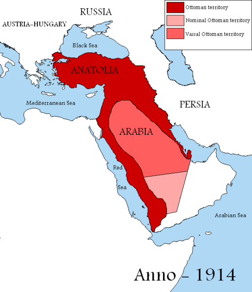
English: Map showing the territories of the Ottoman Empire in 1914, including nominal and vassal territories.
According to the information on the map in http://ottomanmilitary.devhub.com/ |
| ڕێکەوت | |
| سەرچاوە | بەرھەمی خۆم |
| بەرھەمھێنەر | DragonTiger23 |
| وەشانەکانی تر |
[]
|


Many people actually lived in this empire from time to time
مۆڵەتنامە
| من، هەڵگری مافی لەبەرگرتنەوەی ئەم بەرھەمە، ئەم بەرھەمە بڵاودەکەمەوە بۆ پاوانی گشتی (public domain). ئەم مافە بۆ سەرانسەری جیھانە. لە ھەندێ وڵاتدا لەوانەیە یاسا، ڕێگە بەمە نەدات؛ لەو کاتەدا: من مافی بەکارھێنانی ئەم بەرھەمە بۆ ھەر مەبەستێک دەبەخشم بە ھەموو کەسێک، بێ ھیچ مەرجێک، مەگەر ئەو چەشنە مەرجانە کە یاسا ھەبوونیانی بە پێویستی بزانێت. |

|
This historical map image could be re-created using vector graphics as an SVG file. This has several advantages; see Commons:Media for cleanup for more information. If an SVG form of this image is available, please upload it and afterwards replace this template with
{{vector version available|new image name}}.
It is recommended to name the SVG file “Ottoman Empire 1914 h.svg”—then the template Vector version available (or Vva) does not need the new image name parameter. |
مێژووی پەڕگە
کرتە بکە لەسەر یەکێک لە ڕێکەوت/کاتەکان بۆ بینینی پەڕگەکە بەو شێوەی لەو کاتەدا بووە.
| ڕێکەوت/کات | ھێما | ئەندازە | بەکارھێنەر | تێبینی | |
|---|---|---|---|---|---|
| هەنووکە | ١٣:٠٤، ٢٩ی ئابی ٢٠١٩ | | ٦٤٠ لە ٧٤١ (٢٧ کیلۆبایت) | Aybeg | Cyprus was under British control. |
| ١٤:٢٠، ٢٨ی ئابی ٢٠١٩ |  | ٦٤٠ لە ٧٤١ (٢٧ کیلۆبایت) | Aybeg | In 1914, the Ottomans did not rule over Egypt and Sudan. | |
| ١٣:٠٣، ١٣ی کانوونی دووەمی ٢٠١١ |  | ٦٤٠ لە ٧٤١ (٣٣ کیلۆبایت) | DragonTiger23 | {{Information |Description={{en|1=Map showing the territories of the Ottoman Empire in 1914, including nominal and vassal territories. According to the information on the map in http://ottomanmilitary.devhub.com/}} |Source={{own}} |Author=[[User:DragonTi |
بەکارھێنانی پەڕگە
ھیچ پەڕەیەک نییە کە ئەم پەڕگەیە بەکاربھێنێت.
بەکارھێنانی سەرانسەریی پەڕگە
ئەم ویکیانەی دیکەی خوارەوەش ئەم پەڕگە بەکاردێنن:
- بەکارھێنان لە ar.wikipedia.org
- بەکارھێنان لە be.wikipedia.org
- بەکارھێنان لە bg.wikipedia.org
- بەکارھێنان لە en.wikipedia.org
- بەکارھێنان لە fr.wikipedia.org
- بەکارھێنان لە he.wikipedia.org
- بەکارھێنان لە hu.wikipedia.org
- بەکارھێنان لە it.wikipedia.org
- بەکارھێنان لە nl.wikipedia.org
- بەکارھێنان لە pt.wikipedia.org