پەڕگە:Ortelius - Maris Pacifici 1589.jpg

قەبارەی ئەم پێشبینینە: ٨٠٠ لە ٥٥٤ پیکسەڵ. ڕێزەلووشنەکانی تر: ٣٢٠ لە ٢٢٢ پیکسەڵ | ٦٤٠ لە ٤٤٣ پیکسەڵ | ١٬٠٢٤ لە ٧٠٩ پیکسەڵ | ١٬٢٨٠ لە ٨٨٦ پیکسەڵ | ٢٬٥٦٠ لە ١٬٧٧٣ پیکسەڵ | ٤٬٠٠١ لە ٢٬٧٧١ پیکسەڵ.
پەڕگەی سەرەکی (٤٬٠٠١ × ٢٬٧٧١ پیکسڵ، قەبارەی پەڕگە: ٣٫٨١ مێگابایت، جۆری ئێم ئای ئێم ئی: image/jpeg)
|
کورتە
| وەسف |
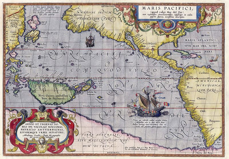
English: Maris Pacifici by Abraham Ortelius. This map was published in 1589 in his Theatrum Orbis Terrarum. It was not only the first printed map of the Pacific, but it also showed the Americas for the first time. Español: Maris Pacifici de Abraham Ortelius. Este mapa fue publicado en 1589 en su Theatrum Orbis Terrarum. No solo fue el primer mapa impreso del Pacífico, sino que también mostró las Américas por primera vez. Bajo la ilustración de la nao Victoria cruzando el Pacífico puede leer lo siguiente en latín: «Prima ego velivovis ambivi cursibus Orbem, Magellane novo te duce ducta freto. Ambivi, meritoque vocor VICTORIA: sunt mî Vela, alæ; precium, gloria: pugna mare» (en español, «Fui la primera en navegar alrededor del mundo por medio de velas, y te llevé a ti, Magallanes, líder, primero a través del estrecho. Navegué alrededor del mundo, por lo tanto, justamente me llamo Victoria, mis velas eran mis alas, mi premio era la gloria, mi lucha era con el mar»). |
|||||||||||||||||||||||
| ڕێکەوت | ||||||||||||||||||||||||
| سەرچاوە | Helmink Antique Maps | |||||||||||||||||||||||
| بەرھەمھێنەر |
|
|||||||||||||||||||||||
| ڕێپێدان (بەکارھێنانەوەی ئەم پەڕگەیە) |
|
|||||||||||||||||||||||
| وەشانەکانی تر |
|
|||||||||||||||||||||||


مێژووی پەڕگە
کرتە بکە لەسەر یەکێک لە ڕێکەوت/کاتەکان بۆ بینینی پەڕگەکە بەو شێوەی لەو کاتەدا بووە.
| ڕێکەوت/کات | ھێما | ئەندازە | بەکارھێنەر | تێبینی | |
|---|---|---|---|---|---|
| هەنووکە | ١٥:٥٠، ٥ی ئایاری ٢٠٠٧ | | ٤٬٠٠١ لە ٢٬٧٧١ (٣٫٨١ مێگابایت) | Jan Arkesteijn | {{Information |Description=Maris Pacifici by Abraham Ortelius |Source=[http://www.helmink.com/Antique_Map_Ortelius_Pacific/ Helmink Antique Maps] |Date=1589 |Author=Abraham Ortelius }} This map was published in 1589 in his 'Theatrum Orbis Terrarum'. It w |
بەکارھێنانی پەڕگە
ئەم پەڕەیە ئەم پەڕگەیە بەکار دەھێنێت:
بەکارھێنانی سەرانسەریی پەڕگە
ئەم ویکیانەی دیکەی خوارەوەش ئەم پەڕگە بەکاردێنن:
- بەکارھێنان لە als.wikipedia.org
- بەکارھێنان لە ar.wikipedia.org
- بەکارھێنان لە azb.wikipedia.org
- بەکارھێنان لە az.wikipedia.org
- بەکارھێنان لە bcl.wikipedia.org
- بەکارھێنان لە be.wikipedia.org
- بەکارھێنان لە bn.wikipedia.org
- بەکارھێنان لە bo.wikipedia.org
- بەکارھێنان لە ca.wikipedia.org
- بەکارھێنان لە da.wikipedia.org
- بەکارھێنان لە de.wikipedia.org
- بەکارھێنان لە en.wikipedia.org
- Pacific Ocean
- Abraham Ortelius
- Theatrum Orbis Terrarum
- Portal:Maps/Selected picture
- Wikipedia:Featured pictures thumbs/11
- Wikipedia:Featured picture candidates/March-2008
- Wikipedia:Featured picture candidates/File:Ortelius - Maris Pacifici 1589.jpg
- Wikipedia:Wikipedia Signpost/2008-03-31/Features and admins
- Wikipedia:Featured pictures/Diagrams, drawings, and maps/Maps
- Maris Pacifici
- User talk:Paulcmnt/Archive 1
- Wikipedia:Wikipedia Signpost/2008-03-31/SPV
- Wikipedia:Picture of the day/October 2008
- Template:POTD/2008-10-23
- Portal:Maps/Selected picture/50
- Wikipedia:Graphics Lab/Photography workshop/Archive/Jul 2010
- Portal:Oceans
- Wikipedia:Contents/gallery2
- Wikipedia:Wikipedia Signpost/Single/2008-03-31
- بەکارھێنان لە es.wikipedia.org
- بەکارھێنان لە fr.wikipedia.org
- بەکارھێنان لە fr.wikiversity.org
- بەکارھێنان لە fy.wikipedia.org
- بەکارھێنان لە gcr.wikipedia.org
- بەکارھێنان لە gl.wikipedia.org
- بەکارھێنان لە he.wikipedia.org
- بەکارھێنان لە hi.wikipedia.org
- بەکارھێنان لە hu.wikipedia.org
- بەکارھێنان لە hy.wikipedia.org
بینینی بەکارھێنانی گشتی زیاتری ئەم پەڕگەیە.