پەڕگە:IBCAO betamap.jpg
قەبارەی ئەم پێشبینینە: ٥٢٦ لە ٥٩٩ پیکسەڵ. ڕێزەلووشنەکانی تر: ٢١١ لە ٢٤٠ پیکسەڵ | ٤٢١ لە ٤٨٠ پیکسەڵ | ٧٦٢ لە ٨٦٨ پیکسەڵ.
پەڕگەی سەرەکی (٧٦٢ × ٨٦٨ پیکسڵ، قەبارەی پەڕگە: ٧١٠ کیلۆبایت، جۆری ئێم ئای ئێم ئی: image/jpeg)
| Description |
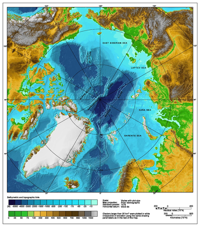
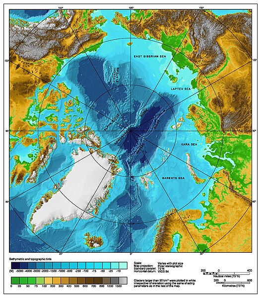
Bathymetric map of the Arctic Ocean |
|||||||||
| سەرچاوە | http://www.ngdc.noaa.gov/mgg/image/IBCAO_betamap.jpg | |||||||||
| ڕێپێدان (بەکارھێنانەوەی ئەم پەڕگەیە) |
|
|||||||||
| Geotemporal data | ||||||||||
| Bounding box |
|
|||||||||
| Georeferencing | ||||||||||
| وەشانەکانی تر |
Derivative works of this file: |
|||||||||
مێژووی پەڕگە
کرتە بکە لەسەر یەکێک لە ڕێکەوت/کاتەکان بۆ بینینی پەڕگەکە بەو شێوەی لەو کاتەدا بووە.
| ڕێکەوت/کات | ھێما | ئەندازە | بەکارھێنەر | تێبینی | |
|---|---|---|---|---|---|
| هەنووکە | ٠٠:٢٩، ٢ی ئابی ٢٠٠٧ | | ٧٦٢ لە ٨٦٨ (٧١٠ کیلۆبایت) | Mikkalai | Source: http://www.ngdc.noaa.gov/mgg/image/IBCAO_betamap.jpg Bathymetric map of the w:Arctic Ocean |
بەکارھێنانی پەڕگە
ھیچ پەڕەیەک نییە کە ئەم پەڕگەیە بەکاربھێنێت.
بەکارھێنانی سەرانسەریی پەڕگە
ئەم ویکیانەی دیکەی خوارەوەش ئەم پەڕگە بەکاردێنن:
- بەکارھێنان لە af.wikipedia.org
- بەکارھێنان لە ar.wikipedia.org
- بەکارھێنان لە ary.wikipedia.org
- بەکارھێنان لە ast.wikipedia.org
- بەکارھێنان لە avk.wikipedia.org
- بەکارھێنان لە azb.wikipedia.org
- بەکارھێنان لە bcl.wikipedia.org
- بەکارھێنان لە be.wikipedia.org
- بەکارھێنان لە bg.wikipedia.org
- بەکارھێنان لە bh.wikipedia.org
- بەکارھێنان لە bn.wikipedia.org
- بەکارھێنان لە bxr.wikipedia.org
- بەکارھێنان لە ca.wikipedia.org
- بەکارھێنان لە ceb.wikipedia.org
- بەکارھێنان لە chr.wikipedia.org
- بەکارھێنان لە co.wikipedia.org
- بەکارھێنان لە crh.wikipedia.org
- بەکارھێنان لە cs.wikipedia.org
- بەکارھێنان لە da.wikipedia.org
- بەکارھێنان لە de.wikipedia.org
- بەکارھێنان لە dty.wikipedia.org
- بەکارھێنان لە en.wikipedia.org
- Talk:Lomonosov Ridge
- Territorial claims in the Arctic
- Arktika 2007
- Portal:Maps/Maps/Geographic
- Portal:Maps/Maps/Geographic/2
- Arctic Ocean
- User:Wiki User 68/My Portal
- User:Wiki User 68/My Portal/Selected geography/1
- List of Russian explorers
- Wikipedia:Reference desk/Archives/Science/2015 May 29
- User:Joelton Ivson/Gather lists/24441 – Conflitos internacionais
- Portal:Oceans
- بەکارھێنان لە en.wikinews.org
- بەکارھێنان لە en.wikiversity.org
- بەکارھێنان لە eo.wikipedia.org
- بەکارھێنان لە es.wikipedia.org
بینینی بەکارھێنانی گشتی زیاتری ئەم پەڕگەیە.