پەڕگە:Global Temperature Anomaly 1880-2010 (Fig.A).gif
رەزۆلوشنی سەرتر لەمە لە بەردەست دا نیە.
Global_Temperature_Anomaly_1880-2010_(Fig.A).gif (٦٥٨ × ٤٧٤ پیکسڵ، قەبارەی پەڕگە: ٣٠ کیلۆبایت، جۆری ئێم ئای ئێم ئی: image/gif)
کورتە
| وەسف |
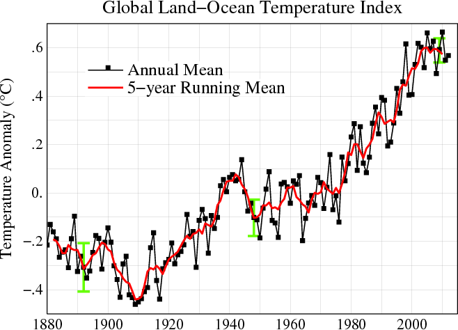
English: Line plot of global mean land-ocean temperature index, 1880 to present, with the base period 1951-1980. The black line is the annual mean and the red line is the five-year running mean. The green bars show uncertainty estimates. [This is an update of Fig. 1A in Hansen et al. (2006).] The graph shows an overall long-term warming trend. |
|||||
| ڕێکەوت | ||||||
| سەرچاوە | http://data.giss.nasa.gov/gistemp/ | |||||
| بەرھەمھێنەر | NASA Goddard Institute for Space Studies | |||||
| ڕێپێدان (بەکارھێنانەوەی ئەم پەڕگەیە) |
|
|||||
| وەشانەکانی تر |
PDF version: File:Global_Temperature_Anomaly_1880-2010_(Fig.A).pdf. SVG version (1880-2010 data, 1961-1990 base period): File:Instrumental Temperature Record (NASA).svg
|

.gif)
.svg)

|
File:Global Temperature Anomaly.svg is a vector version of this file. It should be used in place of this GIF file when not inferior.
File:Global Temperature Anomaly 1880-2010 (Fig.A).gif → File:Global Temperature Anomaly.svg
For more information, see Help:SVG. |
 |
مێژووی پەڕگە
کرتە بکە لەسەر یەکێک لە ڕێکەوت/کاتەکان بۆ بینینی پەڕگەکە بەو شێوەی لەو کاتەدا بووە.
| ڕێکەوت/کات | ھێما | ئەندازە | بەکارھێنەر | تێبینی | |
|---|---|---|---|---|---|
| هەنووکە | ١٥:٥٦، ٢١ی حوزەیرانی ٢٠١٣ | | ٦٥٨ لە ٤٧٤ (٣٠ کیلۆبایت) | Nigelj | Upload version that has been updated with 2012 data |
| ٢١:٢٠، ١٩ی کانوونی دووەمی ٢٠١٢ |  | ٦٥٢ لە ٤٧٤ (٣١ کیلۆبایت) | Simplex1swrhs | I have uploaded a new version of the NASA global temperature graph with 2011 data. | |
| ١٥:٥٨، ١٩ی ئازاری ٢٠١١ |  | ٦٥٢ لە ٤٧٤ (٣١ کیلۆبایت) | Simplex1swrhs | Switched back to the NASA GISS "Global Land-Ocean Temperature Index" graph with 2010 data update. {{Information |Description= Line plot of global mean land-ocean temperature index, 1880 to present, with the base period 1951-1980. The dotted black line is | |
| ٢٠:٠٥، ٣ی ئازاری ٢٠١١ |  | ٦٥٥ لە ٤٣٩ (٣٠ کیلۆبایت) | OKIsItJustMe | {{Information |Description ={{en|1=Line plot of global mean land-ocean temperature index, 1880 to present, with the base period 1951-1980. The dotted black line is the annual mean and the solid red line is the five-year mean. The green bars show uncert |
بەکارھێنانی پەڕگە
ھیچ پەڕەیەک نییە کە ئەم پەڕگەیە بەکاربھێنێت.
بەکارھێنانی سەرانسەریی پەڕگە
ئەم ویکیانەی دیکەی خوارەوەش ئەم پەڕگە بەکاردێنن:
- بەکارھێنان لە ar.wikipedia.org
- بەکارھێنان لە en.wikipedia.org
- بەکارھێنان لە fr.wikipedia.org
- بەکارھێنان لە ko.wikipedia.org
- بەکارھێنان لە no.wikipedia.org
- بەکارھێنان لە vi.wikipedia.org
- بەکارھێنان لە zh.wikipedia.org
.gif)