پەڕگە:Fixed gulf map.png
رەزۆلوشنی سەرتر لەمە لە بەردەست دا نیە.
Fixed_gulf_map.png (٧٣٤ × ٦٠٠ پیکسڵ، قەبارەی پەڕگە: ١٬٠٠١ کیلۆبایت، جۆری ئێم ئای ئێم ئی: image/png)
کورتە
| وەسف |
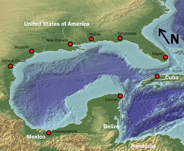
English: "The Gulf of Mexico in 3D perspective. A GIS can create very accurate and realistic-looking environments." |
| سەرچاوە | Source (High-Res: 3000x2451) |
| بەرھەمھێنەر | NOAA |
| ڕێپێدان (بەکارھێنانەوەی ئەم پەڕگەیە) |
Public domain |
| وەشانەکانی تر |
 |
مۆڵەتنامە
This image is in the public domain because it contains materials that originally came from the U.S. National Oceanic and Atmospheric Administration, taken or made as part of an employee's official duties.
|
مێژووی پەڕگە
کرتە بکە لەسەر یەکێک لە ڕێکەوت/کاتەکان بۆ بینینی پەڕگەکە بەو شێوەی لەو کاتەدا بووە.
| ڕێکەوت/کات | ھێما | ئەندازە | بەکارھێنەر | تێبینی | |
|---|---|---|---|---|---|
| هەنووکە | ٠٤:٠٧، ٤ی ئایاری ٢٠١٠ | | ٧٣٤ لە ٦٠٠ (١٬٠٠١ کیلۆبایت) | GatorSlayerFSU | {{Information |Description={{en|1=Fixed the gap in pic}} |Source=Public Domain |Author=GatorSlayerFSU |Date=5/4/10 |Permission= |other_versions= }} |
بەکارھێنانی پەڕگە
ئەم پەڕەیە ئەم پەڕگەیە بەکار دەھێنێت:
بەکارھێنانی سەرانسەریی پەڕگە
ئەم ویکیانەی دیکەی خوارەوەش ئەم پەڕگە بەکاردێنن:
- بەکارھێنان لە arc.wikipedia.org
- بەکارھێنان لە azb.wikipedia.org
- بەکارھێنان لە az.wikipedia.org
- بەکارھێنان لە bg.wikipedia.org
- بەکارھێنان لە bn.wikipedia.org
- بەکارھێنان لە cs.wikipedia.org
- بەکارھێنان لە de.wikipedia.org
- بەکارھێنان لە en.wikipedia.org
- بەکارھێنان لە fa.wikipedia.org
- بەکارھێنان لە fi.wiktionary.org
- بەکارھێنان لە fo.wikipedia.org
- بەکارھێنان لە fr.wikipedia.org
- بەکارھێنان لە fy.wikipedia.org
- بەکارھێنان لە gl.wikipedia.org
- بەکارھێنان لە hak.wikipedia.org
- بەکارھێنان لە he.wikipedia.org
- بەکارھێنان لە hi.wikipedia.org
- بەکارھێنان لە hr.wikipedia.org
- بەکارھێنان لە ilo.wikipedia.org
- بەکارھێنان لە is.wikipedia.org
- بەکارھێنان لە ka.wikipedia.org
- بەکارھێنان لە lb.wikipedia.org
- بەکارھێنان لە lfn.wikipedia.org
- بەکارھێنان لە mk.wikipedia.org
- بەکارھێنان لە ml.wikipedia.org
- بەکارھێنان لە mn.wikipedia.org
- بەکارھێنان لە mr.wikipedia.org
- بەکارھێنان لە ms.wikipedia.org
- بەکارھێنان لە ne.wikipedia.org
- بەکارھێنان لە pa.wikipedia.org
- بەکارھێنان لە ru.wikipedia.org
- بەکارھێنان لە sco.wikipedia.org
- بەکارھێنان لە sq.wikipedia.org
- بەکارھێنان لە sr.wikipedia.org
- بەکارھێنان لە ta.wikipedia.org
- بەکارھێنان لە tl.wikipedia.org
- بەکارھێنان لە vi.wikipedia.org
- بەکارھێنان لە www.wikidata.org
- بەکارھێنان لە zh.wikipedia.org