پەڕگە:Division of Gaul - 587.jpg
پەڕگەی سەرەکی (١٬٢٣٥ × ١٬١٥٣ پیکسڵ، قەبارەی پەڕگە: ٣٥٧ کیلۆبایت، جۆری ئێم ئای ئێم ئی: image/jpeg)
کورتە
| وەسف |
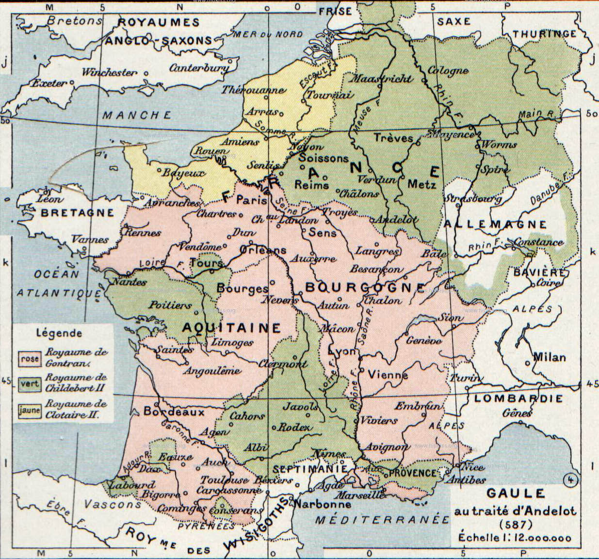
English: The map comes from Vidal-Lablache, Atlas général d'histoire et de géographie (1894). It shows Gaul in 587 AD.
Français : Gaule au traité d'Andelot (587). Paul Vidal de La Blache, Atlas général d'histoire et de géographie (1894).
Русский: Карта владений Меровингов из книги. |
||||||||||||||||||||
| ڕێکەوت | |||||||||||||||||||||
| سەرچاوە | Paul Vidal de La Blache, Atlas général d'histoire et de géographie (1894). | ||||||||||||||||||||
| بەرھەمھێنەر |
|
||||||||||||||||||||
| وەشانەکانی تر | |||||||||||||||||||||

.jpg)
مۆڵەتنامە
This image is in the public domain because it is a mere mechanical scan or photocopy of a public domain original, or – from the available evidence – is so similar to such a scan or photocopy that no copyright protection can be expected to arise. The original itself is in the public domain for the following reason:
This tag is designed for use where there may be a need to assert that any enhancements (eg brightness, contrast, colour-matching, sharpening) are in themselves insufficiently creative to generate a new copyright. It can be used where it is unknown whether any enhancements have been made, as well as when the enhancements are clear but insufficient. For known raw unenhanced scans you can use an appropriate {{PD-old}} tag instead. For usage, see Commons:When to use the PD-scan tag.  | ||||
Original upload log
- 2007-08-19 21:29 Srnec 1235×1153×8 (365416 bytes) The map comes from Vidal-Lablache, ''Atlas général d'histoire et de géographie'' (1894). {{PD-art-life-70}}
مێژووی پەڕگە
کرتە بکە لەسەر یەکێک لە ڕێکەوت/کاتەکان بۆ بینینی پەڕگەکە بەو شێوەی لەو کاتەدا بووە.
| ڕێکەوت/کات | ھێما | ئەندازە | بەکارھێنەر | تێبینی | |
|---|---|---|---|---|---|
| هەنووکە | ١٣:٠٢، ٣ی کانوونی دووەمی ٢٠٠٨ | | ١٬٢٣٥ لە ١٬١٥٣ (٣٥٧ کیلۆبایت) | Laurens~commonswiki | {{Information |Description={{en|The map comes from Vidal-Lablache, ''Atlas général d'histoire et de géographie'' (1894).}} |Source=Transfered from [http://en.wikipedia.org en.wikipedia] |Date=2007-08-19 (original upload date) |Author=Original uploader |
بەکارھێنانی پەڕگە
ئەم پەڕەیە ئەم پەڕگەیە بەکار دەھێنێت:
بەکارھێنانی سەرانسەریی پەڕگە
ئەم ویکیانەی دیکەی خوارەوەش ئەم پەڕگە بەکاردێنن:
- بەکارھێنان لە af.wikipedia.org
- بەکارھێنان لە ar.wikipedia.org
- بەکارھێنان لە azb.wikipedia.org
- بەکارھێنان لە br.wikipedia.org
- بەکارھێنان لە ca.wikipedia.org
- بەکارھێنان لە cs.wikipedia.org
- بەکارھێنان لە el.wikipedia.org
- بەکارھێنان لە en.wikipedia.org
- بەکارھێنان لە fa.wikipedia.org
- بەکارھێنان لە fr.wikipedia.org
- بەکارھێنان لە gl.wikipedia.org
- بەکارھێنان لە got.wikipedia.org
- بەکارھێنان لە hy.wikipedia.org
- بەکارھێنان لە id.wikipedia.org
- بەکارھێنان لە it.wikipedia.org
- بەکارھێنان لە ja.wikipedia.org
- بەکارھێنان لە la.wikipedia.org
- بەکارھێنان لە mk.wikipedia.org
- بەکارھێنان لە nl.wikipedia.org
- بەکارھێنان لە ro.wikipedia.org
- بەکارھێنان لە ru.wikipedia.org
بینینی بەکارھێنانی گشتی زیاتری ئەم پەڕگەیە.