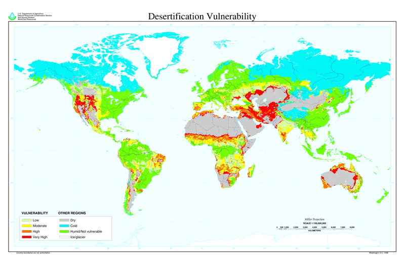
پەڕگە:Desertification map.png

قەبارەی ئەم پێشبینینە: ٨٠٠ لە ٥١٨ پیکسەڵ. ڕێزەلووشنەکانی تر: ٣٢٠ لە ٢٠٧ پیکسەڵ | ٦٤٠ لە ٤١٤ پیکسەڵ | ١٬٠٢٤ لە ٦٦٣ پیکسەڵ | ١٬٢٨٠ لە ٨٢٨ پیکسەڵ | ٢٬٥٦٠ لە ١٬٦٥٦ پیکسەڵ | ٦٬٨٠٠ لە ٤٬٤٠٠ پیکسەڵ.
پەڕگەی سەرەکی (٦٬٨٠٠ × ٤٬٤٠٠ پیکسڵ، قەبارەی پەڕگە: ١٫٠٤ مێگابایت، جۆری ئێم ئای ئێم ئی: image/png)
مێژووی پەڕگە
کرتە بکە لەسەر یەکێک لە ڕێکەوت/کاتەکان بۆ بینینی پەڕگەکە بەو شێوەی لەو کاتەدا بووە.
| ڕێکەوت/کات | ھێما | ئەندازە | بەکارھێنەر | تێبینی | |
|---|---|---|---|---|---|
| هەنووکە | ١١:٠١، ٢٧ی ئازاری ٢٠٢٢ |  | ٦٬٨٠٠ لە ٤٬٤٠٠ (١٫٠٤ مێگابایت) | No.cilepogača | Reverted to version as of 00:12, 8 November 2006 (UTC) |
| ٠٥:١١، ٨ی تشرینی دووەمی ٢٠٠٦ |  | ١٬٧٠٠ لە ١٬١٠٠ (٥٥٨ کیلۆبایت) | Paleorthid | {{Information |Description=Global Desertification Vulnerability Map |Source=http://soils.usda.gov/use/worldsoils/mapindex/desert-map.zip |Date=1998 |Author=USDA employee |Permission=This image is a work of a United States Department of Agriculture employe | |
| ٠٠:١٢، ٨ی تشرینی دووەمی ٢٠٠٦ |  | ٦٬٨٠٠ لە ٤٬٤٠٠ (١٫٠٤ مێگابایت) | Paleorthid | {{Information |Description=Global Desertification Vulnerability Map |Source=http://soils.usda.gov/use/worldsoils/mapindex/desert-map.zip |Date=1998 |Author=USDA employee |Permission=This image is a work of a United States Department of Agriculture employe |
بەکارھێنانی پەڕگە
ئەم پەڕەیە ئەم پەڕگەیە بەکار دەھێنێت:
بەکارھێنانی سەرانسەریی پەڕگە
ئەم ویکیانەی دیکەی خوارەوەش ئەم پەڕگە بەکاردێنن:
- بەکارھێنان لە ar.wikipedia.org
- بەکارھێنان لە az.wikipedia.org
- بەکارھێنان لە bg.wikipedia.org
- بەکارھێنان لە bn.wikipedia.org
- بەکارھێنان لە bo.wikipedia.org
- بەکارھێنان لە ca.wikinews.org
- بەکارھێنان لە cs.wikipedia.org
- بەکارھێنان لە da.wikipedia.org
- بەکارھێنان لە de.wikipedia.org
- بەکارھێنان لە de.wiktionary.org
- بەکارھێنان لە el.wikipedia.org
- بەکارھێنان لە en.wikipedia.org
- بەکارھێنان لە eo.wikipedia.org
- بەکارھێنان لە es.wikipedia.org
- بەکارھێنان لە eu.wikipedia.org
- بەکارھێنان لە fa.wikipedia.org
- بەکارھێنان لە fi.wikipedia.org
- بەکارھێنان لە fr.wikipedia.org
- بەکارھێنان لە fr.wikinews.org
- بەکارھێنان لە ga.wikipedia.org
- بەکارھێنان لە he.wikipedia.org
- بەکارھێنان لە hu.wikipedia.org
- بەکارھێنان لە hy.wikipedia.org
- بەکارھێنان لە id.wikipedia.org
- بەکارھێنان لە is.wikipedia.org
- بەکارھێنان لە it.wikipedia.org
- بەکارھێنان لە ja.wikipedia.org
- بەکارھێنان لە ko.wikipedia.org
بینینی بەکارھێنانی گشتی زیاتری ئەم پەڕگەیە.
