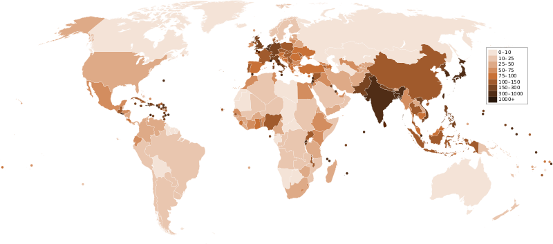
پەڕگە:Countries by population density.svg

Size of this PNG preview of this SVG file: ٨٠٠ لە ٣٥٣ پیکسەڵ. ڕێزەلووشنەکانی تر: ٣٢٠ لە ١٤١ پیکسەڵ | ٦٤٠ لە ٢٨٢ پیکسەڵ | ١٬٠٢٤ لە ٤٥٢ پیکسەڵ | ١٬٢٨٠ لە ٥٦٥ پیکسەڵ | ٢٬٥٦٠ لە ١٬١٢٩ پیکسەڵ | ٦٬٠٠٠ لە ٢٬٦٤٧ پیکسەڵ.
پەڕگەی سەرەکی (پەڕگەی SVG، بە ناو ٦٬٠٠٠ × ٢٬٦٤٧ پیکسەڵ، قەبارەی پەڕگە: ١٫٦٢ مێگابایت)
مێژووی پەڕگە
کرتە بکە لەسەر یەکێک لە ڕێکەوت/کاتەکان بۆ بینینی پەڕگەکە بەو شێوەی لەو کاتەدا بووە.
| ڕێکەوت/کات | ھێما | ئەندازە | بەکارھێنەر | تێبینی | |
|---|---|---|---|---|---|
| هەنووکە | ٢٣:٣٣، ٢١ی کانوونی یەکەمی ٢٠١١ |  | ٦٬٠٠٠ لە ٢٬٦٤٧ (١٫٦٢ مێگابایت) | Quibik | added transparency |
| ١٣:٤٣، ٢٠ی شوباتی ٢٠١١ |  | ٦٬٠٠٠ لە ٢٬٦٤٧ (١٫٦٢ مێگابایت) | Erik del Toro Streb | typographically corrected | |
| ٠٢:٢٢، ٧ی کانوونی دووەمی ٢٠٠٨ |  | ٦٬٠٠٠ لە ٢٬٦٤٧ (١٫٦٢ مێگابایت) | Briefplan~commonswiki | {{Information |Description=A map of the world, with colours to highlight the population density of each country or territory. Numbers on the legend are in people per km<sup>2</sup>, and all countries smaller than 20,000 km<sup>2</sup> are represented by a |
بەکارھێنانی پەڕگە
ئەم پەڕەیە ئەم پەڕگەیە بەکار دەھێنێت:
بەکارھێنانی سەرانسەریی پەڕگە
ئەم ویکیانەی دیکەی خوارەوەش ئەم پەڕگە بەکاردێنن:
- بەکارھێنان لە af.wikipedia.org
- بەکارھێنان لە ar.wikipedia.org
- بەکارھێنان لە arz.wikipedia.org
- بەکارھێنان لە ast.wikipedia.org
- بەکارھێنان لە av.wikipedia.org
- بەکارھێنان لە awa.wikipedia.org
- بەکارھێنان لە azb.wikipedia.org
- بەکارھێنان لە az.wikipedia.org
- بەکارھێنان لە ba.wikipedia.org
- بەکارھێنان لە be.wikipedia.org
- بەکارھێنان لە bg.wikipedia.org
- بەکارھێنان لە bs.wikipedia.org
- بەکارھێنان لە ca.wikipedia.org
- بەکارھێنان لە cs.wikipedia.org
- بەکارھێنان لە cy.wikipedia.org
- بەکارھێنان لە de.wikipedia.org
- بەکارھێنان لە de.wikiversity.org
- بەکارھێنان لە diq.wikipedia.org
- بەکارھێنان لە dsb.wikipedia.org
- بەکارھێنان لە en.wikipedia.org
- بەکارھێنان لە eo.wikipedia.org
- بەکارھێنان لە es.wikipedia.org
- بەکارھێنان لە eu.wikipedia.org
- بەکارھێنان لە fi.wikipedia.org
- بەکارھێنان لە fr.wikipedia.org
- بەکارھێنان لە gl.wikipedia.org
بینینی بەکارھێنانی گشتی زیاتری ئەم پەڕگەیە.