پەڕگە:Carte Topo Region Teheran.png

قەبارەی ئەم پێشبینینە: ٥٦٧ لە ٥٩٩ پیکسەڵ. ڕێزەلووشنەکانی تر: ٢٢٧ لە ٢٤٠ پیکسەڵ | ٤٥٤ لە ٤٨٠ پیکسەڵ | ٧٢٧ لە ٧٦٨ پیکسەڵ | ٩٦٩ لە ١٬٠٢٤ پیکسەڵ | ٢٬١٧٦ لە ٢٬٣٠٠ پیکسەڵ.
پەڕگەی سەرەکی (٢٬١٧٦ × ٢٬٣٠٠ پیکسڵ، قەبارەی پەڕگە: ٣٫٨٩ مێگابایت، جۆری ئێم ئای ئێم ئی: image/png)
کورتە
| وەسف |
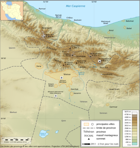
English: Topographic map in French of the Tehran area in Iran.
Note : The shaded relief is a raster image embedded in the SVG file. Français : Carte topographique en français de la région de fr:Téhéran (Iran). Note : Le relief ombré est une image bitmap embarquée dans le fichier SVG. UTM projection ; WGS84 datum ; shaded relief (composite image of N-W, W and N lightning positions) ;
|
| ڕێکەوت | |
| سەرچاوە |
http://www.liranpourlesnuls.net/cartes/carte-teheran-et-sa-region/
|
| بەرھەمھێنەر | Fabien Dany |
| ڕێپێدان (بەکارھێنانەوەی ئەم پەڕگەیە) |
L'utilisation est autorisée selon les termes ci-dessous et à condition de citer comme source : L'Iran pour les nuls www.liranpourlesnuls.net. Un email serait aussi grandement apprécié. |
| وەشانەکانی تر |
 |
| Camera location | | View this and other nearby images on: OpenStreetMap |
|---|
مۆڵەتنامە
ئەم پەڕگەیە لە ژێر مۆڵەتنامەی
Creative Commons Attribution-Share Alike 3.0 Unported دایە.
- تۆ ئازادی:
- بۆ بڵاکردنەوە – بۆ کۆپی کردن، دابەشکردن و دەستبەدەست ناردنی
- بۆ تێکەڵکردنەوە – بۆ سازاندنی کارەکە
- بەم مەرجانەی خوارەوە:
- دانەپاڵ – پێویستە باوەڕی گونجاو بدەیت، بەستەرێک بۆ مۆڵەتەکە دابین بکەیت و ئاماژە بەوە بکەیت کە ئایا گۆڕانکاری کراوە یان نا. دەتوانیت بە هەر شێوەیەکی گونجاو ئەوە بکەیت، بەڵام بە شێوەیەک نا کە وا دەربکەوێت کە مۆڵەتدەر پشتگیری تۆ یان بەکارهێنانەکەت بکات.
- بڵاوکردنەوەی گونجاو – ئەگەر لەسەر بنەمای ئەم کارە تێکەڵ، گۆڕان، یان ساز بکەی، پێویستە بەشدارییەکانت بە هەمان مۆڵەت یان هاوشێوەی مۆڵەتی ئەسڵی دابەش بکەی.
This image has been assessed using the Quality image guidelines and is considered a Quality image.
|
مێژووی پەڕگە
کرتە بکە لەسەر یەکێک لە ڕێکەوت/کاتەکان بۆ بینینی پەڕگەکە بەو شێوەی لەو کاتەدا بووە.
| ڕێکەوت/کات | ھێما | ئەندازە | بەکارھێنەر | تێبینی | |
|---|---|---|---|---|---|
| هەنووکە | ٢٢:١١، ٣٠ی کانوونی دووەمی ٢٠١١ | | ٢٬١٧٦ لە ٢٬٣٠٠ (٣٫٨٩ مێگابایت) | Fabienkhan | {{Information |Description ={{en|1=Topographic map in French of the Tehran area in Iran.<br/>''Note :'' The shaded relief is a raster image embedded in the SVG file.}} {{fr|1=Carte topographique en français de la région de [[:fr:Téhé |
بەکارھێنانی پەڕگە
ئەم پەڕەیە ئەم پەڕگەیە بەکار دەھێنێت:
بەکارھێنانی سەرانسەریی پەڕگە
ئەم ویکیانەی دیکەی خوارەوەش ئەم پەڕگە بەکاردێنن:
- بەکارھێنان لە ar.wikipedia.org
- بەکارھێنان لە cs.wikipedia.org
- بەکارھێنان لە en.wikipedia.org
- بەکارھێنان لە fa.wikipedia.org
- بەکارھێنان لە fr.wikipedia.org
- بەکارھێنان لە incubator.wikimedia.org
- بەکارھێنان لە mg.wikipedia.org
- بەکارھێنان لە my.wikipedia.org
- بەکارھێنان لە vi.wikipedia.org
- بەکارھێنان لە www.wikidata.org