پەڕگە:BlueLine.jpg
قەبارەی ئەم پێشبینینە: ٨٠٠ لە ٥٥٣ پیکسەڵ. ڕێزەلووشنەکانی تر: ٣٢٠ لە ٢٢١ پیکسەڵ | ٦٤٠ لە ٤٤٢ پیکسەڵ | ١٬٠٢٤ لە ٧٠٨ پیکسەڵ | ١٬٢٩٩ لە ٨٩٨ پیکسەڵ.
پەڕگەی سەرەکی (١٬٢٩٩ × ٨٩٨ پیکسڵ، قەبارەی پەڕگە: ١٥٧ کیلۆبایت، جۆری ئێم ئای ئێم ئی: image/jpeg)
کورتە
| وەسف |
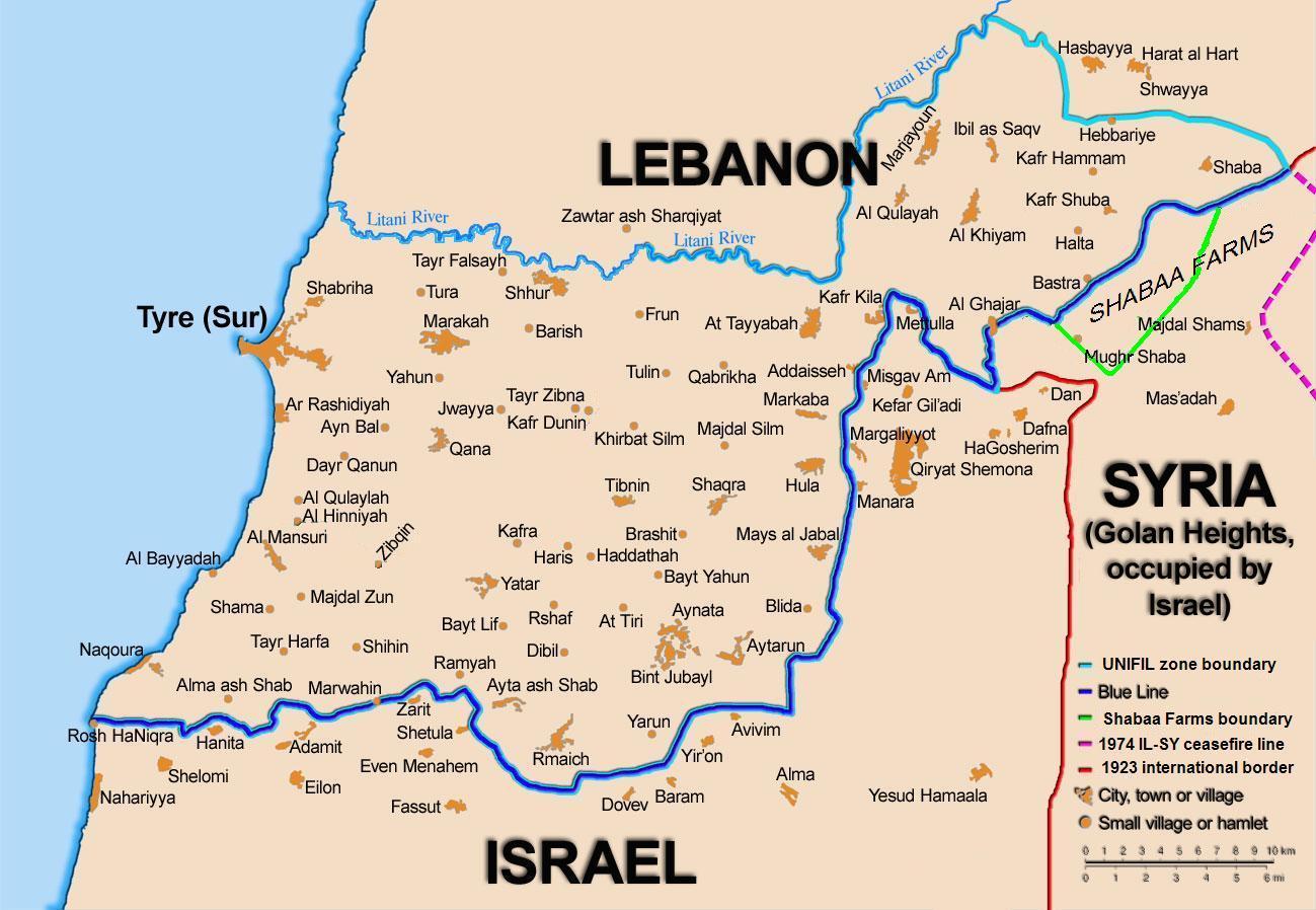
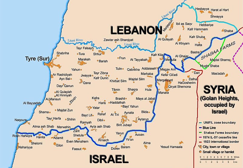
English: Map showing the Blue Line demarcation line between Lebanon and Israel, established by the UN after the Israeli withdrawal from southern Lebanon after its short 1978 invasion called Operation Litani. It follows the 1949 cease-fire line, also known as the Green Line, as well as the somewhat contested Lebanese-Syrian border towards the Israeli-occupied Golan Heights. |
| ڕێکەوت | short 1978 the 1949 July 2006 the 2006 |
| سەرچاوە | Self-published work by 99of9 |
| بەرھەمھێنەر | 99of9 / * The map is made by Thomas Blomberg using the UNIFIL map, deployment as of July 2006 as source. |
| وەشانەکانی تر |
|


|
This map image could be re-created using vector graphics as an SVG file. This has several advantages; see Commons:Media for cleanup for more information. If an SVG form of this image is available, please upload it and afterwards replace this template with
{{vector version available|new image name}}.
It is recommended to name the SVG file “BlueLine.svg”—then the template Vector version available (or Vva) does not need the new image name parameter. |


مۆڵەتنامە
من، ھەڵگری مافی لەبەرگرتنەوەی ئەم بەرھەمە، لەژێر ئەم مۆڵەتنامەیەدا بڵاوی دەکەمەوە:
This file is licensed under the Creative Commons Attribution-Share Alike 2.5 Generic license.
- تۆ ئازادی:
- بۆ بڵاکردنەوە – بۆ کۆپی کردن، دابەشکردن و دەستبەدەست ناردنی
- بۆ تێکەڵکردنەوە – بۆ سازاندنی کارەکە
- بەم مەرجانەی خوارەوە:
- دانەپاڵ – پێویستە باوەڕی گونجاو بدەیت، بەستەرێک بۆ مۆڵەتەکە دابین بکەیت و ئاماژە بەوە بکەیت کە ئایا گۆڕانکاری کراوە یان نا. دەتوانیت بە هەر شێوەیەکی گونجاو ئەوە بکەیت، بەڵام بە شێوەیەک نا کە وا دەربکەوێت کە مۆڵەتدەر پشتگیری تۆ یان بەکارهێنانەکەت بکات.
- بڵاوکردنەوەی گونجاو – ئەگەر لەسەر بنەمای ئەم کارە تێکەڵ، گۆڕان، یان ساز بکەی، پێویستە بەشدارییەکانت بە هەمان مۆڵەت یان هاوشێوەی مۆڵەتی ئەسڵی دابەش بکەی.
مێژووی پەڕگە
کرتە بکە لەسەر یەکێک لە ڕێکەوت/کاتەکان بۆ بینینی پەڕگەکە بەو شێوەی لەو کاتەدا بووە.
| ڕێکەوت/کات | ھێما | ئەندازە | بەکارھێنەر | تێبینی | |
|---|---|---|---|---|---|
| هەنووکە | ١٠:٤٤، ١٦ی تشرینی دووەمی ٢٠١٠ | | ١٬٢٩٩ لە ٨٩٨ (١٥٧ کیلۆبایت) | 99of9 | Reverted to version as of 20:09, 21 October 2010. These boundaries appear to be accepted by both "sides" of the war. Their difference is over the label SYRIA (occupied...) over Golan Heights. For that we are now consistent with the original uploader's |
| ٢٠:٠٩، ٢١ی تشرینی یەکەمی ٢٠١٠ |  | ١٬٢٩٩ لە ٨٩٨ (١٥٧ کیلۆبایت) | Nableezy | keep boundary changes but restore label for syria | |
| ١٦:٣٠، ١٧ی ئابی ٢٠٠٦ |  | ١٬٢٩٩ لە ٨٩٨ (٢٣٨ کیلۆبایت) | Thomas Blomberg | ||
| ١٤:١٦، ٤ی ئابی ٢٠٠٦ |  | ١٬٢٩٩ لە ٨٩٨ (٦٤٣ کیلۆبایت) | Thomas Blomberg | Map showing the Blue Line demarkation line between Lebanon and Israel, established by the UN after the Israeli withdrawal from southern Lebanon after its short 1978 invasion called "Operation Litani". It follows the 1949 cease-fire line, also known as the |
بەکارھێنانی پەڕگە
ئەم پەڕەی 11ە ئەم پەڕگەیە بەکار دەھێنێت:
- بڕیارنامەی ١١٢٢ی ئەنجومەنی ئاسایش
- بڕیارنامەی ١٥٢٥ی ئەنجومەنی ئاسایش
- بڕیارنامەی ١٦٥٥ی ئەنجومەنی ئاسایش
- بڕیارنامەی ٤٢٦ی ئەنجومەنی ئاسایش
- بڕیارنامەی ٤٢٧ی ئەنجومەنی ئاسایش
- بڕیارنامەی ٤٣٤ی ئەنجومەنی ئاسایش
- بڕیارنامەی ٤٤٤ی ئەنجومەنی ئاسایش
- بڕیارنامەی ٥٠١ی ئەنجومەنی ئاسایش
- بڕیارنامەی ٥١١ی ئەنجومەنی ئاسایش
- بڕیارنامەی ٥١٩ی ئەنجومەنی ئاسایش
- بڕیارنامەی ٦٥٩ی ئەنجومەنی ئاسایش
بەکارھێنانی سەرانسەریی پەڕگە
ئەم ویکیانەی دیکەی خوارەوەش ئەم پەڕگە بەکاردێنن:
- بەکارھێنان لە ar.wikipedia.org
- بەکارھێنان لە ast.wikipedia.org
- بەکارھێنان لە azb.wikipedia.org
- بەکارھێنان لە ca.wikipedia.org
- Operació Litani
- Conflicte Israel-Líban
- Història del Líban
- Resolució 262 del Consell de Seguretat de les Nacions Unides
- Resolució 279 del Consell de Seguretat de les Nacions Unides
- Resolució 313 del Consell de Seguretat de les Nacions Unides
- Resolució 317 del Consell de Seguretat de les Nacions Unides
- Resolució 337 del Consell de Seguretat de les Nacions Unides
- Resolució 427 del Consell de Seguretat de les Nacions Unides
- Resolució 425 del Consell de Seguretat de les Nacions Unides
- Resolució 434 del Consell de Seguretat de les Nacions Unides
- Resolució 444 del Consell de Seguretat de les Nacions Unides
- Resolució 501 del Consell de Seguretat de les Nacions Unides
- Resolució 519 del Consell de Seguretat de les Nacions Unides
- Resolució 659 del Consell de Seguretat de les Nacions Unides
- Resolució 938 del Consell de Seguretat de les Nacions Unides
- Resolució 1122 del Consell de Seguretat de les Nacions Unides
- Resolució 1525 del Consell de Seguretat de les Nacions Unides
- Resolució 1655 del Consell de Seguretat de les Nacions Unides
- Resolució 1697 del Consell de Seguretat de les Nacions Unides
- Resolució 1773 del Consell de Seguretat de les Nacions Unides
- بەکارھێنان لە cy.wikipedia.org
- بەکارھێنان لە de.wikipedia.org
- بەکارھێنان لە el.wikipedia.org
- بەکارھێنان لە en.wikipedia.org
- Lebanon
- Shebaa Farms
- Lebanese Civil War
- United Nations Security Council Resolution 425
- 1978 South Lebanon conflict
- Talk:List of ongoing armed conflicts
- Israeli–Lebanese conflict
- South Lebanon conflict (1985–2000)
- History of Hezbollah
- Borders of Israel
- User:Surgam/Hezbollah
- Edward Said
- United Nations Security Council Resolution 426
- United Nations Security Council Resolution 427
- United Nations Security Council Resolution 434
- United Nations Security Council Resolution 444
- United Nations Security Council Resolution 501
- United Nations Security Council Resolution 511
بینینی بەکارھێنانی گشتی زیاتری ئەم پەڕگەیە.