پەڕگە:Arabian Peninsula dust SeaWiFS-2.jpg

قەبارەی ئەم پێشبینینە: ٦٥٧ لە ٦٠٠ پیکسەڵ. ڕێزەلووشنەکانی تر: ٢٦٣ لە ٢٤٠ پیکسەڵ | ٥٢٦ لە ٤٨٠ پیکسەڵ | ٨٤١ لە ٧٦٨ پیکسەڵ | ١٬١٢٢ لە ١٬٠٢٤ پیکسەڵ | ٢٬٥٠٤ لە ٢٬٢٨٦ پیکسەڵ.
پەڕگەی سەرەکی (٢٬٥٠٤ × ٢٬٢٨٦ پیکسڵ، قەبارەی پەڕگە: ٨٦٧ کیلۆبایت، جۆری ئێم ئای ئێم ئی: image/jpeg)
| وەسف |
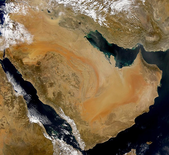
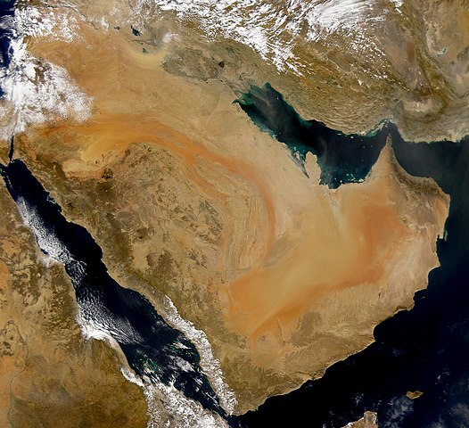
English: SeaWiFS collected this view of the Arabian Peninsula and of dust blowing across the Persian Gulf. Español: La Península Arábiga vista desde el espacio Suomi: Satelliittikuva Arabian niemimaasta
Українська: Компіляція супутникових знімків пилової бурі над Аравійським півостровом, 16 листопада 2008 року. |
| ڕێکەوت | (UTC) |
| سەرچاوە | |
| بەرھەمھێنەر |
|
| This is a retouched picture, which means that it has been digitally altered from its original version. Modifications: Enhanced contrast, midtones. The original can be viewed here: Arabian Peninsula dust SeaWiFS.jpg:
|
من، ھەڵگری مافی لەبەرگرتنەوەی ئەم بەرھەمە، لەژێر ئەم مۆڵەتنامەیەدا بڵاوی دەکەمەوە:
| This image is from the Sea-viewing Wide Field-of-view Sensor (SeaWiFS) Project and more than 5 years old.
Satellite data captured by the SeaWIFS sensor are released into the public domain 5 years after capture. Data less than five years old can be re-used only for educational or scientific purposes; any commercial use of such images must be coordinated with GeoEye. [1] |
| This work has been released into the public domain by its copyright holder, GeoEye. This applies worldwide. لە ھەندێ وڵاتدا لەوانەیە یاسا، ڕێگە بەمە نەدات؛ لەو کاتەدا: GeoEye مافی بەکارھێنانی ئەم بەرھەمە بۆ ھەر مەبەستێک دەبەخشێ بە ھەموو کەسێک، بێ ھیچ مەرجێک، مەگەر ئەو چەشنە مەرجانە کە یاسا ھەبوونیانی بە پێویستی بزانێت.
|
Original upload log
This image is a derivative work of the following images:
- Image:Arabian_Peninsula_dust_SeaWiFS.jpg licensed with PD-SeaWiFS
- 2008-01-02T17:02:18Z Hautala 2504x2286 (873404 Bytes) {{PD-USGov-NASA}} * {{en|Satellite image of Arabian peninsula}} * {{es|La Península Arábiga vista desde el espacio}} * {{en|Satelliittikuva Arabian niemimaasta}} Taken from NASA's [http://visibleearth.nasa.gov/ Visible E
Uploaded with derivativeFX
مێژووی پەڕگە
کرتە بکە لەسەر یەکێک لە ڕێکەوت/کاتەکان بۆ بینینی پەڕگەکە بەو شێوەی لەو کاتەدا بووە.
| ڕێکەوت/کات | ھێما | ئەندازە | بەکارھێنەر | تێبینی | |
|---|---|---|---|---|---|
| هەنووکە | ٠٤:٥٩، ١٦ی تشرینی دووەمی ٢٠٠٨ | | ٢٬٥٠٤ لە ٢٬٢٨٦ (٨٦٧ کیلۆبایت) | John Nevard | {{Information |Description={{en|SeaWiFS collected this view of the Arabian Peninsula and of dust blowing across the Persian Gulf.}} {{es|La Península Arábiga vista desde el espacio}} {{en|Satelliittikuva Arabian niemimaasta}} |Source=*[[:Image:Arabian_P |
بەکارھێنانی پەڕگە
ئەم پەڕەی 2ە ئەم پەڕگەیە بەکار دەھێنێت:
بەکارھێنانی سەرانسەریی پەڕگە
ئەم ویکیانەی دیکەی خوارەوەش ئەم پەڕگە بەکاردێنن:
- بەکارھێنان لە af.wikipedia.org
- بەکارھێنان لە ang.wikipedia.org
- بەکارھێنان لە ar.wikipedia.org
- بەکارھێنان لە ar.wikiquote.org
- بەکارھێنان لە arz.wikipedia.org
- بەکارھێنان لە awa.wikipedia.org
- بەکارھێنان لە azb.wikipedia.org
- بەکارھێنان لە az.wikipedia.org
- بەکارھێنان لە bcl.wikipedia.org
- بەکارھێنان لە bh.wikipedia.org
- بەکارھێنان لە bn.wikipedia.org
- بەکارھێنان لە da.wikipedia.org
- بەکارھێنان لە el.wikipedia.org
- بەکارھێنان لە en.wikipedia.org
- بەکارھێنان لە en.wikibooks.org
- بەکارھێنان لە eo.wikipedia.org
- بەکارھێنان لە es.wikipedia.org
- بەکارھێنان لە fr.wikibooks.org
- بەکارھێنان لە ja.wikipedia.org
- بەکارھێنان لە kab.wikipedia.org
- بەکارھێنان لە ka.wikipedia.org
- بەکارھێنان لە ko.wikipedia.org
- بەکارھێنان لە lb.wikipedia.org
- بەکارھێنان لە mg.wikipedia.org
- بەکارھێنان لە mr.wikipedia.org
- بەکارھێنان لە ms.wikipedia.org
- بەکارھێنان لە nn.wikipedia.org
- بەکارھێنان لە no.wikipedia.org
بینینی بەکارھێنانی گشتی زیاتری ئەم پەڕگەیە.