پەڕگە:Antarctica, Argentina territorial claim.svg

Size of this PNG preview of this SVG file: ٦٠٠ لە ٦٠٠ پیکسەڵ. ڕێزەلووشنەکانی تر: ٢٤٠ لە ٢٤٠ پیکسەڵ | ٤٨٠ لە ٤٨٠ پیکسەڵ | ٧٦٨ لە ٧٦٨ پیکسەڵ | ١٬٠٢٤ لە ١٬٠٢٤ پیکسەڵ | ٢٬٠٤٨ لە ٢٬٠٤٨ پیکسەڵ | ٨٠٦ لە ٨٠٦ پیکسەڵ.
پەڕگەی سەرەکی (پەڕگەی SVG، بە ناو ٨٠٦ × ٨٠٦ پیکسەڵ، قەبارەی پەڕگە: ٦٥ کیلۆبایت)
| وەسف |
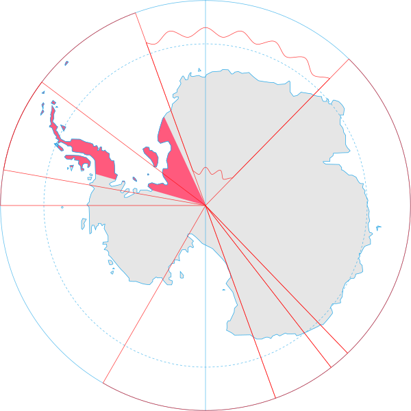
English: Map showing the territorial claim to Antarctica by the country in the filename. Also on the map are is the 60° S Parallel, Antarctic Circle, 0/180 latitude line and (in red) the borders of the claims by other states. |
| ڕێکەوت | |
| سەرچاوە | Generated from Antarctica by Lokal_Profil. |
| بەرھەمھێنەر | Lokal_Profil |
| ڕێپێدان (بەکارھێنانەوەی ئەم پەڕگەیە) |
This file is licensed under the Creative Commons Attribution-Share Alike 2.5 Generic license. دانەپاڵ: Lokal_Profil
|
مێژووی پەڕگە
کرتە بکە لەسەر یەکێک لە ڕێکەوت/کاتەکان بۆ بینینی پەڕگەکە بەو شێوەی لەو کاتەدا بووە.
| ڕێکەوت/کات | ھێما | ئەندازە | بەکارھێنەر | تێبینی | |
|---|---|---|---|---|---|
| هەنووکە | ٢٠:٥٥، ٣٠ی حوزەیرانی ٢٠٠٨ | | ٨٠٦ لە ٨٠٦ (٦٥ کیلۆبایت) | Lokal Profil | {{Information |Description={{en|Map showing the territorial claim to Antarctica by the country in the filename. Also on the map are is the 60° S Parallel, Antarctic Circle, 0/180 latitude line and (in red) the borders of the claims by other states.}} |So |
بەکارھێنانی پەڕگە
ئەم پەڕەی 2ە ئەم پەڕگەیە بەکار دەھێنێت:
بەکارھێنانی سەرانسەریی پەڕگە
ئەم ویکیانەی دیکەی خوارەوەش ئەم پەڕگە بەکاردێنن:
- بەکارھێنان لە af.wikipedia.org
- بەکارھێنان لە ar.wikipedia.org
- بەکارھێنان لە ast.wikipedia.org
- بەکارھێنان لە az.wikipedia.org
- بەکارھێنان لە ca.wikipedia.org
- بەکارھێنان لە chr.wikipedia.org
- بەکارھێنان لە cs.wikipedia.org
- بەکارھێنان لە da.wikipedia.org
- بەکارھێنان لە de.wikipedia.org
- بەکارھێنان لە diq.wikipedia.org
- بەکارھێنان لە el.wikipedia.org
- بەکارھێنان لە en.wikipedia.org
- بەکارھێنان لە eo.wikipedia.org
- بەکارھێنان لە et.wikipedia.org
- بەکارھێنان لە eu.wikipedia.org
- بەکارھێنان لە fa.wikipedia.org
- بەکارھێنان لە fi.wikipedia.org
- بەکارھێنان لە frr.wikipedia.org
- بەکارھێنان لە fr.wikipedia.org
- بەکارھێنان لە gl.wikipedia.org
- بەکارھێنان لە gv.wikipedia.org
- بەکارھێنان لە hu.wikipedia.org
- بەکارھێنان لە hy.wikipedia.org
- بەکارھێنان لە id.wikipedia.org
- بەکارھێنان لە ilo.wikipedia.org
- بەکارھێنان لە it.wikipedia.org
- بەکارھێنان لە ja.wikipedia.org
بینینی بەکارھێنانی گشتی زیاتری ئەم پەڕگەیە.