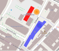
پەڕگە:2011 Oslo attacks map.svg

Size of this PNG preview of this SVG file: ٦٠٣ لە ٥٢٤ پیکسەڵ. ڕێزەلووشنەکانی تر: ٢٧٦ لە ٢٤٠ پیکسەڵ | ٥٥٢ لە ٤٨٠ پیکسەڵ | ٨٨٤ لە ٧٦٨ پیکسەڵ | ١٬١٧٨ لە ١٬٠٢٤ پیکسەڵ | ٢٬٣٥٧ لە ٢٬٠٤٨ پیکسەڵ.
پەڕگەی سەرەکی (پەڕگەی SVG، بە ناو ٦٠٣ × ٥٢٤ پیکسەڵ، قەبارەی پەڕگە: ٥١٦ کیلۆبایت)
مێژووی پەڕگە
کرتە بکە لەسەر یەکێک لە ڕێکەوت/کاتەکان بۆ بینینی پەڕگەکە بەو شێوەی لەو کاتەدا بووە.
| ڕێکەوت/کات | ھێما | ئەندازە | بەکارھێنەر | تێبینی | |
|---|---|---|---|---|---|
| هەنووکە | ١٠:٣٦، ٢٣ی تەممووزی ٢٠١١ |  | ٦٠٣ لە ٥٢٤ (٥١٦ کیلۆبایت) | Beao | Minor positioning. |
| ١٠:٣٤، ٢٣ی تەممووزی ٢٠١١ |  | ٦٠٣ لە ٥٢٤ (٥١٦ کیلۆبایت) | Beao | {{Information |Description={{en|1=Map over the ''2011 Oslo attacks''. <br>''Red building'': Government building.<br>''Orange area'': Position of the remains of the exploded car.<br>''Blue building'': Oil Ministry building.}} |Source=*[[:File:2011_Oslo_att |
بەکارھێنانی پەڕگە
ئەم پەڕەیە ئەم پەڕگەیە بەکار دەھێنێت:
بەکارھێنانی سەرانسەریی پەڕگە
ئەم ویکیانەی دیکەی خوارەوەش ئەم پەڕگە بەکاردێنن:
- بەکارھێنان لە be-tarask.wikipedia.org
- بەکارھێنان لە be.wikipedia.org
- بەکارھێنان لە bg.wikipedia.org
- بەکارھێنان لە bs.wikipedia.org
- بەکارھێنان لە cs.wikipedia.org
- بەکارھێنان لە da.wikipedia.org
- بەکارھێنان لە eo.wikipedia.org
- بەکارھێنان لە eu.wikipedia.org
- بەکارھێنان لە fa.wikipedia.org
- بەکارھێنان لە fi.wikipedia.org
- بەکارھێنان لە fr.wikipedia.org
- بەکارھێنان لە hr.wikipedia.org
- بەکارھێنان لە hy.wikipedia.org
- بەکارھێنان لە it.wikipedia.org
- بەکارھێنان لە ja.wikipedia.org
- بەکارھێنان لە ko.wikipedia.org
- بەکارھێنان لە la.wikipedia.org
- بەکارھێنان لە mzn.wikipedia.org
- بەکارھێنان لە pl.wikipedia.org
- بەکارھێنان لە pt.wikipedia.org
- بەکارھێنان لە ru.wikipedia.org
- بەکارھێنان لە ru.wikinews.org
- بەکارھێنان لە simple.wikipedia.org
- بەکارھێنان لە sr.wikipedia.org
- بەکارھێنان لە th.wikipedia.org
- بەکارھێنان لە uk.wikipedia.org
- بەکارھێنان لە www.wikidata.org
- بەکارھێنان لە zh.wikipedia.org