پەڕگە:Umayyad750ADloc-ar.png

قەبارەی ئەم پێشبینینە: ٨٠٠ لە ٤٨٧ پیکسەڵ. ڕێزەلووشنەکانی تر: ٣٢٠ لە ١٩٥ پیکسەڵ | ٦٤٠ لە ٣٩٠ پیکسەڵ | ١٬٠٢٤ لە ٦٢٤ پیکسەڵ | ١٬٤٨١ لە ٩٠٢ پیکسەڵ.
پەڕگەی سەرەکی (١٬٤٨١ × ٩٠٢ پیکسڵ، قەبارەی پەڕگە: ٤٦ کیلۆبایت، جۆری ئێم ئای ئێم ئی: image/png)
کورتە
| وەسف |
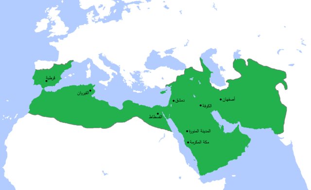
العربية: خارطة تُظهر المساحة التي امتدَّت عليها الدولة الأُمويَّة في أقصى اتساعها وذُروة قوَّتها، حوالي سنة 750م. (الرسم مبني بشكلٍ جُزئيّ على كتاب "أطلس تاريخ العالم" (2007) - العالم ما بين سنتيّ 500 و750م، الخارطة.) |
| ڕێکەوت | (UTC) |
| سەرچاوە |
This file was derived from: Umayyad750ADloc.png: |
| بەرھەمھێنەر |
|
| This is a retouched picture, which means that it has been digitally altered from its original version. Modifications: Translated to Arabic - عُرِّبت. The original can be viewed here: Umayyad750ADloc.png:
|
مۆڵەتنامە
من، ھەڵگری مافی لەبەرگرتنەوەی ئەم بەرھەمە، لەژێر ئەم مۆڵەتنامەیەدا بڵاوی دەکەمەوە:
This file is licensed under the Creative Commons Attribution 3.0 Unported license.
- تۆ ئازادی:
- بۆ بڵاکردنەوە – بۆ کۆپی کردن، دابەشکردن و دەستبەدەست ناردنی
- بۆ تێکەڵکردنەوە – بۆ سازاندنی کارەکە
- بەم مەرجانەی خوارەوە:
- دانەپاڵ – پێویستە باوەڕی گونجاو بدەیت، بەستەرێک بۆ مۆڵەتەکە دابین بکەیت و ئاماژە بەوە بکەیت کە ئایا گۆڕانکاری کراوە یان نا. دەتوانیت بە هەر شێوەیەکی گونجاو ئەوە بکەیت، بەڵام بە شێوەیەک نا کە وا دەربکەوێت کە مۆڵەتدەر پشتگیری تۆ یان بەکارهێنانەکەت بکات.
Original upload log
This image is a derivative work of the following images:
- File:Umayyad750ADloc.png licensed with Cc-by-3.0
- 2013-04-11T15:24:29Z HistoryofIran 1481x902 (30417 Bytes) {{subst:Upload marker added by en.wp UW}} {{Information |Description = {{en|Made the map more presice, the Umayyads never controlled Tabaristan because of the Dabuyid dynasty, but the Abbasids did that later.}} |Source = http
- 2013-04-10T15:55:41Z Khateeb88 1481x902 (38391 Bytes) Added the major cities of the Umayyad Caliphate: Damascus, Kufa, Isfahan, Mecca, Medina, Fustat, Kairouan, and Cordoba.
- 2013-04-10T15:54:28Z Khateeb88 1481x902 (38391 Bytes) Added the major cities of the Umayyad Caliphate: Damascus, Kufa, Isfahan, Mecca, Medina, Fustat, Kairouan, and Cordoba.
- 2009-04-22T16:17:51Z Gabagool 1481x902 (51495 Bytes) some corrections..
- 2009-04-20T16:10:54Z Gabagool 1481x902 (51573 Bytes) {{Information |Description={{en|1=Locator map for the Umayyad Caliphate at its greatest extent, c. AD 750. (Partially based on ''Atlas of World History'' (2007) - World 500-750, map.)}} |Source=Own work by uploader |Author=[
Uploaded with derivativeFX
مێژووی پەڕگە
کرتە بکە لەسەر یەکێک لە ڕێکەوت/کاتەکان بۆ بینینی پەڕگەکە بەو شێوەی لەو کاتەدا بووە.
| ڕێکەوت/کات | ھێما | ئەندازە | بەکارھێنەر | تێبینی | |
|---|---|---|---|---|---|
| هەنووکە | ١٣:٢٣، ١٦ی تشرینی دووەمی ٢٠١٣ | | ١٬٤٨١ لە ٩٠٢ (٤٦ کیلۆبایت) | باسم | {{Information |Description ={{en|1=map}} |Source =derevative |Author =me |Date =2013 |Permission = |other_versions = }} |
بەکارھێنانی پەڕگە
ئەم پەڕەیە ئەم پەڕگەیە بەکار دەھێنێت:
بەکارھێنانی سەرانسەریی پەڕگە
ئەم ویکیانەی دیکەی خوارەوەش ئەم پەڕگە بەکاردێنن:
- بەکارھێنان لە ar.wikipedia.org
- العراق
- الإسلام
- عمر بن عبد العزيز
- البصرة
- ولاية الجزائر
- القوقاز
- أبو العباس السفاح
- قائمة الخلفاء
- ويكيبيديا:في هذا اليوم/23 أبريل
- طريف بن مالك
- عمر بن هبيرة
- بوابة:الإمبراطورية الروسية
- بوابة:الإمبراطورية الروسية/بوابات شقيقة
- ويكيبيديا:مقالة الصفحة الرئيسية المختارة/197
- الممالك في إفريقيا قبل الاستعمار
- سعيد بن عمرو الحرشي
- بوابة:مكة/مقالة مختارة/أرشيف
- بوابة:مكة/مقالة مختارة/9
- بوابة:الأديان/تاريخ ديني/1
- بوابة:الأديان/تاريخ ديني
- قائمة السلالات الحاكمة الإسلامية
- بوابة:الإسلام/دولة مختارة
- بوابة:الإسلام/دولة مختارة/2
- بوابة:التاريخ/فقرات منوعة/أرشيف
- بوابة:التاريخ/فقرات منوعة/7
- بوابة:التاريخ الإسلامي/دولة مختارة/9
- بوابة:التاريخ الإسلامي/دولة مختارة/أرشيف
- بوابة:الإمبراطورية الألمانية
- بوابة:الإمبراطورية الألمانية/بوابات شقيقة
- بوابة:إمبراطورية اليابان
- بوابة:إمبراطورية اليابان/بوابات شقيقة
- بوابة:الخلافة الراشدة
- بوابة:الدولة الأموية
- بوابة:الدولة الأموية/واجهة
- مستخدم:عبد المؤمن/مصور/تاريخ إسلامي
- بوابة:الإمبراطورية الفرنسية الأولى/بوابات شقيقة
- بوابة:الإمبراطورية الفرنسية الأولى
- بوابة:الإمبراطورية النمساوية/بوابات شقيقة
- بوابة:الإمبراطورية النمساوية
- بوابة:العالم الإسلامي/مقالة مختارة/أرشيف
- بوابة:العالم الإسلامي/مقالة مختارة/1
- بوابة:العالم الإسلامي
- قالب:مواضيع متعلقة 3
- قالب:مواضيع متعلقة 3/شرح
- بوابة:العالم الإسلامي/تاريخ
- بوابة:العالم الإسلامي/مواضيع متعلقة
- بوابة:الإمبراطورية البريطانية
- بوابة:الإمبراطورية البريطانية/بوابات شقيقة
- بوابة:الإمبراطورية الفرنسية الثانية
- بوابة:الإمبراطورية الفرنسية الثانية/بوابات شقيقة
بینینی بەکارھێنانی گشتی زیاتری ئەم پەڕگەیە.