پەڕگە:UAEOMCmap.png
قەبارەی ئەم پێشبینینە: ٦٧١ لە ٥٩٩ پیکسەڵ. ڕێزەلووشنەکانی تر: ٢٦٩ لە ٢٤٠ پیکسەڵ | ٥٣٧ لە ٤٨٠ پیکسەڵ | ٩٢٨ لە ٨٢٩ پیکسەڵ.
پەڕگەی سەرەکی (٩٢٨ × ٨٢٩ پیکسڵ، قەبارەی پەڕگە: ٣٩ کیلۆبایت، جۆری ئێم ئای ئێم ئی: image/png)
کورتە
| وەسف |
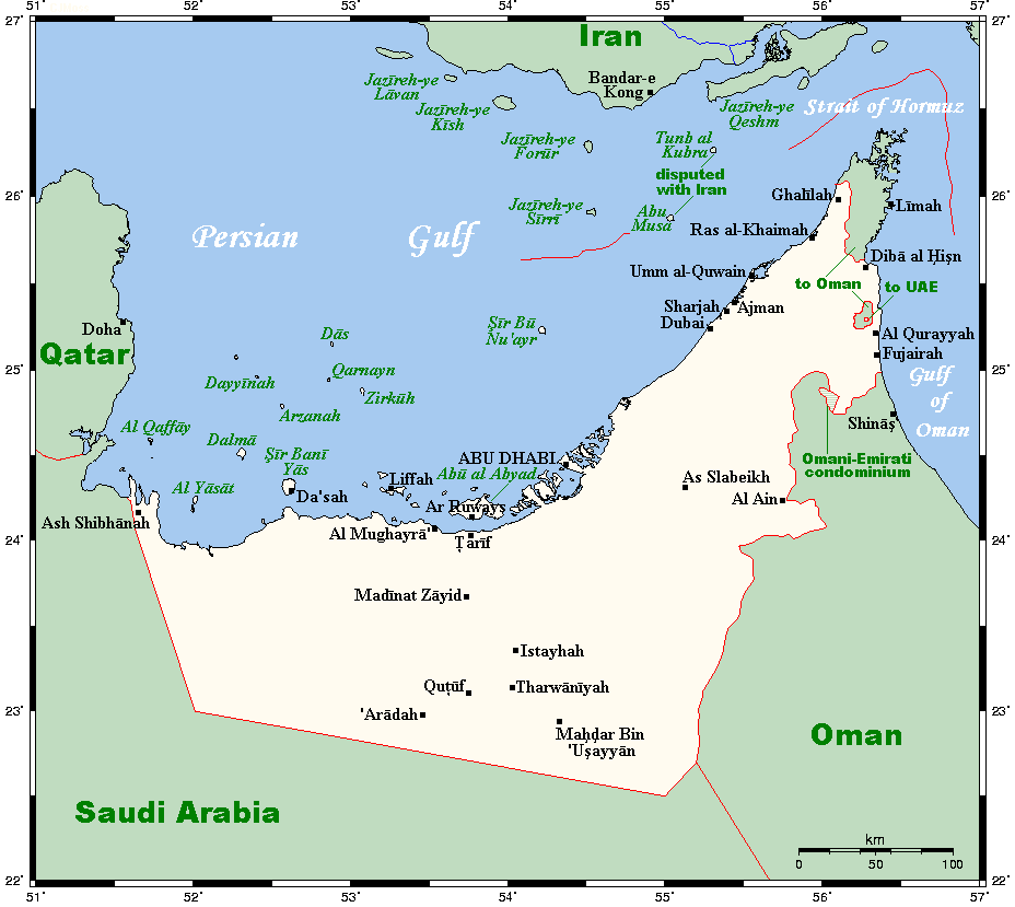
English: A map showing the UAE's cities and main towns, along with nearby areas. This map's source is here, with the uploader's modifications, and the GMT homepage says that the tools are released under the GNU General Public License. |
| ڕێکەوت | ٢٠ی تەممووزی ٢٠٠٧ (original upload date) |
| سەرچاوە | Transferred from en.wikipedia to Commons by Georgez. |
| بەرھەمھێنەر | Kelisi at ئینگلیزی ویکیپیدیا |
| وەشانەکانی تر | العربيَّة |
مۆڵەتنامە
Kelisi from en.wikipedia.org، ھەڵگری مافی لەبەرگرتنەوەی ئەم بەرھەمە، لەژێر ئەم مۆڵەتنامەیەدا بڵاوی دەکاتەوە:
| ئەم پەڕگەیە لە ژێر مۆڵەتنامەی
Creative Commons Attribution-Share Alike 3.0 Unported دایە. Subject to disclaimers. |
||
| دانەپاڵ: Kelisi from en.wikipedia.org | ||
| ||
| This licensing tag was added to this file as part of the GFDL licensing update. |

|
ڕێگەدراوە بە لەبەرگرتنەوە، دابەشکردن ھەروەھا/یان سازاندنی ئەم بەڵگەنامەیە لەژێر مەرجی مۆڵەتی GNU بۆ بەڵگەنامەی ئازاد، وەشانی ١.٢ یان ھەر وەشانێکی تری دواتر کە بڵاوکراوەتەوە لەلایەن دامەزراوەی بەرنامەی ئازاد، بەبێ ھیچ بەشێکی جیاواز، بەبێ نووسین لەسەر بەرگی پێشەوە و دواوەی. وێنەیەک لەمۆڵەتەکە لە بەشێکدا ھەیە کە ناوی مۆڵەتی GNU بۆ بەڵگەنامەی ئازادە. Subject to disclaimers. |
Original upload log
The original description page was here. All following user names refer to en.wikipedia.
- 2007-07-20 01:00 Kelisi 928×829× (31672 bytes) == Summary == A map showing the UAE's cities and main towns, along with nearby areas. This map's source is [http://www.aquarius.ifm-geomar.de/ here], with the uploader's modifications, and the [http://gmt.soest.hawaii.edu/ GMT homepage] says that the tool
مێژووی پەڕگە
کرتە بکە لەسەر یەکێک لە ڕێکەوت/کاتەکان بۆ بینینی پەڕگەکە بەو شێوەی لەو کاتەدا بووە.
| ڕێکەوت/کات | ھێما | ئەندازە | بەکارھێنەر | تێبینی | |
|---|---|---|---|---|---|
| هەنووکە | ١٧:٥٤، ٣٠ی کانوونی دووەمی ٢٠٢١ | | ٩٢٨ لە ٨٢٩ (٣٩ کیلۆبایت) | Kelisi | The Saudi-Qatari border has been adjusted to reflect what current maps generally show. Source was Open Street Map, which I always find to be the trustworthiest in such matters (and, of course, the freest as well; so there is no copyright to worry about). |
| ١٥:٥٥، ٢٥ی ئازاری ٢٠٠٩ |  | ٩٢٨ لە ٨٢٩ (٣١ کیلۆبایت) | Georgez | {{Information |Description={{en|A map showing the UAE's cities and main towns, along with nearby areas. This map's source is [http://www.aquarius.ifm-geomar.de/ here], with the uploader's modifications, and the [http://gmt.soest.hawaii.edu/ GMT homepage] |
بەکارھێنانی پەڕگە
ئەم پەڕەیە ئەم پەڕگەیە بەکار دەھێنێت:
بەکارھێنانی سەرانسەریی پەڕگە
ئەم ویکیانەی دیکەی خوارەوەش ئەم پەڕگە بەکاردێنن:
- بەکارھێنان لە ar.wikipedia.org
- بەکارھێنان لە ca.wikipedia.org
- بەکارھێنان لە en.wikipedia.org
- بەکارھێنان لە eo.wikipedia.org
- بەکارھێنان لە es.wikipedia.org
- بەکارھێنان لە fa.wikipedia.org
- بەکارھێنان لە fr.wikipedia.org
- بەکارھێنان لە hr.wikipedia.org
- بەکارھێنان لە id.wikipedia.org
- بەکارھێنان لە it.wikipedia.org
- بەکارھێنان لە ja.wikipedia.org
- بەکارھێنان لە nl.wikipedia.org
- بەکارھێنان لە nn.wikipedia.org