پەڕگە:Map-Germany-1945.svg
پەڕگەی سەرەکی(پەڕگەی SVG، بە ناو ٣٬٤٩٢ × ٢٬٩٦٦ پیکسەڵ، قەبارەی پەڕگە: ٧٢٦ کیلۆبایت)

ئەم پەڕگە لە Wikimedia Commonsەوەیە و لەوانەیە لە پڕۆژەکانی دیکەش بەکار ھاتبێت. پێناسەکەی لەسەر پەڕەی وەسفی پەڕگەکە لە خوارەوە نیشان دراوە.

کورتە

وەسف
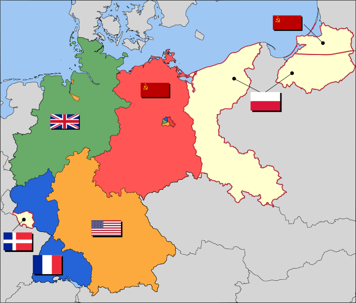
العربية: حدود المناطق المحتلة في ألمانيا عام 1957. الاراضي شرق خط نيس تحت السيطرة البولندية والسوفييتية، تظهر بلون ابيض. برلين منطقة مسيطر عليها من عدة بلدان داخل المنطقة السوفييتة.
English: Occupation zone borders in Germany, 1947. The territories east of the Oder-Neisse line, under Polish and Soviet administration/annexation, are shown as cream as is the likewise detached Saar protectorate. Berlin is the multinational area within the Soviet zone.
Français : Carte des zones d'occupation de l'Allemagne : le protectorat français de la Sarre apparait en blanc-crème, comme la Silésie, la Poméranie et les autres régions allemandes orientales annexées par la Pologne et l'Union Soviétique.
Deutsch: Grenzen der Besatzungszonen in Deutschland, 1947. Die Gebiete östlich der Oder-Neiße-Grenze, unter polnischer und sowjetischer Verwaltung/Annexion, sowie das Saar-Protektorat sind cremefarben dargestellt. Berlin ist ein multinationales Gebiet inmitten der sowjetischen Besatzungszone.
ڕێکەوت ١٧ی ئازاری ٢٠٠٨ (original upload date)
سەرچاوە Based on map data of the IEG-Maps project (Andreas Kunz, B. Johnen and Joachim Robert Moeschl: University of Mainz) - www.ieg-maps.uni-mainz.de.
بەرھەمھێنەر User:52 Pickup
SVG genesis
InfoField
 
The source code of this SVG is invalid due to 11 errors.
 
This W3C-invalid map was created with Inkscape…important.

مۆڵەتنامە

w:en:Creative Commons
دانەپاڵ بڵاوکردنەوەی گونجاو
This file is licensed under the Creative Commons Attribution-Share Alike 2.5 Generic license.
تۆ ئازادی:
  • بۆ بڵاکردنەوە – بۆ کۆپی کردن، دابەشکردن و دەستبەدەست ناردنی
  • بۆ تێکەڵکردنەوە – بۆ سازاندنی کارەکە
بەم مەرجانەی خوارەوە:
  • دانەپاڵ – پێویستە باوەڕی گونجاو بدەیت، بەستەرێک بۆ مۆڵەتەکە دابین بکەیت و ئاماژە بەوە بکەیت کە ئایا گۆڕانکاری کراوە یان نا. دەتوانیت بە هەر شێوەیەکی گونجاو ئەوە بکەیت، بەڵام بە شێوەیەک نا کە وا دەربکەوێت کە مۆڵەتدەر پشتگیری تۆ یان بەکارهێنانەکەت بکات.
  • بڵاوکردنەوەی گونجاو – ئەگەر لەسەر بنەمای ئەم کارە تێکەڵ، گۆڕان، یان ساز بکەی، پێویستە بەشدارییەکانت بە هەمان مۆڵەت یان هاوشێوەی مۆڵەتی ئەسڵی دابەش بکەی.

Original upload log

Transferred from en.wikipedia to Commons by Broadbeer using CommonsHelper.

The original description page was here. All following user names refer to en.wikipedia.
  • 2008-03-17 19:50 52 Pickup 3492×2966× (760290 bytes) Changes to fill and border colours. Made differences clearer between occupation zones and eventual territorial losses.
  • 2007-08-31 14:57 52 Pickup 3492×2966× (755561 bytes) New version: regions placed under Polish and Soviet administration now presented slightly differently (borders instead of colour fill), Saar colour now only slightly different to French zone (still needs some work)
  • 2007-08-10 09:50 52 Pickup 3492×2966× (751829 bytes) oops, now with fixed image size
  • 2007-08-10 09:47 52 Pickup 744×1052× (751774 bytes) {{Information| |Description= Germany in the aftermath of World War II: 1 September 1945 |Source= Based on map data of the IEG-Maps project (Andreas Kunz, B. Johnen and Joachim Robert Moeschl: University of Mainz) - [http://www.ieg-maps.uni-mainz.de www.ie
Annotations
InfoField
This image is annotated: View the annotations at Commons

لێدوانەکان

Add a one-line explanation of what this file represents
Occupation map of Germany after WW2

بەندەکانی لەم پەڕگەیەدا دەردەکەون

depicts ئینگلیزی

١٧ ئازاری 2008

У ئینگلیزی

1+2=Paradise ئینگلیزی

Tyler, the Creator ئینگلیزی

Torslanda Airport ئینگلیزی

مێژووی پەڕگە

کرتە بکە لەسەر یەکێک لە ڕێکەوت/کاتەکان بۆ بینینی پەڕگەکە بەو شێوەی لەو کاتەدا بووە.

ڕێکەوت/کاتھێمائەندازەبەکارھێنەرتێبینی
هەنووکە‏٠٤:٣٧، ١ی کانوونی یەکەمی ٢٠١٧ھێما بۆ وەشانی  ‏٠٤:٣٧، ١ی کانوونی یەکەمی ٢٠١٧٣٬٤٩٢ لە ٢٬٩٦٦ (٧٢٦ کیلۆبایت)SammimackUpdated flags and colours
‏١٤:١٣، ٣ی تەممووزی ٢٠١٥ھێما بۆ وەشانی  ‏١٤:١٣، ٣ی تەممووزی ٢٠١٥٣٬٤٩٢ لە ٢٬٩٦٦ (٧٢٨ کیلۆبایت)LichaoshengNew 48-Star US Flag from File:US flag 48 stars.svg
‏١٤:٠٠، ٣ی تەممووزی ٢٠١٥ھێما بۆ وەشانی  ‏١٤:٠٠، ٣ی تەممووزی ٢٠١٥٣٬٤٩٢ لە ٢٬٩٦٦ (٧٤٢ کیلۆبایت)LichaoshengReverted to version as of 18:46, 8 October 2008
‏١٥:١٩، ٤ی شوباتی ٢٠١٢ھێما بۆ وەشانی  ‏١٥:١٩، ٤ی شوباتی ٢٠١٢٣٬٤٩٢ لە ٢٬٩٦٦ (٧٤٢ کیلۆبایت)AnonMoosReverted to version as of 18:46, 8 October 2008 -- Kaliningrad had quite different status and fate from that of East Germany proper...
‏١٩:٤٤، ٢٠ی کانوونی دووەمی ٢٠١٢ھێما بۆ وەشانی  ‏١٩:٤٤، ٢٠ی کانوونی دووەمی ٢٠١٢٣٬٤٩٢ لە ٢٬٩٦٦ (٧٤٢ کیلۆبایت)Sammy pomponKaliningrado is occuped by USSR.
‏١٨:٤٦، ٨ی تشرینی یەکەمی ٢٠٠٨ھێما بۆ وەشانی  ‏١٨:٤٦، ٨ی تشرینی یەکەمی ٢٠٠٨٣٬٤٩٢ لە ٢٬٩٦٦ (٧٤٢ کیلۆبایت)File Upload Bot (Magnus Manske) {{BotMoveToCommons|en.wikipedia}} {{Information |Description={{en|Occupation zone borders in Germany, 1947. The territories east of the en:Oder-Neisse line, under Polish and Soviet administration/annexation, are shown as white as is the likewise det

ئەم پەڕەی 3ە ئەم پەڕگەیە بەکار دەھێنێت:

بەکارھێنانی سەرانسەریی پەڕگە

ئەم ویکیانەی دیکەی خوارەوەش ئەم پەڕگە بەکاردێنن:

بینینی بەکارھێنانی گشتی زیاتری ئەم پەڕگەیە.

دراوی مێتا