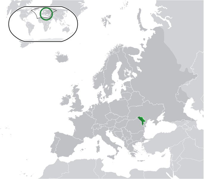
پەڕگە:Location Moldova Europe.png

قەبارەی ئەم پێشبینینە: ٦٨٥ لە ٦٠٠ پیکسەڵ. ڕێزەلووشنەکانی تر: ٢٧٤ لە ٢٤٠ پیکسەڵ | ٥٤٨ لە ٤٨٠ پیکسەڵ | ٨٧٧ لە ٧٦٨ پیکسەڵ | ١٬١٧٠ لە ١٬٠٢٤ پیکسەڵ | ٢٬٠٥٦ لە ١٬٨٠٠ پیکسەڵ.
پەڕگەی سەرەکی (٢٬٠٥٦ × ١٬٨٠٠ پیکسڵ، قەبارەی پەڕگە: ٤٢٢ کیلۆبایت، جۆری ئێم ئای ئێم ئی: image/png)
مێژووی پەڕگە
کرتە بکە لەسەر یەکێک لە ڕێکەوت/کاتەکان بۆ بینینی پەڕگەکە بەو شێوەی لەو کاتەدا بووە.
| ڕێکەوت/کات | ھێما | ئەندازە | بەکارھێنەر | تێبینی | |
|---|---|---|---|---|---|
| هەنووکە | ٠٩:٥٨، ٢٢ی ئایاری ٢٠٢١ |  | ٢٬٠٥٦ لە ١٬٨٠٠ (٤٢٢ کیلۆبایت) | Lupishor | Reverted to version as of 23:13, 11 July 2020 (UTC) Map is wrong, showing a part of Ukraine as part of Moldova |
| ١٨:١٠، ١٩ی ئایاری ٢٠٢١ |  | ٢٬٠٥٦ لە ١٬٨٠٠ (٣٢٧ کیلۆبایت) | Yesua Rafael Jara Alcivar | Reverted to version as of 01:27, 19 May 2021 (UTC) | |
| ٠١:٢٧، ١٩ی ئایاری ٢٠٢١ |  | ٢٬٠٥٦ لە ١٬٨٠٠ (٤٢٦ کیلۆبایت) | Yesua Rafael Jara Alcivar | Reverted to version as of 01:20, 19 May 2021 (UTC) | |
| ٠١:٢٧، ١٩ی ئایاری ٢٠٢١ |  | ٢٬٠٥٦ لە ١٬٨٠٠ (٣٢٧ کیلۆبایت) | Yesua Rafael Jara Alcivar | Agregando sus verdaderos territorios | |
| ٠١:٢٠، ١٩ی ئایاری ٢٠٢١ |  | ٢٬٠٥٦ لە ١٬٨٠٠ (٤٢٦ کیلۆبایت) | Yesua Rafael Jara Alcivar | Añadiendo territorios que le pertenecen | |
| ٢٣:١٣، ١١ی تەممووزی ٢٠٢٠ |  | ٢٬٠٥٦ لە ١٬٨٠٠ (٤٢٢ کیلۆبایت) | De728631 | added South Sudan to World map | |
| ١٥:٥٧، ٢٢ی شوباتی ٢٠١٠ |  | ٢٬٠٥٦ لە ١٬٨٠٠ (٣٥٥ کیلۆبایت) | Dinamik | colors | |
| ٢٣:٣٤، ١٧ی حوزەیرانی ٢٠٠٩ |  | ٢٬٠٥٦ لە ١٬٨٠٠ (٣٦٥ کیلۆبایت) | Bosonic dressing | {{Information |Description={{en|1=Moldova (green) / Transnistria (light green) / Europe (all green & dark grey); inspired by and consistent with general country locator maps by User:Vardion, et al}} |Source=Own work by uploader |Author=[[User:Bosonic dres |
بەکارھێنانی پەڕگە
ئەم پەڕەیە ئەم پەڕگەیە بەکار دەھێنێت:
بەکارھێنانی سەرانسەریی پەڕگە
ئەم ویکیانەی دیکەی خوارەوەش ئەم پەڕگە بەکاردێنن:
- بەکارھێنان لە af.wikipedia.org
- بەکارھێنان لە af.wiktionary.org
- بەکارھێنان لە ami.wikipedia.org
- بەکارھێنان لە an.wikipedia.org
- بەکارھێنان لە ar.wikipedia.org
- بەکارھێنان لە ary.wikipedia.org
- بەکارھێنان لە arz.wikipedia.org
- بەکارھێنان لە ast.wikipedia.org
- بەکارھێنان لە avk.wikipedia.org
- بەکارھێنان لە awa.wikipedia.org
- بەکارھێنان لە azb.wikipedia.org
- بەکارھێنان لە az.wikipedia.org
- بەکارھێنان لە az.wiktionary.org
- بەکارھێنان لە ban.wikipedia.org
- بەکارھێنان لە ba.wikipedia.org
- بەکارھێنان لە be-tarask.wikipedia.org
- بەکارھێنان لە be.wikipedia.org
- بەکارھێنان لە bh.wikipedia.org
- بەکارھێنان لە bi.wikipedia.org
- بەکارھێنان لە bn.wikipedia.org
- بەکارھێنان لە bo.wikipedia.org
- بەکارھێنان لە bs.wikipedia.org
- بەکارھێنان لە bxr.wikipedia.org
- بەکارھێنان لە ca.wikipedia.org
- بەکارھێنان لە cbk-zam.wikipedia.org
- بەکارھێنان لە ce.wikipedia.org
- بەکارھێنان لە chr.wikipedia.org
- بەکارھێنان لە csb.wikipedia.org
- بەکارھێنان لە cs.wikipedia.org
- بەکارھێنان لە cv.wikipedia.org
- بەکارھێنان لە cy.wikipedia.org
- بەکارھێنان لە de.wikipedia.org
- بەکارھێنان لە diq.wikipedia.org
- بەکارھێنان لە dty.wikipedia.org
- بەکارھێنان لە dv.wikipedia.org
- بەکارھێنان لە el.wikipedia.org
- بەکارھێنان لە el.wikivoyage.org
- بەکارھێنان لە en.wikipedia.org
بینینی بەکارھێنانی گشتی زیاتری ئەم پەڕگەیە.
