پەڕگە:Eritrea and Northern Ethiopia shaded relief map 1999, CIA.jpg

قەبارەی ئەم پێشبینینە: ٥٠٦ لە ٦٠٠ پیکسەڵ. ڕێزەلووشنەکانی تر: ٢٠٢ لە ٢٤٠ پیکسەڵ | ٤٠٥ لە ٤٨٠ پیکسەڵ | ٦٤٨ لە ٧٦٨ پیکسەڵ | ١٬٠٧٠ لە ١٬٢٦٨ پیکسەڵ.
پەڕگەی سەرەکی (١٬٠٧٠ × ١٬٢٦٨ پیکسڵ، قەبارەی پەڕگە: ٣٢٢ کیلۆبایت، جۆری ئێم ئای ئێم ئی: image/jpeg)
کورتە
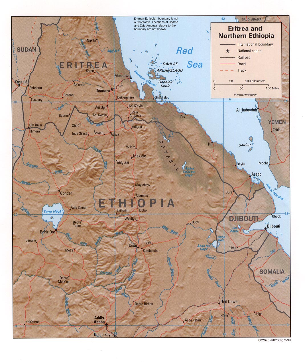
| وەسف | Eritrea and Northern Ethiopia (Shaded Relief), 1999 |
| ڕێکەوت | |
| سەرچاوە |
University of Texas Libraries, Perry-Castañeda Library Map Collection: Ethiopia Maps |
| بەرھەمھێنەر | CIA |
مۆڵەتنامە
| This image is a work of a Central Intelligence Agency employee, taken or made as part of that person's official duties. As a Work of the United States Government, this image or media is in the public domain in the United States.
|

|
مێژووی پەڕگە
کرتە بکە لەسەر یەکێک لە ڕێکەوت/کاتەکان بۆ بینینی پەڕگەکە بەو شێوەی لەو کاتەدا بووە.
| ڕێکەوت/کات | ھێما | ئەندازە | بەکارھێنەر | تێبینی | |
|---|---|---|---|---|---|
| هەنووکە | ١٧:٣٥، ٢٧ی ئەیلوولی ٢٠٠٥ | | ١٬٠٧٠ لە ١٬٢٦٨ (٣٢٢ کیلۆبایت) | Andro96~commonswiki | Eritrea and Northern Ethiopia (Shaded Relief) 1999 map was produced by the U.S. Central Intelligence Agency http://www.lib.utexas.edu/maps/ethiopia.html |
بەکارھێنانی پەڕگە
ئەم پەڕەیە ئەم پەڕگەیە بەکار دەھێنێت:
بەکارھێنانی سەرانسەریی پەڕگە
ئەم ویکیانەی دیکەی خوارەوەش ئەم پەڕگە بەکاردێنن:
- بەکارھێنان لە ca.wikipedia.org
- بەکارھێنان لە de.wikipedia.org
- بەکارھێنان لە de.wikibooks.org
- بەکارھێنان لە en.wikipedia.org
- بەکارھێنان لە fa.wikipedia.org
- بەکارھێنان لە id.wikipedia.org
- بەکارھێنان لە mzn.wikipedia.org
- بەکارھێنان لە nl.wikipedia.org
- بەکارھێنان لە www.wikidata.org
- بەکارھێنان لە zh.wikipedia.org